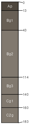
Tipp silty clay loam, 0 to 3 percent slopes, frequently flooded
Tipp
(80%)
Western Lowlands - Loamy Bottomland Riparian Forest
Cumulic Hapludolls
Well drained
Hydric: Yes
PAWS: 33 cm
flood plains
Aquents
(10%)
Hydric: Yes
PAWS: NA
depressions
Kobel
(10%)
Western Lowlands - Frequently Flooded and Ponded Oxbow and Swale Forest
Hydric: Yes
PAWS: NA
backswamps
SSA
Scale
Published
Export
ar147
1:24,000
1995
2025-09-10