| Aquents, 0 to 1 percent slopes, rarely flooded | AtA | 252 | 579212 | mfq8 | ar139 | 1992 | 1:24000 |
Aquents and Ustifluvents soils and water, 0 to 5 percent slopes | 6 | 2061 | 610871 | nhnj | az675 | 2009 | 1:24000 |
Aquents, flooded | 103 | 501 | 455879 | h9cs | ca087 | 1976 | 1:24000 |
Aquents-Aquolls-Riverwash complex, 0 to 5 percent slopes, flooded | 220 | 3410 | 467334 | hp99 | ca668 | 2007 | 1:24000 |
Aquents, fill areas | AC | 1161 | 457548 | hc3m | ca673 | 1974 | 1:24000 |
Aquic Torriorthents-Aquents complex, 0 to 2 percent slopes | 111bo | 245 | 2229102 | 2dtkj | ca732 | 1998 | 1:24000 |
Conway-Aquents-Watterson complex, 0 to 2 percent slopes | 169bo | 20 | 2229137 | 2dtln | ca732 | 1998 | 1:24000 |
Aquents-Aquolls-Riverwash complex, 0 to 5 percent slopes, flooded | 220ne | 64 | 2371012 | 2kl78 | ca760 | 1981 | 1:24000 |
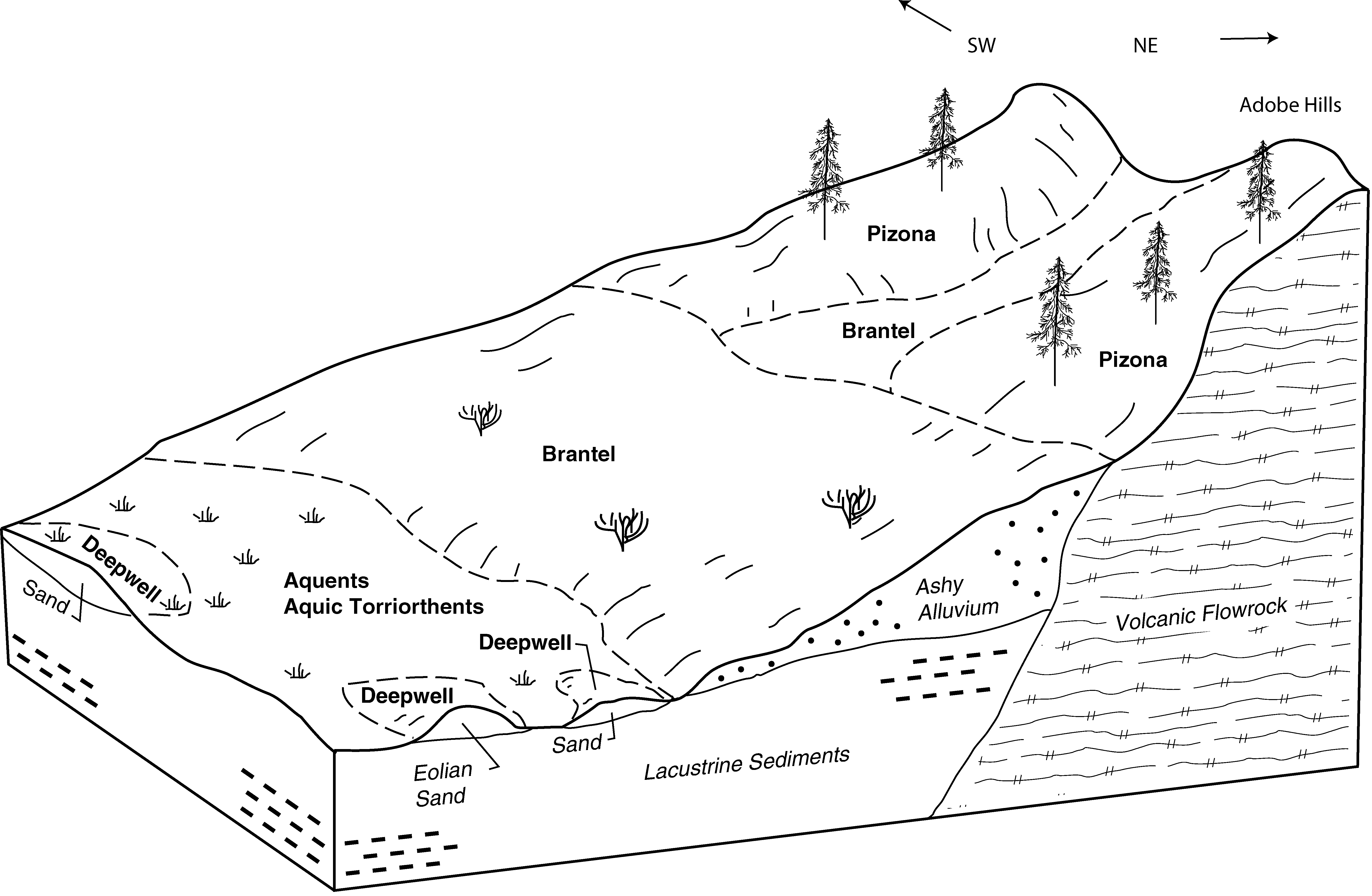
Aquic Torriorthents-Aquents-Deepwell complex, 0 to 15 percent slopes | 113bo | 133 | 2384087 | 2l0v1 | ca763 | 1984 | 1:24000 |
Aquic Torriorthents-Aquents complex, 0 to 2 percent slopes | 111bo | 21 | 2384086 | 2l0v0 | ca763 | 1984 | 1:24000 |
Aquents-Grunney complex, 0 to 4 percent slopes | 132 | 1424 | 2230131 | 2dvmq | ca777 | 1981 | 1:24000 |
Aquents-Riverwash complex, 0 to 4 percent slopes | 413 | 165 | 2230166 | 2dvnv | ca777 | 1981 | 1:24000 |
Aquic Torriorthents-Aquents complex, 0 to 2 percent slopes | 111 | 8048 | 488004 | jct2 | ca802 | 1996 | 1:24000 |
Aquic Torriorthents-Aquents-Deepwell complex, 0 to 15 percent slopes | 113 | 5215 | 488006 | jct4 | ca802 | 1996 | 1:24000 |
Conway-Aquents-Watterson complex, 0 to 2 percent slopes | 169 | 2729 | 488062 | jcvy | ca802 | 1996 | 1:24000 |
Aquents-Aquic torripsamments association, 0 to 2 percent slopes | 110 | 2027 | 488003 | jct1 | ca802 | 1996 | 1:24000 |
Aquic Torriorthents-Aquents-Cashbaugh association, 0 to 15 percent slopes | 112 | 964 | 488005 | jct3 | ca802 | 1996 | 1:24000 |
Aquolls and Aquents, gravelly substratum | 3 | 32744 | 95208 | 3627 | co618 | 1976 | 1:24000 |
Aquolls and Aquents, frequently flooded | 4 | 1200 | 498609 | jqv5 | co630 | 1975 | 1:24000 |
Pits | 30 | 950 | 1529434 | 1nbhl | fl035 | 1991 | 1:15840 |
Aquents, nearly level | 5 | 650 | 1477103 | 1ll1h | fl037 | 1990 | 1:20000 |
Aquents, gently undulating | 4 | 1622 | 1472725 | 1lfh8 | fl045 | 1997 | 1:24000 |
Aquents, organic substratum | 49 | 400 | 1151438 | 17n55 | fl051 | 1986 | 1:24000 |
Aquents, frequently flooded | 86 | 227 | 1416089 | 1jjk9 | fl121 | 2003 | 1:24000 |
Aquents, ponded, 0 to 1 percent slopes | AqA | 95 | 2686797 | 2rz9l | ga611 | 2012 | 1:24000 |
Aquents, ponded, 0 to 1 percent slopes | AqA | 960 | 3192363 | 2yync | ga613 | 1969 | 1:20000 |
Aquents loamy, reclaimed, 0 to 2 percent slopes | 5043 | 390 | 406489 | fmzk | ia079 | 1984 | 1:15840 |
Aquents, loamy, rarely flooded | 5045 | 334 | 447431 | h0l8 | ia133 | 1994 | 1:12000 |
Aquents, ponded, occasionally flooded | 5047 | 264 | 447433 | h0lb | ia133 | 1994 | 1:12000 |
Aquents, ponded, rarely flooded | 5046 | 187 | 447432 | h0l9 | ia133 | 1994 | 1:12000 |
Aquents-orthents complex | 5090 | 175 | 447435 | h0ld | ia133 | 1994 | 1:12000 |
Aquents, ponded, occasionally flooded | 5047 | 272 | 412953 | fvq2 | ia153 | 1993 | 1:12000 |
Aquents, ponded, occasionally flooded | 5047 | 11 | 413108 | fvw2 | ia177 | 1994 | 1:12000 |
Aquents, loamy, reclaimed, 0 to 2 percent slopes | 5043 | 47 | 412690 | fvfl | ia197 | 1988 | 1:15840 |
Riverwash-Aquents complex, nearly level | 110 | 977 | 79575 | 2nsy | id611 | 1994 | 1:24000 |
Aquents-Riverwash complex, nearly level | 2 | 2482 | 83089 | 2sg9 | id752 | 1999 | 1:24000 |
Aquents, clayey, undrained, nearly level | 1409A | 420 | 2518154 | 2qhrd | il031 | 2008 | 1:12000 |
Aquents, loamy, nearly level | 408 | 196 | 174838 | 5vxy | il035 | 1992 | 1:15840 |
Aquents loamy, level, frequently flooded | 3408A | 31 | 1612281 | 1r3q2 | il107 | 2006 | 1:12000 |
Darwin-Aquents-Urban land complex, 0 to 2 percent slopes, occasionally flooded, long duration | 2071L | 814 | 200826 | 6qz8 | il119 | 2001 | 1:12000 |
Darwin-Aquents-Urban land complex, 0 to 2 percent slopes, occasionally flooded, long duration | 2071L | 2317 | 182901 | 6qz8 | il163 | 1997 | 1:12000 |
Aquents-Urban land complex, 0 to 2 percent slopes | 2408A | 180 | 793109 | vm95 | il195 | 2003 | 1:12000 |
Urban land-Aquents, clayey substratum, complex, lake plain, 0 to 3 percent slopes | UedA | 3644 | 210847 | 72dj | in019 | 2001 | 1:12000 |
Urban land-Aquents, clayey substratum, complex, lake plain, 0 to 3 percent slopes | UedA | 1264 | 185201 | 66q7 | in043 | 2000 | 1:12000 |
Aquents, frequently flooded | Ao | 303 | 160101 | 5clk | in051 | 1986 | 1:15840 |
Orthents and aquents, loamy | Ot | 657 | 165284 | 5jzr | in065 | 1984 | 1:15840 |
Udorthents-Aquents complex | UcvA | 1334 | 1907659 | 2212d | in071 | 1985 | 1:15840 |
Aquents-Urban land complex, rarely flooded | Ao | 1953 | 160847 | 5dcm | in085 | 1985 | 1:20000 |
Aquents, frequently flooded | 9968 | 984 | 1453690 | 1ksp7 | ks073 | 1981 | 1:24000 |
Aquents, frequently ponded | 9969 | 91 | 1443869 | 1kggf | ks155 | 1999 | 1:24000 |
Aquents, frequently flooded | 9968 | 158 | 1427212 | 1jx43 | ks207 | 1973 | 1:20000 |
Aquents dredged, 0 to 3 percent slopes, frequently flooded | ATB | 51 | 376925 | dn6w | la001 | 2000 | 1:24000 |
Levees-Borrow pits complex, 0 to 25 percent slopes | Lp | 866 | 2539639 | 2qr6g | la005 | 1972 | 1:24000 |
Aquents, dredged | At | 308 | 1014646 | 131tj | la005 | 1972 | 1:24000 |
Aquents, frequently flooded | AN | 2303 | 1413668 | 1jg16 | la019 | 1983 | 1:24000 |
Aquents, frequently flooded | AN | 8022 | 1723511 | 1vvg4 | la023 | 1986 | 1:24000 |
Aquents, frequently flooded | AT | 582 | 913476 | znjz | la033 | 2007 | 1:24000 |
Aquents, dredged, 1 to 5 percent slopes, occasionally flooded | Az | 586 | 824204 | wnn7 | la045 | 1973 | 1:24000 |
Levees-Borrow pits complex, 0 to 25 percent slopes | LE | 2030 | 1451376 | 1kq8l | la047 | 1975 | 1:24000 |
Levees-Borrow pits complex, 0 to 25 percent slopes | LV | 587 | 1413446 | 1jft1 | la051 | 1981 | 1:24000 |
Aquents | AQ | 280 | 1413449 | 1jft4 | la051 | 1981 | 1:24000 |
Aquents, dredged, 1 to 5 percent slopes, occasionally flooded | ATB | 14 | 808510 | w49z | la057 | 1981 | 1:24000 |
Aquents, dredged | At | 2204 | 569731 | m3vf | la063 | 1987 | 1:24000 |
Aquents, dredged, frequently flooded | AT | 8397 | 569879 | m406 | la071 | 1987 | 1:24000 |
Aquents, dredged | An | 6873 | 569881 | m408 | la071 | 1987 | 1:24000 |
Levees-Borrow pits complex, 0 to 25 percent slopes | LV | 677 | 1413363 | 1jfqc | la071 | 1987 | 1:24000 |
Levees-Borrow pits complex, 0 to 25 percent slopes | LV | 852 | 1725321 | 1vxbj | la073 | 1969 | 1:24000 |
Aquents, dredged, frequently flooded | AT | 24380 | 1598649 | 1qnjb | la075 | 1988 | 1:24000 |
Aquents, dredged | AN | 404 | 1598648 | 1qnj9 | la075 | 1988 | 1:24000 |
Aquents, dredged, frequently flooded | AD | 17630 | 375347 | dlkz | la087 | 1984 | 1:24000 |
Levees-Borrow pits complex, 0 to 25 percent slopes | LV | 65 | 1407363 | 1j7gt | la087 | 1984 | 1:24000 |
Levees-Borrow pits complex, 0 to 25 percent slopes | LV | 722 | 1413362 | 1jfqb | la089 | 1984 | 1:24000 |
Aquents | AQ | 78 | 1413361 | 1jfq9 | la089 | 1984 | 1:24000 |
Levees-Borrow pits complex, 0 to 25 percent slopes | Lp | 1113 | 1415797 | 1jj7w | la093 | 2007 | 1:24000 |
Levees-Borrow pits complex, 0 to 25 percent slopes | LP | 618 | 576692 | mc2z | la095 | 2004 | 1:24000 |
Aquents, dredged, 1 to 5 percent slopes, occasionally flooded | ATB | 446 | 824162 | wnlw | la099 | 1974 | 1:24000 |
Aquents, dredged, 1 to 5 percent slopes, occasionally flooded | ATB | 19687 | 378478 | dptz | la101 | 1999 | 1:24000 |
Aquents, dredged | ATA | 1831 | 378479 | dpv0 | la101 | 1999 | 1:24000 |
Aquents, dredged | Ag | 3844 | 326994 | bz86 | la103 | 1985 | 1:24000 |
Aquents, dredged, 1 to 5 percent slopes, occasionally flooded | ATB | 21218 | 393663 | f6mt | la109 | 2001 | 1:24000 |
Aquents, dredged | ATA | 1699 | 393662 | f6ms | la109 | 2001 | 1:24000 |
Aquents, frequently flooded | AN | 1752 | 1539683 | 1np56 | la113 | 1988 | 1:24000 |
Histosols and Aquents, ponded | 86 | 3414 | 190377 | 6d36 | mi001 | 1993 | 1:20000 |
Aquents and Histosols, ponded | 280 | 446 | 190305 | 6d0w | mi001 | 1993 | 1:20000 |
Histosols and Aquents, ponded | 60 | 4902 | 1455284 | 1kvbn | mi003 | 2007 | 1:24000 |
Aquents and Histosols, ponded | 50 | 6767 | 212473 | 742z | mi005 | 1984 | 1:15840 |
Aquents, sandy and loamy | 34 | 1101 | 212458 | 742h | mi005 | 1984 | 1:15840 |
Histosols and Aquents, ponded | 86 | 3298 | 191309 | 6f28 | mi007 | 1998 | 1:12000 |
Histosols and Aquents, ponded | HsfaaA | 88 | 3155916 | 2ycxj | mi009 | 1976 | 1:15840 |
Aquents, sandy and loamy | Aq | 25 | 2507821 | 683g | mi011 | 1964 | 1:20000 |
Histosols and Aquents, 0 to 1 percent slopes, ponded | 33 | 7701 | 414973 | fxt7 | mi013 | 1984 | 1:20000 |
Histosols and Aquents, ponded | 25 | 10048 | 186082 | 67mn | mi015 | 1988 | 1:15840 |
Aquents, sandy and loamy | 55 | 6108 | 186541 | 683g | mi017 | 1978 | 1:20000 |
Aquents, ponded | 100 | 593 | 2507988 | 6941 | mi017 | 1978 | 1:20000 |
Aquents and Histosols, ponded | 35 | 3110 | 186175 | 67qn | mi021 | 1979 | 1:15840 |
Aquents, sandy and loamy | 37 | 2268 | 186983 | 68kq | mi023 | 1984 | 1:15840 |
Pits-Aquents complex | 36 | 382 | 186982 | 68kp | mi023 | 1984 | 1:15840 |
Histosols and Aquents, ponded | 84 | 5591 | 188730 | 6bd2 | mi025 | 1993 | 1:15840 |
Histosols and Aquents, ponded | 2 | 3797 | 186917 | 68hl | mi027 | 1988 | 1:15840 |
Histosols and Aquents, ponded | 85 | 5658 | 190621 | 6dc2 | mi031 | 1988 | 1:15840 |
Histosols and Aquents, ponded | 35 | 14277 | 415142 | fxzp | mi033 | 1989 | 1:15840 |
Histosols and Aquents, ponded | Hs | 3743 | 189620 | 6c9s | mi035 | 1977 | 1:15840 |
Histosols and Aquents, ponded | 86 | 473 | 189738 | 6cfl | mi039 | 1993 | 1:15840 |
Aquents and Histosols, ponded | 280 | 70 | 189707 | 6cdl | mi039 | 1993 | 1:15840 |
Aquents and Histosols, ponded | 72 | 3760 | 415248 | fy33 | mi043 | 1985 | 1:20000 |
Aquents and Histosols, ponded | Aq | 534 | 1412907 | 1jf7n | mi045 | 1974 | 1:15840 |
Aquents, sandy, loamy, undulating | AqB | 3 | 2423762 | 2mc3w | mi049 | 1967 | 1:20000 |
Aquents | AeB | 17 | 2673459 | 686b | mi051 | 1966 | 1:15840 |
Aquents, ponded-Gull Point, frequently flooded, complex, 0 to 1 percent slopes | 284 | 367 | 1456158 | 1kw7v | mi053 | 2007 | 1:24000 |
Histosols and Aquents, 0 to 1 percent slopes, ponded | 7 | 335 | 1455931 | 1kw0j | mi053 | 2007 | 1:24000 |
Aquents-Udorthents complex, 0 to 3 percent slopes | AfA | 17 | 186998 | 68l6 | mi057 | 1975 | 1:12000 |
Histosols and Aquents, ponded | 43 | 2191 | 188655 | 6b9n | mi059 | 1991 | 1:15840 |
Histosols and Aquents, 0 to 1 percent slopes, ponded | 27 | 7260 | 416114 | fz01 | mi061 | 1989 | 1:20000 |
Aquents and Histosols, ponded | 24 | 4720 | 186776 | 68c1 | mi063 | 1978 | 1:20000 |
Histosols and Aquents, ponded | Ha | 335 | 186730 | 689k | mi065 | 1977 | 1:15840 |
Histosols and Aquents, ponded | 86 | 1415 | 191959 | 6fr7 | mi069 | 1995 | 1:15840 |
Aquents and Histosols, ponded | 280 | 462 | 191815 | 6fll | mi069 | 1995 | 1:15840 |
Histosols and Aquents, 0 to 1 percent slopes, ponded | 50 | 7361 | 2450807 | 2n889 | mi071 | 1992 | 1:20000 |
Histosols and Aquents, ponded | 54 | 1466 | 186566 | 6848 | mi073 | 1983 | 1:15840 |
Histosols and Aquents, ponded | 47 | 5503 | 188778 | 6bfm | mi075 | 1979 | 1:15840 |
Aquents and Histosols ponded | Aq | 601 | 1416080 | 1jjk0 | mi077 | 1978 | 1:15840 |
Histosols and Aquents, ponded | 86 | 2412 | 190675 | 6ddt | mi079 | 1998 | 1:12000 |
Histosols and Aquents, ponded | 35 | 20360 | 627490 | p1ym | mi095 | 2004 | 1:24000 |
Histosols and Aquents, ponded | 35 | 11125 | 416395 | fz93 | mi097 | 1994 | 1:20000 |
Aquents, sandy, loamy, undulating | AnB | 28 | 2508517 | 6bhs | mi099 | 1967 | 1:20000 |
Histosols and Aquents, ponded | 60 | 23422 | 395238 | f88m | mi103 | 1999 | 1:24000 |
Histosols and Aquents, ponded | 83 | 1599 | 192605 | 6gf2 | mi105 | 1992 | 1:15840 |
Aquents and Histosols, ponded | 280 | 343 | 192535 | 6gbt | mi105 | 1992 | 1:15840 |
Aquents, sandy and loamy | 41 | 704 | 415478 | fybj | mi109 | 1985 | 1:20000 |
Aquents | AeB | 3923 | 186630 | 686b | mi111 | 1976 | 1:15840 |
Aquents, sandy and loamy | Af | 37 | 2507850 | 683g | mi111 | 1976 | 1:15840 |
Aquents, nearly level | 31 | 3806 | 187241 | 68v1 | mi115 | 1980 | 1:15840 |
Pits-Aquents complex | 33 | 957 | 187243 | 68v3 | mi115 | 1980 | 1:15840 |
Histosols and Aquents, ponded | 86 | 2553 | 192342 | 6g4l | mi119 | 1997 | 1:12000 |
Histosols and Aquents, ponded | 90 | 4129 | 186512 | 682j | mi123 | 1990 | 1:15840 |
Aquents, sandy, loamy, undulating | 41B | 13800 | 188845 | 6bhs | mi125 | 1980 | 1:15840 |
Histosols and Aquents, ponded | 83 | 882 | 189084 | 6brh | mi127 | 1992 | 1:15840 |
Aquents and Histosols, ponded | 280 | 408 | 189010 | 6bp3 | mi127 | 1992 | 1:15840 |
Histosols and Aquents, ponded | 21 | 5710 | 189886 | 6clc | mi129 | 1987 | 1:15840 |
Histosols and Aquents, 0 to 1 percent slopes, ponded | 48A | 8045 | 1456435 | 1kwjs | mi131 | 2007 | 1:24000 |
Aquents, ponded-Gull Point, frequently flooded, complex, 0 to 1 percent slopes | 8284 | 549 | 1674885 | 1t6vk | mi131 | 2007 | 1:24000 |
Histosols and Aquents, ponded | 86 | 1723 | 241421 | 836s | mi135 | 2003 | 1:12000 |
Aquents and Histosols, ponded | 280 | 809 | 241470 | 838c | mi135 | 2003 | 1:12000 |
Histosols and Aquents, ponded | 86 | 834 | 191525 | 6f97 | mi137 | 1998 | 1:12000 |
Aquents and Histosols, ponded | 59 | 2037 | 190919 | 6dnp | mi141 | 1989 | 1:15840 |
Aquents | 50 | 330 | 190906 | 6dn8 | mi141 | 1989 | 1:15840 |
Histosols and Aquents, ponded | 86 | 10575 | 190992 | 6dr1 | mi143 | 1999 | 1:12000 |
Urbanland-Aquents, nearly level | 490 | 1461 | 191041 | 6dsm | mi143 | 1999 | 1:12000 |
Aquents, ponded | 72 | 232 | 186693 | 688c | mi145 | 1991 | 1:15840 |
Histosols and Aquents, ponded | 2 | 6005 | 186273 | 67tt | mi149 | 1980 | 1:15840 |
Histosols and Aquents, ponded | 222 | 6247 | 1456969 | 1kx30 | mi153 | 2007 | 1:24000 |
Aquents, ponded | 75 | 3570 | 187520 | 6941 | mi157 | 1984 | 1:15840 |
Aquents-Psamments complex, gently undulating | 77 | 3565 | 187522 | 6943 | mi157 | 1984 | 1:15840 |
Aquents and Histosols, ponded | 132 | 46 | 2508130 | 68c1 | mi157 | 1984 | 1:15840 |
Aquents and Histosols, ponded | 10 | 3380 | 186297 | 67vl | mi159 | 1984 | 1:15840 |
Aquents, 0 to 2 percent slopes | EtmafA | 21 | 3015139 | 2tx7d | mi163 | 1974 | 1:12000 |
Histosols and Aquents, ponded | 302 | 3834 | 801069 | vwky | mi605 | 2004 | 1:24000 |
Aquents and Dumps, stamp sand | 303 | 495 | 801070 | vwkz | mi605 | 2004 | 1:24000 |
Histosols and Aquents, ponded | 83 | 1575 | 193286 | 6h41 | mi614 | 2005 | 1:12000 |
Aquents and Histosols, ponded | 280 | 41 | 193337 | 6h5p | mi614 | 2005 | 1:12000 |
Aquic Udipsamments-Aquents complex, 0 to 3 percent slopes | 1033 | 2554 | 2474949 | 2p2d2 | mn007 | 1991 | 1:24000 |
Aquolls and Aquents, ponded | 1053 | 2009 | 396489 | f9kz | mn023 | 1980 | 1:15840 |
Orthents-Aquents-Urban Land, highway complex, 0 to 35 percent slopes | I906F | 1717 | 2798117 | 2qktx | mn027 | 1980 | 1:20000 |
Aquic Udipsamments-Aquents complex (lake beaches, sandy) | 1033 | 709 | 2474806 | 2p27g | mn029 | 1993 | 1:20000 |
Urban land-Udorthents-Aquents complex, 0 to 8 percent slopes | K1-25A | 63 | 2774723 | 2t221 | mn031 | 2013 | 1:24000 |
Aquents (distrubed land), ponded-Udorthents, loamy complex | 1055 | 17 | 2218458 | 2dgh5 | mn033 | 2008 | 1:12000 |
Aquents and Histosols, ponded | 1055 | 3324 | 397795 | fby3 | mn047 | 1977 | 1:15840 |
Aquents, sandy | 1033 | 612 | 398419 | fcl7 | mn061 | 1982 | 1:24000 |
Aquolls and Aquents, ponded | 1053 | 1636 | 1859060 | 20dhp | mn083 | 2008 | 1:12000 |
Aquents and Udorthents | 1032 | 125 | 1859059 | 20dhn | mn083 | 2008 | 1:12000 |
Orthents-Aquents-Urban Land, highway complex, 0 to 35 percent slopes | I906F | 1854 | 2799723 | 2qktx | mn119 | 1996 | 1:20000 |
Orthents-Aquents-Urban Land, highway complex, 0 to 35 percent slopes | I906F | 74 | 2799821 | 2qktx | mn125 | 2001 | 1:12000 |
Bowstring-Aquents complex | 1926 | 12402 | 428510 | gcwx | mn153 | 1985 | 1:20000 |
Orthents-Aquents-Urban Land, highway complex, 0 to 35 percent slopes | I906F | 1 | 2800444 | 2qktx | mn167 | 1985 | 1:20000 |
Aquolls and Aquents, ponded | 1053 | 2201 | 1653524 | 1shmh | mn173 | 1979 | 1:20000 |
Aquents, Sax, and Tacoosh soils, 0 to 1 percent slopes, ponded | 2srrb | 54 | 2943731 | 2srrb | mn613 | 2016 | 1:24000 |
Urban land-Udorthents-Aquents complex, 0 to 8 percent slopes | 1028A | 1897 | 1424906 | 1jtqq | mn615 | 2007 | 1:24000 |
Aquents, Sax, and Tacoosh soils, 0 to 1 percent slopes, ponded | 2srrb | 7542 | 2742251 | 2srrb | mn627 | 2015 | 1:12000 |
Aquents, nearly level | 99025 | 1218 | 2501332 | 2q0qm | mo015 | 1986 | 1:24000 |
Levees-Borrow pits complex, 0 to 25 percent slopes | 99038 | 516 | 2689837 | 2q0qr | mo017 | 2004 | 1:24000 |
Levees-Borrow pits complex, 0 to 25 percent slopes | 99038 | 4961 | 2501342 | 2q0qr | mo023 | 1982 | 1:24000 |
Levees-Borrow pits complex, 0 to 25 percent slopes | 99038 | 2252 | 2571709 | 2q0qr | mo031 | 1978 | 1:24000 |
Levees-Borrow pits complex, 0 to 25 percent slopes | 99038 | 9635 | 2689861 | 2q0qr | mo069 | 1977 | 1:24000 |
Levees-Borrow pits complex, 0 to 25 percent slopes | 99038 | 5889 | 2689878 | 2q0qr | mo133 | 1978 | 1:24000 |
Levees-Borrow pits complex, 0 to 25 percent slopes | 99038 | 9741 | 2689890 | 2q0qr | mo143 | 1974 | 1:24000 |
Levees-Borrow pits complex, 0 to 25 percent slopes | 99038 | 9233 | 2689897 | 2q0qr | mo155 | 1966 | 1:24000 |
Levees-Borrow pits complex, 0 to 25 percent slopes | 99038 | 442 | 2501343 | 2q0qr | mo181 | 1982 | 1:24000 |
Aquents, nearly level | 99025 | 173 | 2501333 | 2q0qm | mo185 | 1984 | 1:24000 |
Levees-Borrow pits complex, 0 to 25 percent slopes | 99038 | 3140 | 2689921 | 2q0qr | mo201 | 1978 | 1:24000 |
Levees-Borrow pits complex, 0 to 25 percent slopes | 99038 | 4374 | 2689950 | 2q0qr | mo207 | 1983 | 1:24000 |
Levees-Borrow pits complex, 0 to 25 percent slopes | 99038 | 48 | 2571665 | 2q0qr | mo223 | 2004 | 1:24000 |
Aquents-Slickens complex, 0 to 2 percent slopes, occasionally flooded | 4 | 4254 | 145725 | 4wmt | mt644 | 1995 | 1:24000 |
Slickens-Aquents complex, 0 to 2 percent slopes, occasionally flooded | 5 | 259 | 145783 | 4wpp | mt644 | 1995 | 1:24000 |
Orthents-Aquents-Urban Land, highway complex, 0 to 35 percent slopes | G639F | 1729 | 2573646 | 2q5ss | nd003 | 1988 | 1:20000 |
Orthents-Aquents-Urban Land, highway complex, 0 to 35 percent slopes | F639F | 1499 | 2587669 | 2q5dt | nd005 | | 1:12000 |
Orthents-Aquents-Urban land, highway complex, 0 to 35 percent slopes | C999F | 2104 | 2564164 | 2q598 | nd015 | 1967 | 1:20000 |
Orthents-Aquents-Urban land, highway complex, 0 to 35 percent slopes | E4983F | 226 | 2738803 | 2r6t9 | nd015 | 1967 | 1:20000 |
Orthents-Aquents-Urban Land, highway complex, 0 to 35 percent slopes | I906F | 4087 | 2640927 | 2qktx | nd017 | 1983 | 1:20000 |
Orthents-Aquents-Urban Land, highway complex, 0 to 35 percent slopes | G639F | 545 | 2575138 | 2q5ss | nd017 | 1983 | 1:20000 |
Orthents-Aquents-Urban Land, highway complex, 0 to 35 percent slopes | I906F | 2987 | 2642615 | 2qktx | nd035 | 1980 | 1:20000 |
Orthents-Aquents-Urban Land, highway complex, 0 to 35 percent slopes | G639F | 396 | 2576535 | 2q5ss | nd035 | 1980 | 1:20000 |
Orthents-Aquents-Urban land, highway complex, 0 to 35 percent slopes | C999F | 1225 | 2564415 | 2q598 | nd043 | 1985 | 1:20000 |
Orthents-Aquents-Urban Land, highway complex, 0 to 35 percent slopes | F639F | 1832 | 2585657 | 2q5dt | nd049 | 1987 | 1:20000 |
Orthents-Aquents-Urban land, highway complex, 0 to 35 percent slopes | C999F | 2042 | 2566703 | 2q598 | nd055 | 1974 | 1:20000 |
Orthents-Aquents-Urban land, highway complex, 0 to 35 percent slopes | E4983F | 73 | 2738804 | 2r6t9 | nd055 | 1974 | 1:20000 |
Orthents-Aquents-Urban land, highway complex, 0 to 35 percent slopes | C999F | 1365 | 2566763 | 2q598 | nd061 | 1988 | 1:24000 |
Orthents-Aquents-Urban land, highway complex, 0 to 35 percent slopes | E4983F | 77 | 2738805 | 2r6t9 | nd061 | 1988 | 1:24000 |
Orthents-Aquents-Urban Land, highway complex, 0 to 35 percent slopes | G639F | 663 | 2577363 | 2q5ss | nd063 | | 1:12000 |
Orthents-Aquents-Urban Land, highway complex, 0 to 35 percent slopes | F639F | 411 | 2587340 | 2q5dt | nd063 | | 1:12000 |
Orthents-Aquents-Urban Land, highway complex, 0 to 35 percent slopes | I906F | 1633 | 2643040 | 2qktx | nd067 | 1972 | 1:20000 |
Orthents-Aquents-Urban Land, highway complex, 0 to 35 percent slopes | F639F | 659 | 2587229 | 2q5dt | nd069 | 1975 | 1:20000 |
Orthents-Aquents-Urban Land, highway complex, 0 to 35 percent slopes | F639F | 2120 | 2587147 | 2q5dt | nd071 | 1984 | 1:12000 |
Urban land-Aquents complex, 0 to 3 percent slopes | F642A | 837 | 2587148 | 2q5dw | nd071 | 1984 | 1:12000 |
Orthents-Aquents-Urban Land, highway complex, 0 to 35 percent slopes | I906F | 2955 | 2641173 | 2qktx | nd077 | 2005 | 1:12000 |
Orthents-Aquents-Urban Land, highway complex, 0 to 35 percent slopes | G639F | 1170 | 2581404 | 2q5ss | nd093 | 1990 | 1:24000 |
Orthents-Aquents-Urban land, highway complex, 0 to 35 percent slopes | C999F | 872 | 2566865 | 2q598 | nd093 | 1990 | 1:24000 |
Orthents-Aquents-Urban Land, highway complex, 0 to 35 percent slopes | I906F | 1515 | 2642506 | 2qktx | nd097 | 1974 | 1:20000 |
Orthents-Aquents-Urban Land, highway complex, 0 to 35 percent slopes | I906F | 1305 | 2642935 | 2qktx | nd099 | 1967 | 1:20000 |
Orthents-Aquents-Urban Land, highway complex, 0 to 35 percent slopes | F639F | 2237 | 2585175 | 2q5dt | nd101 | 1967 | 1:20000 |
Orthents-Aquents-Urban land, highway complex, 0 to 35 percent slopes | C999F | 664 | 2566928 | 2q598 | nd101 | 1967 | 1:20000 |
Urban land-Aquents complex, 0 to 3 percent slopes | F642A | 95 | 2585102 | 2q5dw | nd101 | 1967 | 1:20000 |
Orthents-Aquents-Urban land, highway complex, 0 to 35 percent slopes | C999F | 1099 | 2567026 | 2q598 | nd105 | 1993 | 1:24000 |
Orthents-Aquents-Urban land, highway complex, 0 to 35 percent slopes | E4983F | 54 | 2738806 | 2r6t9 | nd105 | 1993 | 1:24000 |
Aquepts, Aquents, and Saprists, inundated, 0 to 3 percent slopes | 93A | 1668 | 1860002 | 20fh2 | ny003 | 2013 | 1:24000 |
Fresh water marsh | Fw | 1148 | 289404 | 9q4m | ny011 | 1968 | 1:15840 |
Saprists and Aquents, ponded | Sa | 972 | 289872 | 9qmq | ny013 | 1988 | 1:15840 |
Saprists and Aquents, ponded | Sa | 494 | 290035 | 9qsz | ny017 | 1982 | 1:15840 |
Saprists and Aquents, ponded | Se | 6209 | 290227 | 9r05 | ny019 | 1995 | 1:24000 |
Saprists and Aquents, ponded | Sa | 1263 | 290281 | 9r1x | ny021 | 1985 | 1:15840 |
Saprists and Aquents, ponded | Sa | 1106 | 290554 | 9rbq | ny025 | 1999 | 1:24000 |
Saprists and Aquents, 0 to 2 percent slopes, frequently ponded | 6A | 636 | 1715068 | 1vkns | ny035 | 2007 | 1:24000 |
Saprists and Aquents, ponded | Sa | 379 | 633052 | p7r1 | ny037 | 2004 | 1:24000 |
Fresh water marsh | Fw | 304 | 2518315 | 9swh | ny043 | 2018 | 1:24000 |
Saprists and Aquents, ponded | Sa | 12111 | 291912 | 9srj | ny045 | 1981 | 1:15840 |
Saprists and Aquents, ponded | FbA | 209 | 2677672 | bmk1 | ny049 | 2018 | 1:24000 |
Saprists, Aquepts and Aquents, inundated, 0 to 2 percent slopes | 94A | 941 | 3105722 | 2y9ws | ny051 | 2019 | 1:24000 |
Fresh water marsh | Fw | 2701 | 292698 | 9tkw | ny055 | 1967 | 1:15840 |
Saprists and Aquents | SA | 401 | 292886 | 9try | ny057 | 1973 | 1:24000 |
Saprists and Aquents, inundated | Sa | 3227 | 294283 | 9w70 | ny077 | 1993 | 1:24000 |
Saprists and Aquents, ponded | Sa | 1222 | 293200 | 9v32 | ny083 | 1980 | 1:15840 |
Saprists and Aquents | SA | 201 | 309651 | bd6r | ny093 | 1973 | 1:15840 |
Saprists, Aquepts, and Aquents | SB | 2697 | 296008 | 9y0n | ny115 | 1972 | 1:20000 |
Fresh water marsh | FW | 3701 | 295726 | 9xqk | ny117 | 1972 | 1:15840 |
Aquents, clayey, 0 to 1 percent slopes | AnA | 513 | 644365 | pmhz | oh063 | 1997 | 1:12000 |
Aquents, clayey-Urban land complex, 0 to 3 percent slopes | AqUXA | 2185 | 2569807 | 2qhvt | oh101 | 1984 | 1:15840 |
Urban land-Aquents, clayey, complex, 0 to 3 percent slopes | UAzXA | 468 | 2569803 | 2qhvd | oh101 | 1984 | 1:15840 |
Aquents, nearly level | An | 564 | 169548 | 5pf9 | oh143 | 1983 | 1:15840 |
Aquents, 0 to 3 percent slopes | 11 | 235 | 618945 | ns1z | or003 | 2004 | 1:24000 |
Aquents loamy, ponded, 0 to 2 percent slopes | G633A | 157 | 2797800 | 2sd4q | sd013 | 1987 | 1:20000 |
Aquents loamy, strongly saline-Easby complex, ponded, 0 to 1 percent slopes | G990A | 81 | 2797841 | 2sd74 | sd013 | 1987 | 1:20000 |