Stonelake-Sanburn complex, 15 to 40 percent slopes
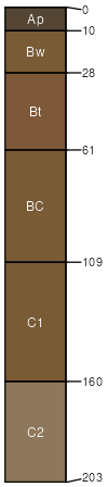
Stonelake
(75%)
Dry Sandy Upland
Typic Udorthents
Excessively drained
Hydric: No
PAWS: 9 cm
outwash plains
moraines / Shoulder
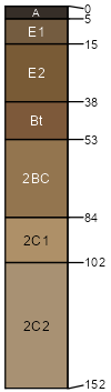
Sanburn
(20%)
Dry Loamy Upland
Inceptic Hapludalfs
Somewhat excessively drained
Hydric: No
PAWS: 9 cm
outwash plains
moraines / Backslope
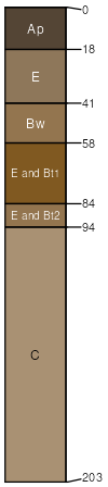
Eagleview
(5%)
Steep Sandy Upland Forest
Lamellic Udipsamments
Somewhat excessively drained
Hydric: No
PAWS: 15 cm
outwash plains / Summit
outwash plains / Shoulder
outwash plains / Backslope
moraines
SSA
Scale
Published
Export
mn009
1:12,000
2007
2025-09-10