Kobase-Rentsac-Megonot complex, 4 to 25 percent slopes
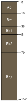
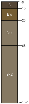
Kobase
(40%)
Clayey (Cy) RRU 58A-C 11-14 p.z.
Torrertic Haplustepts
Well drained
Hydric: No
PAWS: 24 cm
hills / Footslope
hills / Toeslope
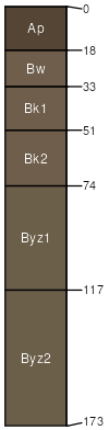
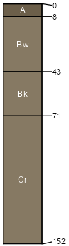
Rentsac
(30%)
Shallow (Sw) RRU 58A-C 11-14 p.z.
Lithic Calciustepts
Well drained
Hydric: No
PAWS: 3 cm
hills / Summit
hills / Shoulder
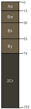
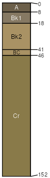
Megonot
(20%)
Silty-Steep (SiStp) RRU 58A-C 11-14 p.z.
Torrertic Haplustepts
Well drained
Hydric: No
PAWS: 10 cm
hills / Backslope
hills / Footslope
Richey
(3%)
Clayey (Cy) RRU 58A-C 11-14 p.z.
Torrertic Haplustolls
Well drained
Hydric: No
PAWS: 23 cm
hills / Toeslope
Yamacall
(3%)
Clayey (Cy) RRU 58A-C 11-14 p.z.
Aridic Haplustepts
Well drained
Hydric: No
PAWS: 24 cm
hills / Toeslope
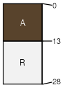
Cabbart
(2%)
Shallow (Sw) RRU 58A-C 11-14 p.z.
Aridic Ustorthents
Well drained
Hydric: No
PAWS: 8 cm
hills / Summit
hills / Backslope
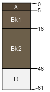
Reedpoint
(1%)
Very Shallow (VSw) RRU 58A-C 11-14 p.z.
Aridic Lithic Haplustolls
Well drained
Hydric: No
PAWS: 1 cm
hills / Summit
hills / Shoulder
Delpoint
(1%)
Silty (Si) RRU 58A-C 11-14 p.z.
Aridic Haplustepts
Well drained
Hydric: No
PAWS: 10 cm
hills / Backslope
hills / Footslope
SSA
Scale
Published
Export
mt669
1:24,000
2025-09-03