Typic Ustorthents-Hickman-Majada association, 1 to 25 percent slopes
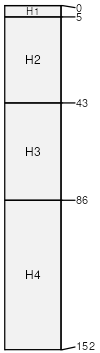
Typic Ustorthents
(31%)
Hills or Elevated Plains 12 to 15 inches
Typic Ustorthents
Well drained
Hydric: No
PAWS: 13 cm
hills / Shoulder
hills / Backslope
hills / Footslope
hills / Toeslope
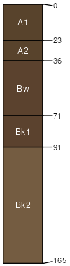
Hickman
(30%)
Swale
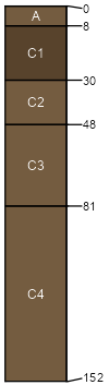
Aridic Ustifluvents
Well drained
Hydric: No
PAWS: 27 cm
drainageways
Majada
(15%)
Basalt Hills
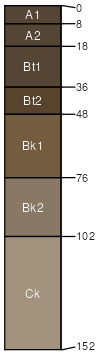
Aridic Argiustolls
Well drained
Hydric: No
PAWS: 13 cm
hills / Shoulder
hills / Backslope
hills / Footslope
hills / Toeslope
Pietown
(10%)
Swale
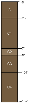
Typic Ustifluvents
Well drained
Hydric: No
PAWS: 18 cm
Manzano
(9%)
Swale
Cumulic Haplustolls
Well drained
Hydric: No
PAWS: 29 cm
Rock outcrop
(5%)
Hydric: No
PAWS: NA
SSA
Scale
Published
Export
nm648
1:48,000
1982
2025-09-09