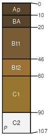
Etowah silt loam, 5 to 12 percent slopes, moderately eroded
Etowah
(90%)
Thermic High And Intermediate Stream Terrace Alluvium
Typic Paleudults
Well drained
Hydric: No
PAWS: 34 cm
terraces / Summit
Mimosa
(4%)
Limestone Uplands
Typic Hapludalfs
Well drained
Hydric: No
PAWS: 20 cm
hillslopes / Backslope
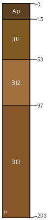
Minvale
(3%)
Thermic Limestone With Interbedded Sedimentary Uplands
Typic Paleudults
Well drained
Hydric: No
PAWS: 23 cm
hillslopes / Toeslope
hillslopes / Footslope
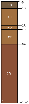
Bewleyville
(3%)
Clayey Limestone Terraces And Uplands
Typic Paleudults
Well drained
Hydric: No
PAWS: 33 cm
hillslopes / Summit
SSA
Scale
Published
Export
tn099
1:20,000
1955
2025-08-28