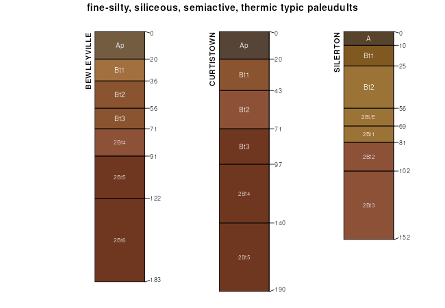
| Bewleyville silt loam, 2 to 6 percent slopes | BeB | 6716 | 328683 | c10p | al033 | 1986 | 1:20000 |
Bewleyville silt loam, 6 to 10 percent slopes | BeC | 2548 | 328684 | c10q | al033 | 1986 | 1:20000 |
Bewleyville silt loam, 2 to 5 percent slopes, moderately eroded | BwB2 | 31673 | 522736 | 318f1 | al083 | 1953 | 1:20000 |
Bewleyville silt loam, 5 to 12 percent slopes, moderately eroded | BwC2 | 2941 | 522737 | 318dz | al083 | 1953 | 1:20000 |
Bewleyville silty clay loam, 5 to 12 percent slopes, severely eroded | BwC3 | 869 | 522732 | 318f0 | al083 | 1953 | 1:20000 |
Bewleyville silt loam, 2 to 5 percent slopes, moderately eroded | BwB2 | 16636 | 523096 | 318f1 | al089 | 1958 | 1:24000 |
Bewleyville silt loam, 5 to 12 percent slopes, moderately eroded | BwC2 | 1165 | 523097 | 318dz | al089 | 1958 | 1:24000 |
Bewleyville silt loam, 6 to 12 percent slopes | BvC | 8540 | 549892 | lg6g | ky171 | 1977 | 1:20000 |
Bewleyville silt loam, 2 to 6 percent slopes | BvB | 6765 | 549891 | lg6f | ky171 | 1977 | 1:20000 |
Bewleyville silt loam, 2 to 6 percent slopes | BeB | 1260 | 549793 | lg38 | ky213 | 1982 | 1:20000 |
Bewleyville silt loam, 6 to 12 percent slopes | BeC | 425 | 549794 | lg39 | ky213 | 1982 | 1:20000 |
Bewleyville silt loam, 2 to 6 percent slopes | BwB | 2551 | 550060 | lgcw | ky231 | 1985 | 1:20000 |
Bewleyville silt loam, 5 to 12 percent slopes, eroded | BeC2 | 1059 | 524405 | klp9 | tn015 | 1999 | 1:24000 |
Bewleyville silt loam, 12 to 20 percent slopes, eroded | BeD2 | 143 | 524406 | klpb | tn015 | 1999 | 1:24000 |
Bewleyville silt loam, 5 to 12 percent slopes, eroded | BeC2 | 2609 | 636846 | pcpf | tn027 | 2002 | 1:24000 |
Bewleyville silt loam, 2 to 5 percent slopes, eroded | BeB2 | 707 | 531070 | ktm9 | tn027 | 2002 | 1:24000 |
Bewleyville silt loam, 5 to 12 percent slopes, eroded | BeC2 | 543 | 530178 | kspj | tn087 | 1999 | 1:24000 |
Bewleyville silt loam, 2 to 5 percent slopes, eroded | BeB2 | 283 | 530177 | ksph | tn087 | 1999 | 1:24000 |
Bewleyville silt loam, 2 to 5 percent slopes, eroded | BtB2 | 5809 | 527626 | 2zpql | tn099 | 1955 | 1:20000 |
Bewleyville silty clay loam, 5 to 12 percent slopes, severely eroded | BtC3 | 1800 | 527629 | 2zpqp | tn099 | 1955 | 1:20000 |
Bewleyville silt loam, 5 to 12 percent slopes, eroded | BtC2 | 1629 | 527628 | 2zpqm | tn099 | 1955 | 1:20000 |
Bewleyville silt loam, 2 to 5 percent slopes | BtB | 826 | 527625 | 2zpqk | tn099 | 1955 | 1:20000 |
Bewleyville silt loam, 5 to 12 percent slopes | BtC | 412 | 527627 | 2zpqn | tn099 | 1955 | 1:20000 |
Bewleyville silt loam, 2 to 5 percent slopes | BwB | 4294 | 525819 | kn4x | tn103 | 1999 | 1:24000 |
Bewleyville silt loam, 5 to 12 percent slopes | BwC | 1070 | 525820 | kn4y | tn103 | 1999 | 1:24000 |
Bewleyville silt loam, 2 to 5 percent slopes, eroded | BeB2 | 3029 | 527693 | kq3c | tn111 | 1992 | 1:24000 |
Bewleyville silt loam, 5 to 12 percent slopes, eroded | BeC2 | 1217 | 527694 | kq3d | tn111 | 1992 | 1:24000 |
Bewleyville silt loam, 5 to 12 percent slopes, eroded | BeC2 | 1481 | 843360 | x9l5 | tn133 | 2003 | 1:24000 |
Bewleyville silt loam, 2 to 5 percent slopes, eroded | BeB2 | 328 | 843359 | x9l4 | tn133 | 2003 | 1:24000 |
Bewleyville silt loam, 2 to 5 percent slopes, eroded | Cc | 595 | 2396894 | 2lg55 | tn161 | 1953 | 1:20000 |
Bewleyville silt loam, 5 to 12 percent slopes, eroded | Cb | 494 | 2396893 | 2lg54 | tn161 | 1953 | 1:20000 |
Bewleyville silty clay loam, 2 to 5 percent slopes, eroded | BeB2 | 11492 | 528345 | kqsd | tn165 | 1993 | 1:20000 |
Bewleyville silty clay loam, 5 to 12 percent slopes, eroded | BeC2 | 4244 | 528346 | kqsf | tn165 | 1993 | 1:20000 |
Bewleyville silt loam, 2 to 5 percent slopes, eroded | BeB2 | 796 | 528445 | kqwm | tn189 | 1988 | 1:20000 |
Bewleyville silt loam, 5 to 12 percent slopes, eroded | BeC2 | 702 | 528446 | kqwn | tn189 | 1988 | 1:20000 |
Bewleyville silt loam, 2 to 5 percent slopes | BeB | 4382 | 528629 | kr2k | tn604 | 1974 | 1:20000 |
Bewleyville silt loam, 5 to 12 percent slopes | BeC | 3519 | 528630 | kr2l | tn604 | 1974 | 1:20000 |
Bewleyville silt loam, 5 to 12 percent slopes, eroded | BeC2 | 6898 | 2427402 | 2mgx9 | tn610 | 1960 | 1:15840 |
Bewleyville silt loam, 2 to 5 percent slopes | BeB | 3216 | 2427400 | 2mgx7 | tn610 | 1960 | 1:15840 |
Bewleyville silty clay loam, 5 to 12 percent slopes, severely eroded | BmC3 | 1666 | 2427404 | 2mgxc | tn610 | 1960 | 1:15840 |
Bewleyville silt loam, 5 to 12 percent slopes | BeC | 743 | 2427401 | 2mgx8 | tn610 | 1960 | 1:15840 |
Bewleyville silt loam, 12 to 20 percent slopes, eroded | BeD2 | 542 | 2427403 | 2mgxb | tn610 | 1960 | 1:15840 |
Bewleyville silty clay loam, 12 to 20 percent slopes, severely eroded | BmD3 | 358 | 2427405 | 2mgxd | tn610 | 1960 | 1:15840 |
Bewleyville-Dickson complex, 2 to 6 percent slopes | BeB | 3100 | 2439166 | 2mw4s | tn701 | 1985 | 1:24000 |
