Troutdale (45%)
Pine Grasslands
Ustic Argicryolls
Well drained
Hydric: No
PAWS: 8 cm |
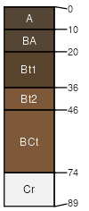
mountain slopes / Backslope ridges
|
|
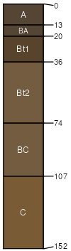
Sprucedale (40%)
Pine Grasslands
Ustic Argicryolls
Well drained
Hydric: No
PAWS: 3 cm |
mountain slopes / Shoulder ridges
|
|
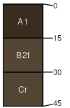
Rogert (4%)
Lithic Haplocryolls
Well drained
Hydric: No
PAWS: 2 cm |
|
|
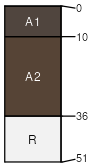
Kittredge (4%)
Ustic Argicryolls
Well drained
Hydric: No
PAWS: 21 cm |
|
|
Rock outcrop (3%)
Hydric: No
PAWS: 0 cm |

cliffs mountain slopes / Shoulder mountain slopes / Backslope ridges
|
|
Urban land (2%)
Hydric: No
PAWS: 0 cm |
mountain slopes / Footslope mountain slopes / Toeslope alluvial fans
|
|
Cumulic Cryaquolls (2%)
Mountain Meadow
Cumulic Cryaquolls
Poorly drained
Hydric: Yes
PAWS: 12 cm |

|
|