Badland-Wentridge complex, 50 to 80 percent slopes
Badland
(45%)
Hydric: No
PAWS: 0 cm
ridges
hills
erosion remnants
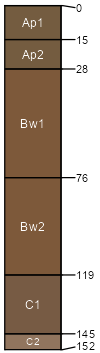
Wentridge
(40%)
Desert Very Steep Shallow Loam (Shadscale)
Typic Torriorthents
Well drained
Hydric: No
PAWS: 9 cm
hills
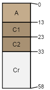
Turzo
(3%)
Desert Loam (Shadscale)
Hydric: No
PAWS: NA
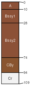
Gerst
(3%)
Semidesert Shallow Loam (Utah Juniper-Pinyon)
Hydric: No
PAWS: NA
Rock outcrop
(3%)
Hydric: No
PAWS: NA
Denco
(3%)
Desert Shallow Clay (Mat Saltbush)
Hydric: No
PAWS: NA
Mespun
(3%)
Hydric: No
PAWS: NA
SSA
Scale
Published
Export
ut047
1:24,000
1999
2025-09-05