Chipenhill-Rock outcrop complex, 15 to 30 percent slopes
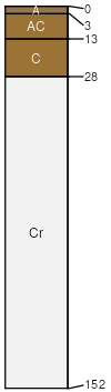
Chipenhill
(55%)
Shale High Plains Southeast (Sh)
Typic Torriorthents
Well drained
Hydric: No
PAWS: 3 cm
hills / Backslope
Rock outcrop
(30%)
Hydric: No
PAWS: 0 cm
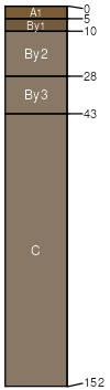
Chipendale
(10%)
Saline Upland High Plains Southeast (SU)
Leptic Haplogypsids
Well drained
Hydric: No
PAWS: 21 cm
hills / Backslope
hills / Footslope
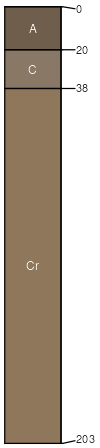
Tassel
(5%)
Shallow Sandy (SwSy) 10-14 PZ
Ustic Torriorthents
Well drained
Hydric: No
PAWS: 5 cm
hills / Backslope
hills / Shoulder
hills / Summit
SSA
Scale
Published
Export
wy625
1:24,000
1985
2025-09-04