Stapleton-Bresser association
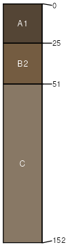
Stapleton
(60%)
Sandy Foothill
Aridic Haplustolls
Well drained
Hydric: No
PAWS: 15 cm
ridges
knobs
valley sides
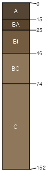
Bresser
(25%)
Sandy Foothill
Aridic Argiustolls
Well drained
Hydric: No
PAWS: 19 cm
Loamy alluvial land
(14%)
Hydric: No
PAWS: NA
Aquic Haplustolls
(1%)
Hydric: Yes
PAWS: NA
swales
SSA
Scale
Published
Export
co622
1:20,000
1968
2025-08-29