Official Series Description


Lab Data Summary

Aggregate lab data for the BRESSER soil series. This aggregation is based on all pedons with a current taxon name of BRESSER, and applied along 1-cm thick depth slices. Solid lines are the slice-wise median, bounded on either side by the interval defined by the slice-wise 5th and 95th percentiles. The median is the value that splits the data in half. Five percent of the data are less than the 5th percentile, and five percent of the data are greater than the 95th percentile. Values along the right hand side y-axis describe the proportion of pedon data that contribute to aggregate values at this depth. For example, a value of "90%" at 25cm means that 90% of the pedons correlated to BRESSER were used in the calculation. Source: KSSL snapshot . Methods used to assemble the KSSL snapshot used by SoilWeb / SDE

Click the image to view it full size.

Pedons used in the lab summary:

MLRALab IDPedon IDTaxonnameCINSSL / NASIS ReportsLink To SoilWeb GMap
67B07N012607CO087005Bresser7Primary | Supplementary | Taxonomy | Pedon | Water Retention | Correlation | Andic Soil Properties40.1540833,-104.0451355
67B08N009308CO087002Bresser8Primary | Supplementary | Taxonomy | Pedon | Water Retention | Correlation | Andic Soil Properties40.2003889,-103.8065278
67B40A3841S1961CO005009Bresser6Primary | Supplementary | Taxonomy | Pedon | Water Retention | Correlation | Andic Soil Properties39.6849976,-104.1822128
67B40A3842S1961CO005010Bresser6Primary | Supplementary | Taxonomy | Pedon | Water Retention | Correlation | Andic Soil Properties39.6080551,-104.2136078

Water Balance

Monthly water balance estimated using a leaky-bucket style model for the BRESSER soil series. Monthly precipitation (PPT) and potential evapotranspiration (PET) have been estimated from the 50th percentile of gridded values (PRISM 1981-2010) overlapping with the extent of SSURGO map units containing each series as a major component. Monthly PET values were estimated using the method of Thornthwaite (1948). These (and other) climatic parameters are calculated with each SSURGO refresh and provided by the fetchOSD function of the soilDB package. Representative water storage values (“AWC” in the figures) were derived from SSURGO by taking the 50th percentile of profile-total water storage (sum[awc_r * horizon thickness]) for each soil series. Note that this representation of “water storage” is based on the average ability of most plants to extract soil water between 15 bar (“permanent wilting point”) and 1/3 bar (“field capacity”) matric potential. Soil moisture state can be roughly interpreted as “dry” when storage is depleted, “moist” when storage is between 0mm and AWC, and “wet” when there is a surplus. Clearly there are a lot of assumptions baked into this kind of monthly water balance. This is still a work in progress.

Click the image to view it full size.


Click the image to view it full size.

Sibling Summary

Siblings are those soil series that occur together in map units, in this case with the BRESSER series. Sketches are arranged according to their subgroup-level taxonomic structure. Source: SSURGO snapshot , parsed OSD records and snapshot of SC database .

Click the image to view it full size.

Select annual climate data summaries for the BRESSER series and siblings. Series are sorted according to hierarchical clustering of median values. Source: SSURGO map unit geometry and 1981-2010, 800m PRISM data .

Click the image to view it full size.

Geomorphic description summaries for the BRESSER series and siblings. Series are sorted according to hierarchical clustering of proportions and relative hydrologic position within an idealized landform (e.g. top to bottom). Most soil series (SSURGO components) are associated with a hillslope position and one or more landform-specific positions: hills, mountain slopes, terraces, and/or flats. Proportions can be interpreted as an aggregate representation of geomorphic membership. The values printed to the left (number of component records) and right (Shannon entropy) of stacked bars can be used to judge the reliability of trends. Small Shannon entropy values suggest relatively consistent geomorphic association, while larger values suggest lack thereof. Source: SSURGO component records .

Click the image to view it full size.

Click the image to view it full size.

There are insufficient data to create the 3D mountains figure.

Click the image to view it full size.

Click the image to view it full size.

Competing Series

Soil series competing with BRESSER share the same family level classification in Soil Taxonomy. Source: parsed OSD records and snapshot of the SC database .

Click the image to view it full size.

Select annual climate data summaries for the BRESSER series and competing. Series are sorted according to hierarchical clustering of median values. Source: SSURGO map unit geometry and 1981-2010, 800m PRISM data .

Click the image to view it full size.

Geomorphic description summaries for the BRESSER series and competing. Series are sorted according to hierarchical clustering of proportions and relative hydrologic position within an idealized landform (e.g. top to bottom). Proportions can be interpreted as an aggregate representation of geomorphic membership. Most soil series (SSURGO components) are associated with a hillslope position and one or more landform-specific positions: hills, mountain slopes, terraces, and/or flats. The values printed to the left (number of component records) and right (Shannon entropy) of stacked bars can be used to judge the reliability of trends. Shannon entropy values close to 0 represent soil series with relatively consistent geomorphic association, while values close to 1 suggest lack thereof. Source: SSURGO component records .

Click the image to view it full size.

Click the image to view it full size.

Click the image to view it full size.

Click the image to view it full size.

Click the image to view it full size.

Soil series sharing subgroup-level classification with BRESSER, arranged according to family differentiae. Hovering over a series name will print full classification and a small sketch from the OSD. Source: snapshot of SC database .

Block Diagrams

No block diagrams are available.

Map Units

Map units containing BRESSER as a major component. Limited to 250 records.

Map Unit Name Symbol Map Unit Area (ac) Map Unit Key National Map Unit Symbol Soil Survey Area Publication Date Map Scale
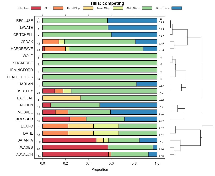
Nunn-Bresser-Ascalon complex, 0 to 3 percent slopesNrB506509414334ywco00519711:20000
Bresser-Truckton sandy loams, 3 to 5 percent slopesBvC296959412134y5co00519711:20000
Bresser-Truckton sandy loams, 5 to 20 percent slopesBvE172649412234y6co00519711:20000
Bresser-Stapleton sandy loams, 9 to 20 percent slopesBuE92569412034y4co00519711:20000
Bresser and Truckton soil, 3 to 9 slopes, erodedBwD278349412334y7co00519711:20000
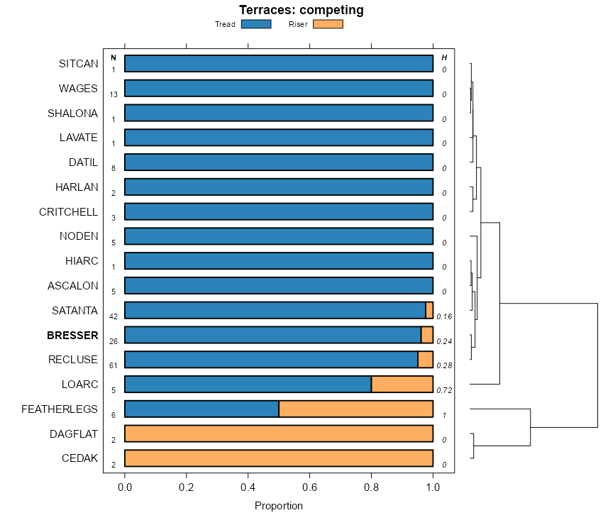
Bresser sandy loam, terrace, 0 to 3 percent slopesBsB38339411734y1co00519711:20000
Bresser-Stapleton sandy loams, 3 to 9 percent slopesBuD10249411934y3co00519711:20000
Bresser loamy sand, 0 to 3 percent slopesBrB345941162swl2co00519711:20000
Bresser sandy loam, 1 to 5 percent slopes11779181051983jghco07320011:24000
Bresser sandy loam, 0 to 3 percent slopesBvA193471103982swl0co08719651:24000
Bresser loamy sand, 0 to 3 percent slopesBuA83681103962swl2co08719651:24000
Bresser clay loam, terrace, 0 to 1 percent slopesBtA51141103953pw4co08719651:24000
Bresser soils, terrace, 3 to 5 percent slopesBxC8751104023pwcco08719651:24000
Bresser loamy sand, terrace, 1 to 3 percent slopesBuB211103973pw6co08719651:24000
Bresser sandy loam, 0 to 3 percent slopes1521619510535yxco61719801:24000
Bresser sandy loam, 3 to 9 percent slopes1618119510635yyco61719801:24000
Bresser sandy loam, 0 to 3 percent slopes112166951882swl0co61819761:24000
Bresser-Truckton sandy loams, 5 to 25 percent slopesBtE16332498706jqy9co62219681:20000
Stapleton-Bresser associationSt9358498768jr09co62219681:20000
Bresser sandy loam, cool, 5 to 9 percent slopesBrD65584987042tlpkco62219681:20000
Bresser sandy loam, cool, 1 to 3 percent slopesBrB38944987032tlpjco62219681:20000
Bresser-Louviers complex, 7 to 30 percent slopesBsE1605498705jqy8co62219681:20000
Bresser and Truckton soils, 3 to 12 percent slopes, erodedBuD21409498707jqybco62219681:20000
Bresser sandy loam, cool, 5 to 9 percent slopes61138364964392tlpkco62319771:24000
Bresser-Truckton sandy loams, 8 to 25 percent slopes968696496442jnl8co62319771:24000
Bresser sandy loam, 0 to 4 percent slopes521828496438jnl4co62319771:24000
Bresser-Stapleton sandy loams, 8 to 25 percent slopes819693496441jnl7co62319771:24000
Bresser-Cushman complex, 4 to 20 percent slopes714011496440jnl6co62319771:24000
Bresser-Truckton-Blakeland complex, 3 to 9 percent slopesBtD44318952902xst2co62419631:20000
Bresser sandy loam, cool, 0 to 3 percent slopesBlB509629920392tlphco62419631:20000
Truckton, Bresser, and Blakeland soils, 5 to 20 percent slopes, erodedTrE2405595338366fco62419631:20000
Bresser sandy loam, 1 to 3 percent slopesBmB248795285364qco62419631:20000
Bresser sandy loam, 3 to 5 percent slopesBmC2071952862tlpfco62419631:20000
Bresser sandy loam, 5 to 9 percent slopesBmD137195287364sco62419631:20000
Bresser sandy loam, cool, 3 to 5 percent slopesBnC100829920782tlpdco62419631:20000
Bresser complex, 3 to 5 percent slopes, erodedBrC253595289364vco62419631:20000
Bresser sandy loam, 9 to 15 percent slopesBmE28395288364tco62419631:20000
Bresser sandy loam, cool, 3 to 5 percent slopes1242891953702tlpdco62519751:24000
Bresser sandy loam, cool, 0 to 3 percent slopes1125642953682tlphco62519751:24000
Truckton-Bresser complex, eroded10010173953583672co62519751:24000
Bresser sandy loam, cool, 5 to 9 percent slopes137408953712tlpkco62519751:24000
Truckton-Bresser sandy loams, 5 to 20 percent slopes996430954652yvrpco62519751:24000
Bresser sandy loam, 0 to 5 percent slopes15343497429jpm3co64119801:24000
Bresser gravelly sandy loam, 9 to 25 percent slopes16173497440jpmgco64119801:24000
Bresser sandy loam, 0 to 3 percent slopes1202241049213j5kwy72119941:24000

Map of Series Extent

Approximate geographic distribution of the BRESSER soil series. To learn more about how this distribution was mapped, or to compare this soil series extent to others, use the Series Extent Explorer (SEE) application. Source: generalization of SSURGO geometry .