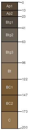
Stronghurst silt loam, loamy substratum, 0 to 3 percent slopes
Stronghurst
(90%)
Moist Loamy or Clayey Lowland
Aeric Endoaqualfs
Somewhat poorly drained
Hydric: No
PAWS: 30 cm
drainageways
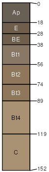
Fayette
(7%)
Loamy and Clayey Upland
Typic Hapludalfs
Well drained
Hydric: No
PAWS: 29 cm
till plains
till plains / Summit
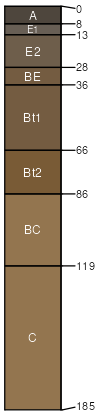
Brookston
(3%)
Wet Loamy or Clayey Lowland
Typic Argiaquolls
Very poorly drained
Hydric: Yes
PAWS: 25 cm
glacial-valley floors / Toeslope
depressions / Toeslope
SSA
Scale
Published
Export
wi045
1:12,000
1969
2025-09-10