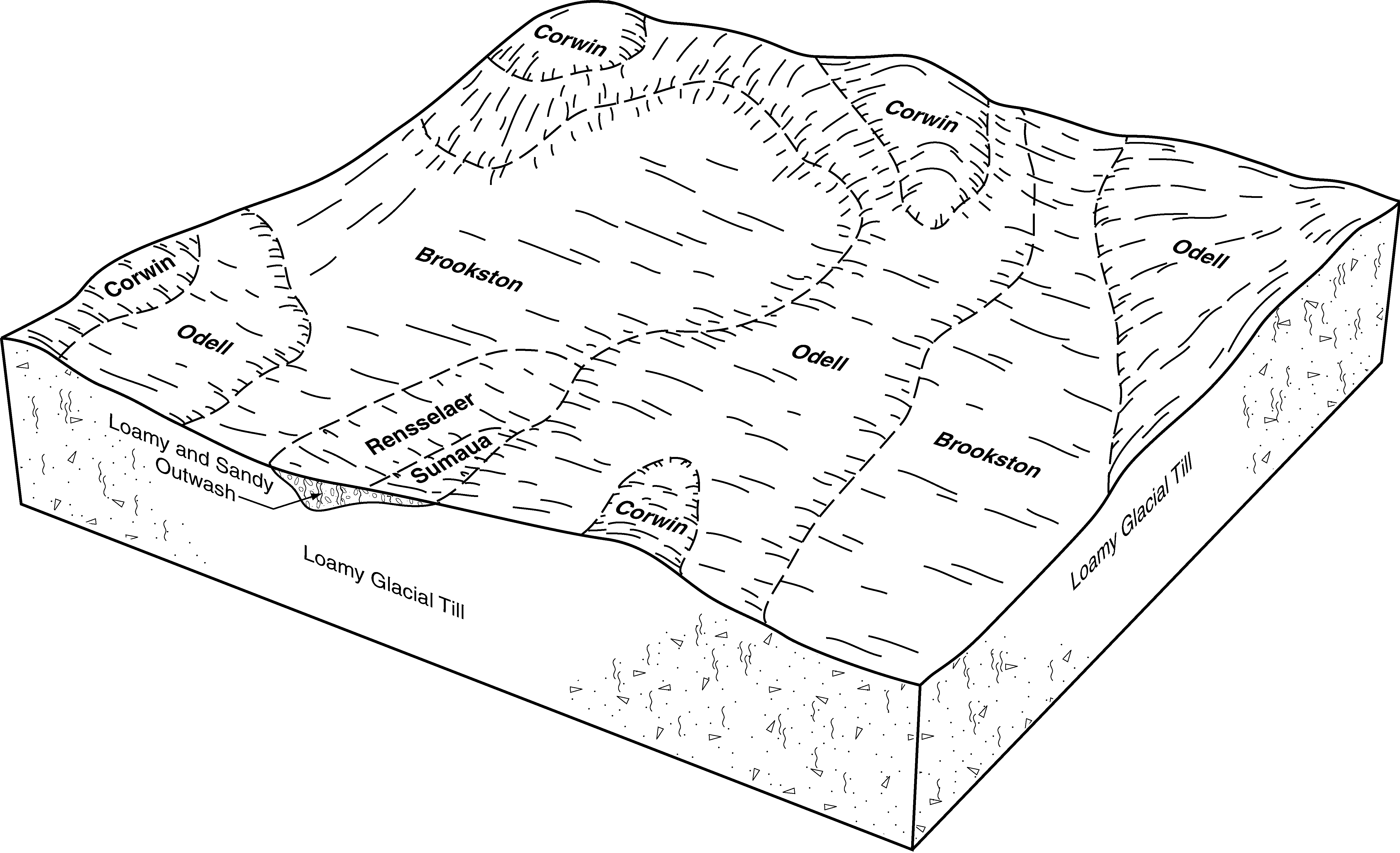
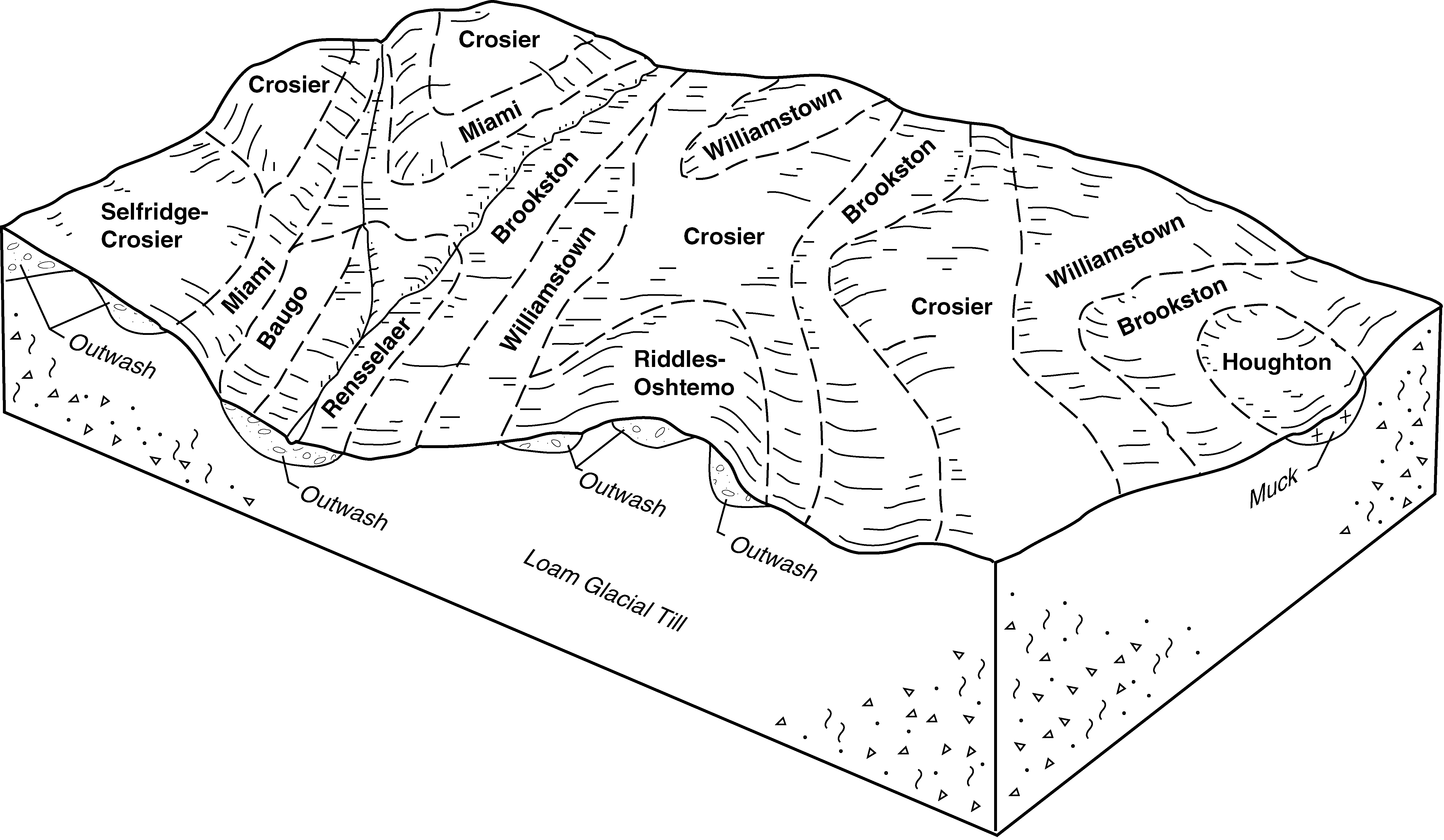
| Brookston silty clay loam | Bs | 223 | 164674 | 5jc2 | in003 | 1965 | 1:15840 |
Brookston silt loam | Br | 178 | 164673 | 5jc1 | in003 | 1965 | 1:15840 |
Brookston-Urban land complex | YbbA | 136 | 3404503 | 2zy33 | in003 | 1965 | 1:15840 |
Brookston loam, 0 to 1 percent slopes | BuuA | 18088 | 165330 | 5k17 | in039 | 1997 | 1:12000 |
Brookston silty clay loam, 0 to 2 percent slopes | By | 6166 | 1612809 | 2t98n | in041 | 1958 | 1:15840 |
Brookston silt loam, 0 to 2 percent slopes | Br | 833 | 1612808 | 2w571 | in041 | 1958 | 1:15840 |
Brookston silty clay loam, 0 to 2 percent slopes | Br | 37370 | 3186658 | 2t98n | in057 | 1976 | 1:15840 |
Brookston silty clay loam-Urban land complex, 0 to 2 percent slopes | YbvA | 15441 | 3105085 | 2w57n | in057 | 1976 | 1:15840 |
Urban land-Brookston complex, 0 to 2 percent slopes | UbaA | 1913 | 3105084 | 2y48h | in057 | 1976 | 1:15840 |
Brookston silty clay loam, 0 to 2 percent slopes | Br | 60587 | 160821 | 2t98n | in059 | 1974 | 1:15840 |
Brookston silty clay loam-Urban land complex, 0 to 2 percent slopes | YbvA | 974 | 3105129 | 2w57n | in059 | 1974 | 1:15840 |
Brookston silty clay loam-Urban land complex, 0 to 2 percent slopes | YbvA | 7905 | 3105178 | 2w57n | in063 | 1971 | 1:15840 |
Urban land-Brookston complex, 0 to 2 percent slopes | UbaA | 1993 | 3105177 | 2y48h | in063 | 1971 | 1:15840 |
Brookston silty clay loam, 0 to 2 percent slopes | Bs | 1853 | 3104622 | 2t98n | in063 | 1971 | 1:15840 |
Brookston silt loam, overwash, 0 to 2 percent slopes | Br | 109 | 3104621 | 2w56w | in063 | 1971 | 1:15840 |
Brookston silt loam, overwash-Urban land complex, 0 to 2 percent slopes | YbwA | 4 | 3105176 | 2xf6w | in063 | 1971 | 1:15840 |
Brookston silty clay loam, 0 to 2 percent slopes | Bs | 28358 | 161442 | 2t98n | in067 | 1967 | 1:20000 |
Brookston loam | Br | 4140 | 161346 | 5dwq | in073 | 1985 | 1:15840 |
Brookston silty clay loam, 0 to 2 percent slopes | Br | 28347 | 161657 | 2t98n | in081 | 1975 | 1:15840 |
Brookston silty clay loam-Urban land complex, 0 to 2 percent slopes | YbvA | 4799 | 3105223 | 2w57n | in081 | 1975 | 1:15840 |
Urban land-Brookston complex, 0 to 2 percent slopes | UbaA | 1348 | 3105222 | 2y48h | in081 | 1975 | 1:15840 |
Brookston silty clay loam, 0 to 2 percent slopes | Bs | 34421 | 162062 | 2t98n | in095 | 1965 | 1:15840 |
Brookston silty clay loam-Urban land complex, 0 to 2 percent slopes | YbvA | 22302 | 3104674 | 2w57n | in097 | 1975 | 1:15840 |
Urban land-Brookston complex, 0 to 2 percent slopes | UbaA | 6218 | 3104673 | 2y48h | in097 | 1975 | 1:15840 |
Brookston-Urban land complex, 0 to 2 percent slopes | YbcA | 3282 | 3104710 | 2xf71 | in097 | 1975 | 1:15840 |
Brookston loam, 0 to 1 percent slopes | BuuA | 20880 | 1702542 | 1v4mq | in099 | 1978 | 1:15840 |
Urban land-Brookston complex, 0 to 1 percent slopes | UfbA | 167 | 2495706 | 2qnfd | in099 | 1978 | 1:15840 |
Brookston loam | Br | 4961 | 161954 | 5fjb | in103 | 1977 | 1:20000 |
Brookston clay loam | Br | 546 | 3105051 | 5gth | in109 | 1979 | 1:15840 |
Brookston clay loam-Urban land complex, 0 to 2 percent slopes | YblA | 235 | 3104782 | 2xf6x | in109 | 1979 | 1:15840 |
Brookston silt loam | Bx | 9883 | 272521 | 94l0 | in113 | 1974 | 1:15840 |
Brookston loam, 0 to 1 percent slopes | BuuA | 21562 | 184927 | 66fd | in131 | 2001 | 1:12000 |
Brookston-Navunon loams, 0 to 1 percent slopes | BuzA | 9737 | 184921 | 66f6 | in131 | 2001 | 1:12000 |
Brookston loam, 0 to 1 percent slopes | BuuA | 21770 | 200283 | 6qdr | in141 | 2001 | 1:12000 |
Urban land-Brookston complex, 0 to 1 percent slopes | UfbA | 13 | 625291 | nznp | in141 | 2001 | 1:12000 |
Brookston silty clay loam, 0 to 2 percent slopes | Br | 43799 | 160706 | 2t98n | in145 | 1968 | 1:15840 |
Westland and Brookston loams, overwash | We | 789 | 160760 | 5d8t | in145 | 1968 | 1:15840 |
Brookston loam | Bz | 4031 | 160188 | 5cpc | in151 | 1979 | 1:20000 |
Brookston silty clay loam, 0 to 2 percent slopes | By | 3417 | 1612958 | 2t98n | in161 | 1958 | 1:15840 |
Brookston silt loam, 0 to 2 percent slopes | Br | 100 | 1612957 | 2w571 | in161 | 1958 | 1:15840 |
Brookston loam | Br | 8653 | 161161 | 5dpr | in169 | 1980 | 1:15840 |
Brookston loam | Bz | 596 | 161772 | 5fbg | in183 | 1985 | 1:15840 |
Brookston loam, 0 to 2 percent slopes | 17 | 2907 | 212440 | 2w64l | mi005 | 1984 | 1:15840 |
Belleville-Brookston complex | 64 | 2015 | 212482 | 7438 | mi005 | 1984 | 1:15840 |
Brookston loam, 0 to 2 percent slopes | Bw | 43 | 2437907 | 2w64l | mi037 | 1974 | 1:15840 |
Brookston loam, 0 to 2 percent slopes | Bw | 13895 | 186831 | 2w64l | mi049 | 1967 | 1:20000 |
Brookston loam, dense substratum, 0 to 1 percent slopes | BroaaA | 13452 | 2386582 | 2w64m | mi049 | 1967 | 1:20000 |
Colwood-Brookston loams | Co | 35443 | 186725 | 689d | mi065 | 1977 | 1:15840 |
Brookston loam, 0 to 2 percent slopes | Bw | 807 | 2437779 | 2w64l | mi065 | 1977 | 1:15840 |
Brookston loam | Bw | 10752 | 191999 | 6fsj | mi087 | 1966 | 1:15840 |
Brookston and Colwood loams | Bx | 50 | 2673664 | 6bgq | mi087 | 1966 | 1:15840 |
Brookston loam, overwashed, 0 to 3 percent slopes | BpA | 5384 | 188447 | 6b2y | mi091 | 1957 | 1:20000 |
Brookston loam, 0 to 3 percent slopes | BoA | 2323 | 188446 | 6b2x | mi091 | 1957 | 1:20000 |
Brookston loam | Br | 5 | 2508726 | 6fd3 | mi091 | 1957 | 1:20000 |
Brookston loam, 0 to 2 percent slopes | By | 6772 | 187548 | 2w64l | mi093 | 1968 | 1:20000 |
Brookston loam | 61 | 3100 | 187266 | 68vv | mi115 | 1980 | 1:15840 |
Brookston and Colwood loams | 12 | 9773 | 188812 | 6bgq | mi125 | 1980 | 1:15840 |
Brookston loam | 102 | 17 | 2420085 | 2m798 | mi125 | 1980 | 1:15840 |
Brookston loam, 0 to 2 percent slopes | 105 | 4574 | 2422501 | 2w64l | mi145 | 1991 | 1:15840 |
Brookston loam | Bw | 4103 | 2508329 | 6fsj | mi147 | 1969 | 1:20000 |
Brookston loam | Bw | 7 | 2508253 | 6fsj | mi151 | 1955 | 1:15840 |
Brookston loam, dense substratum, 0 to 1 percent slopes | BroaaA | 32263 | 2393950 | 2w64m | mi155 | 1967 | 1:12000 |
Brookston loam, 0 to 2 percent slopes | Bw | 30809 | 187783 | 2w64l | mi155 | 1967 | 1:12000 |
Brookston loam, 0 to 2 percent slopes | 105 | 19 | 2423854 | 2w64l | mi157 | 1984 | 1:15840 |
Brookston loam | Br | 9459 | 191614 | 6fd3 | mi161 | 1974 | 1:20000 |
Conover-Brookston loams, 0 to 2 percent slopes | CpA | 4286 | 191617 | 6fd6 | mi161 | 1974 | 1:20000 |
Brookston silty clay loam, fine texture, 0 to 2 percent slopes | BsA | 30960 | 171419 | 2t98m | oh021 | 1966 | 1:15840 |
Brookston silty clay loam, 2 to 6 percent slopes | BsB | 2546 | 171420 | 5rcp | oh021 | 1966 | 1:15840 |
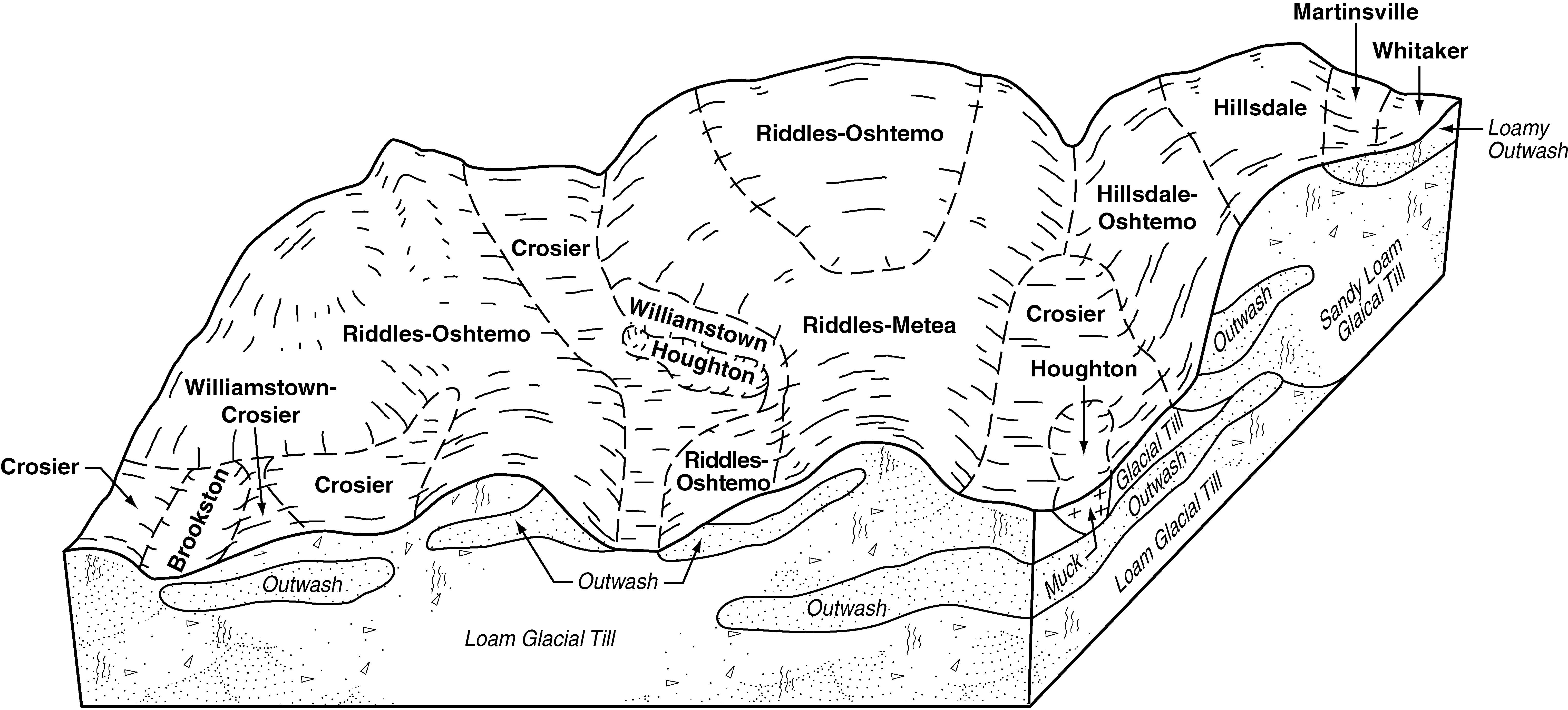
Brookston silty clay loam, fine texture, 0 to 2 percent slopes | Br | 55751 | 168490 | 2t98m | oh037 | 1984 | 1:15840 |
Brookston silty clay loam, fine texture, 0 to 2 percent slopes | Bs | 90020 | 169220 | 2t98m | oh047 | 1968 | 1:15840 |
Brookston silty clay loam, fine texture, 0 to 2 percent slopes | Bs | 15754 | 169281 | 2t98m | oh057 | 1974 | 1:15840 |
Brookston-Urban land complex | Bt | 157 | 169282 | 5p4q | oh057 | 1974 | 1:15840 |
Brookston silty clay loam, fine-silty, 0 to 2 percent slopes | Bt | 3787 | 1420378 | 2t98l | oh071 | 1973 | 1:15840 |
Brookston silt loam, fine-silty, 0 to 2 percent slopes | Bs | 2892 | 1420377 | 2vzcy | oh071 | 1973 | 1:15840 |
Brookston silty clay loam, fine texture, 0 to 2 percent slopes | Bs | 4073 | 171097 | 2t98m | oh091 | 1977 | 1:15840 |
Brookston silty clay loam, fine texture, 0 to 2 percent slopes | Bs | 871 | 1402801 | 2t98m | oh097 | 1978 | 1:15840 |
Brookston silty clay loam, fine texture, 0 to 2 percent slopes | Bs | 36028 | 169469 | 2t98m | oh109 | 1973 | 1:15840 |
Brookston silty clay loam, fine texture, 0 to 2 percent slopes | Bs | 34066 | 170228 | 2t98m | oh113 | 1969 | 1:15840 |
Brookston silt loam, fine subsoil, 0 to 2 percent slopes | Bp | 8529 | 170226 | 2w56r | oh113 | 1969 | 1:15840 |
Brookston-Urban land complex | Bu | 1240 | 170229 | 5q48 | oh113 | 1969 | 1:15840 |
Brookston silt loam, overwash, fine subsoil, 0 to 2 percent slopes | Br | 889 | 170227 | 2w56s | oh113 | 1969 | 1:15840 |
Brookston silty clay loam, fine texture, 0 to 2 percent slopes | Bs | 11048 | 170024 | 2t98m | oh149 | 1977 | 1:15840 |
Brookston, fine texture-Urban land complex, 0 to 2 percent slopes | BuA | 27 | 3216928 | 2z6b4 | oh149 | 1977 | 1:15840 |
Urban land-Brookston, fine texture complex, 0 to 2 percent slopes | UbA | 24 | 3216954 | 2z6b5 | oh149 | 1977 | 1:15840 |
Brookston silty clay loam, fine texture, 0 to 2 percent slopes | Bs | 17685 | 1406060 | 2t98m | oh159 | 1970 | 1:15840 |
Brookston silty clay loam, fine-silty, 0 to 2 percent slopes | Br | 5811 | 171320 | 2t98l | oh165 | 1967 | 1:20000 |
Brookston, fine-silty-Urban land complex, 0 to 2 percent slopes | BrU | 2738 | 3422226 | 31ghf | oh165 | 1967 | 1:20000 |
Urban land-Brookston, fine-silty, complex, 0 to 2 percent slopes | UBr | 482 | 3422227 | 31ghg | oh165 | 1967 | 1:20000 |
Brookston silt loam, 0 to 2 percent slopes | 7340A | 1299 | 3268468 | 2tjx5 | wi015 | 2023 | 1:15840 |
Brookston silt loam, 0 to 2 percent slopes | 7340A | 3585 | 423553 | 2tjx5 | wi027 | 1976 | 1:15840 |
Brookston silt loam, 0 to 2 percent slopes | 7340A | 5750 | 425405 | 2tjx5 | wi039 | 1967 | 1:15840 |
Brookston silty clay loam, 0 to 3 percent slopes | 7344A | 944 | 425407 | g8nt | wi039 | 1967 | 1:15840 |
Brookston stony silt loam, 0 to 3 percent slopes | 7342A | 676 | 425406 | g8ns | wi039 | 1967 | 1:15840 |
Brookston silt loam, 0 to 2 percent slopes | 7340A | 410 | 425207 | 2tjx5 | wi045 | 1969 | 1:12000 |
Brookston silt loam, 0 to 2 percent slopes | 7340A | 3796 | 3268531 | 2tjx5 | wi071 | 2023 | 1:15840 |
Brookston silt loam, 0 to 2 percent slopes | 7340A | 842 | 425950 | 2tjx5 | wi089 | 1967 | 1:15840 |
Brookston silt loam, 0 to 2 percent slopes | 7340A | 2335 | 426277 | 2tjx5 | wi105 | 1970 | 1:20000 |
Brookston silt loam, 0 to 2 percent slopes | 7340A | 6109 | 425703 | 2tjx5 | wi131 | 1967 | 1:15840 |
Brookston silt loam, 0 to 2 percent slopes | 7340A | 5300 | 3403451 | 2tjx5 | wi133 | 2023 | 1:15840 |