Northfield sandy loam, 30 to 45 percent slopes
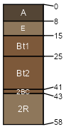
Northfield
(85%)
Shallow Loamy-Silty Upland
Lithic Dystrudepts
Well drained
Hydric: No
PAWS: 7 cm
hills
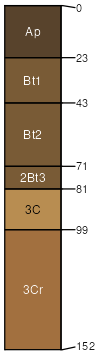
Hixton
(7%)
Shallow Loamy-Silty Upland
Typic Hapludalfs
Well drained
Hydric: No
PAWS: 13 cm
valley sides
hills / Backslope
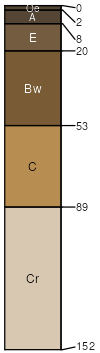
Boone
(5%)
Dry Upland
Typic Quartzipsamments
Excessively drained
Hydric: No
PAWS: 8 cm
ridges / Backslope
Rock outcrop
(3%)
Hydric: No
PAWS: NA
valley sides / Shoulder
SSA
Scale
Published
Export
wi065
1:16,000
1964
2025-09-10