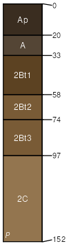
Griswold silt loam, 12 to 20 percent slopes, eroded
Griswold
(94%)
Loamy and Clayey Upland
Mollic Hapludalfs
Well drained
Hydric: No
PAWS: 29 cm
moraines / Summit
moraines / Backslope
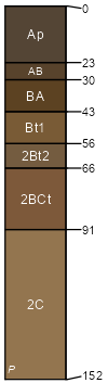
Ringwood
(4%)
Loamy and Clayey Upland
Typic Argiudolls
Well drained
Hydric: No
PAWS: 28 cm
moraines / Summit
moraines / Shoulder
moraines / Backslope
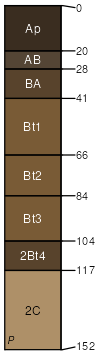
Plano
(2%)
Loamy and Clayey Upland
Mollic Hapludalfs
Well drained
Hydric: No
PAWS: 33 cm
moraines / Backslope
SSA
Scale
Published
Export
wi021
1:16,000
1972
2025-09-10