Rockton (90%)
Loamy Bedrock Upland
Typic Argiudolls
Well drained
Hydric: No
PAWS: 19 cm |
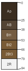
hills / Shoulder hills / Backslope
|
|
Ritchey (5%)
Loamy Bedrock Upland
Lithic Hapludalfs
Well drained
Hydric: No
PAWS: 9 cm |
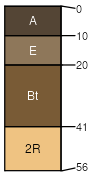
hills / Shoulder hills / Backslope
|
|
Nickin (3%)
Loamy Upland
Typic Argiudolls
Well drained
Hydric: No
PAWS: 21 cm |
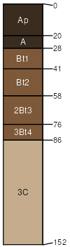
hills / Shoulder hills / Backslope
|
|
Dakota (2%)
Loamy Upland with Carbonates
Typic Argiudolls
Well drained
Hydric: No
PAWS: 18 cm |
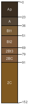
outwash plains / Shoulder outwash plains / Backslope stream terraces
|
|