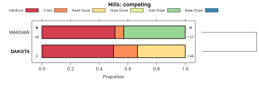
| Dakota loam, 0 to 2 percent slopes | 379A | 3771 | 1019393 | 136rn | il007 | 2006 | 1:12000 |
Dakota loam, 2 to 5 percent slopes | 379B | 435 | 615661 | nnn1 | il057 | 1997 | 1:12000 |
Dakota loam, 0 to 2 percent slopes | 379A | 203 | 615660 | nnn0 | il057 | 1997 | 1:12000 |
Dakota loam, 2 to 5 percent slopes | 379B | 146 | 175190 | 5w99 | il067 | 1993 | 1:15840 |
Dakota loam, 2 to 5 percent slopes, rarely flooded | 7379B | 128 | 2604125 | 2r797 | il067 | 1993 | 1:15840 |
Dakota sandy loam, 2 to 5 percent slopes, eroded | 379B2 | 5161 | 937030 | 10g1s | il103 | 2004 | 1:12000 |
Dakota loam, 0 to 2 percent slopes | 379A | 8146 | 182694 | 643c | il111 | 1997 | 1:12000 |
Dakota loam, 2 to 4 percent slopes | 379B | 750 | 182695 | 643d | il111 | 1997 | 1:12000 |
Dakota loam, 0 to 2 percent slopes | 379A | 5637 | 182180 | 63ks | il123 | 1997 | 1:15840 |
Dakota loam, 2 to 5 percent slopes | 379B | 2745 | 182181 | 63kt | il123 | 1997 | 1:15840 |
Dakota fine sandy loam, 0 to 2 percent slopes | 379A | 10791 | 177796 | 5z0c | il125 | 1989 | 1:15840 |
Dakota fine sandy loam, 2 to 5 percent slopes | 379B | 1416 | 177797 | 5z0d | il125 | 1989 | 1:15840 |
Dakota loam, 0 to 2 percent slopes | 379A | 211 | 1406382 | 1j6g5 | il129 | 2005 | 1:12000 |
Dakota loam, 0 to 2 percent slopes | 379A | 967 | 172805 | 5stc | il155 | 1987 | 1:15840 |
Dakota loam, 2 to 5 percent slopes, eroded | 379B2 | 519 | 172807 | 5stf | il155 | 1987 | 1:15840 |
Dakota fine sandy loam, 0 to 2 percent slopes, rarely flooded | 7379A | 56 | 2650846 | 2r21s | il155 | 1987 | 1:15840 |
Dakota silt loam, 5 to 10 percent slopes, eroded | 379C2 | 531 | 179099 | 60cd | il175 | 1992 | 1:15840 |
Dakota fine sandy loam, 0 to 2 percent slopes | 379A | 5042 | 179406 | 60p9 | il179 | 1991 | 1:15840 |
Dakota fine sandy loam, 2 to 5 percent slopes | 379B | 1834 | 179407 | 60pb | il179 | 1991 | 1:15840 |
Dakota fine sandy loam, 2 to 5 percent slopes, rarely flooded | 7379B | 113 | 2509793 | 2qgxr | il179 | 1991 | 1:15840 |
Dakota fine sandy loam, 0 to 2 percent slopes, rarely flooded | 7379A | 92 | 2509792 | 2qgxq | il179 | 1991 | 1:15840 |
Dakota loam, 0 to 2 percent slopes | 379A | 340 | 174065 | 5v40 | il201 | 1997 | 1:12000 |
Dakota loam, 0 to 2 percent slopes | 379A | 354 | 869218 | y5h9 | il203 | 2008 | 1:12000 |
Dakota and Rasset sandy loams, 0 to 2 percent slopes | DA | 329 | 396410 | f9hf | mn019 | 1987 | 1:12000 |
Dakota and Rasset sandy loams, 2 to 6 percent slopes | DB | 290 | 396411 | f9hg | mn019 | 1987 | 1:12000 |
Dakota silt loam, 0 to 3 percent slopes | M525A | 2310 | 1386866 | 1hk4m | mn039 | 2005 | 1:12000 |
Dakota loam, 0 to 1 percent slopes | De | 1083 | 2216716 | 2ddnz | mn045 | 2008 | 1:12000 |
Dakota fine sandy loam, 2 to 6 percent slopes | Db | 581 | 2216715 | 2ddny | mn045 | 2008 | 1:12000 |
Dakota loam, 2 to 6 percent slopes | Df | 483 | 2216717 | 2ddp0 | mn045 | 2008 | 1:12000 |
Dakota fine sandy loam, 0 to 1 percent slopes | Da | 281 | 2216714 | 2ddnx | mn045 | 2008 | 1:12000 |
Dakota fine sandy loam, 12 to 17 percent slopes, moderately eroded | Dd | 63 | 2216712 | 2ddnv | mn045 | 2008 | 1:12000 |
Dakota loam, 2 to 6 percent slopes | 5B | 2690 | 397880 | fc0v | mn047 | 1977 | 1:15840 |
Dakota loam, 0 to 2 percent slopes | 5 | 1603 | 397872 | fc0l | mn047 | 1977 | 1:15840 |
Dakota loam, 6 to 14 percent slopes | 5C | 728 | 397881 | fc0w | mn047 | 1977 | 1:15840 |
Dakota silt loam, 0 to 3 percent slopes | N579A | 6264 | 1690487 | 1tr2v | mn049 | 2007 | 1:12000 |
Dakota silt loam, 0 to 3 percent slopes | M525A | 1116 | 1670742 | 1t2jx | mn049 | 2007 | 1:12000 |
Dakota loam, 0 to 2 percent slopes | DaA | 1235 | 427949 | gc9t | mn139 | 1988 | 1:20000 |
Dakota loam, 2 to 6 percent slopes | DaB | 142 | 427950 | gc9v | mn139 | 1988 | 1:20000 |
Dakota loam, 2 to 6 percent slopes, moderately eroded | DaB2 | 130 | 427951 | gc9w | mn139 | 1988 | 1:20000 |
Dakota loam, 6 to 12 percent slopes, moderately eroded | DaC2 | 31 | 427952 | gc9x | mn139 | 1988 | 1:20000 |
Dakota loam, 1 to 6 percent slopes | 5B | 775 | 431537 | gh1k | mn143 | 1991 | 1:20000 |
Dakota loam, 2 to 6 percent slopes | 5B | 1457 | 428170 | gcjy | mn145 | 1980 | 1:15840 |
Dakota loam, 0 to 2 percent slopes | 5A | 1385 | 428169 | gcjx | mn145 | 1980 | 1:15840 |
Dakota loam, 2 to 6 percent slopes | DkB | 815 | 428226 | gclr | mn147 | 1967 | 1:20000 |
Dakota sandy loam, 2 to 6 percent slopes | DaB | 788 | 428223 | gcln | mn147 | 1967 | 1:20000 |
Dakota loam, 0 to 2 percent slopes | DkA | 594 | 428225 | gclq | mn147 | 1967 | 1:20000 |
Dakota sandy loam, 6 to 14 percent slopes | DaC | 530 | 428224 | gclp | mn147 | 1967 | 1:20000 |
Dakota sandy loam, 0 to 2 percent slopes | DaA | 418 | 428222 | gclm | mn147 | 1967 | 1:20000 |
Dakota silt loam, 0 to 3 percent slopes | 403A | 542 | 2561692 | 1lmx9 | wi011 | 1960 | 1:12000 |
Dakota silt loam, 2 to 6 percent slopes | 403B | 121 | 2639461 | 2rhz2 | wi011 | 1960 | 1:12000 |
Dakota silt loam, 0 to 3 percent slopes | 403A | 769 | 2504026 | 1lmx9 | wi023 | 1960 | 1:12000 |
Dakota silt loam, 0 to 3 percent slopes | 403A | 2753 | 2504027 | 1lmx9 | wi033 | 2003 | 1:12000 |
Dakota silt loam, 0 to 3 percent slopes | 403A | 326 | 3099678 | 1lmx9 | wi035 | 1974 | 1:12000 |
Dakota fine sandy loam, 0 to 2 percent slopes | 402A | 519 | 424151 | g7c9 | wi043 | 1959 | 1:20000 |
Dakota fine sandy loam, 2 to 6 percent slopes | 402B | 167 | 424152 | g7cb | wi043 | 1959 | 1:20000 |
Dakota fine sandy loam, 6 to 10 percent slopes, moderately eroded | 402C2 | 44 | 424153 | g7cc | wi043 | 1959 | 1:20000 |
Dakota loam, 0 to 2 percent slopes | 404A | 1186 | 425214 | g8gl | wi045 | 1969 | 1:12000 |
Dakota loam, 2 to 6 percent slopes, moderately eroded | 404B2 | 435 | 425215 | g8gm | wi045 | 1969 | 1:12000 |
Dakota silt loam, 0 to 3 percent slopes | 403A | 676 | 2774813 | 1lmx9 | wi049 | 1960 | 1:20000 |
Dakota silt loam, 0 to 3 percent slopes | 403A | 444 | 2504028 | 1lmx9 | wi063 | 2001 | 1:12000 |
Dakota loam, mottled subsoil variant, 0 to 3 percent slopes | 488A | 137 | 424755 | g7zs | wi065 | 1964 | 1:15840 |
Dakota loam, 2 to 6 percent slopes | 404B | 133 | 424754 | g7zr | wi065 | 1964 | 1:15840 |
Dakota loam, 0 to 2 percent slopes | 404A | 38 | 424753 | g7zq | wi065 | 1964 | 1:15840 |
Dakota silt loam, 0 to 3 percent slopes | 403A | 107 | 2504029 | 1lmx9 | wi091 | 1998 | 1:12000 |
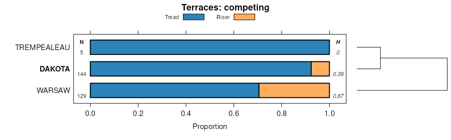
Dakota loam, strath terrace, 0 to 3 percent slopes | 3401A | 8177 | 1697385 | 1tz8c | wi093 | 2006 | 1:12000 |
Dakota loam, till plain, 0 to 3 percent slopes | 404A | 855 | 1698631 | 1v0kk | wi093 | 2006 | 1:12000 |
Dakota silt loam, 0 to 3 percent slopes | 403A | 731 | 1690944 | 1trkl | wi093 | 2006 | 1:12000 |
Dakota loam, limestone substratum, 0 to 3 percent slopes | 3170A | 1357 | 421183 | g48k | wi095 | 1978 | 1:15840 |
Dakota loam, 0 to 2 percent slopes | 3401A | 974 | 421181 | g48h | wi095 | 1978 | 1:15840 |
Dakota variant silt loam, 0 to 3 percent slopes | 3300A | 705 | 421184 | g48l | wi095 | 1978 | 1:15840 |
Dakota loam, 2 to 6 percent slopes | 3401B | 699 | 421182 | g48j | wi095 | 1978 | 1:15840 |
Dakota silt loam, 0 to 3 percent slopes | 403A | 217 | 2504030 | 1lmx9 | wi103 | 2002 | 1:12000 |
Dakota loam, 2 to 6 percent slopes | 404B | 1998 | 422129 | g582 | wi109 | 1975 | 1:15840 |
Dakota-Pillot complex, 6 to 12 percent slopes, eroded | 1404C2 | 860 | 422130 | g583 | wi109 | 1975 | 1:15840 |
Dakota loam, 0 to 2 percent slopes | 404A | 808 | 422128 | g581 | wi109 | 1975 | 1:15840 |
Dakota loam, 0 to 2 percent slopes | 404A | 4124 | 423137 | g69l | wi111 | 1977 | 1:15840 |
Dakota loam, 2 to 6 percent slopes | 404B | 2115 | 423138 | g69m | wi111 | 1977 | 1:15840 |
Dakota silt loam, 2 to 6 percent slopes | 403B | 489 | 2683483 | 2rhz2 | wi121 | 1969 | 1:12000 |
Dakota silt loam, 0 to 3 percent slopes | 403A | 198 | 2683472 | 1lmx9 | wi121 | 1969 | 1:12000 |
Dakota silt loam, 0 to 3 percent slopes | 403A | 10 | 2504031 | 1lmx9 | wi123 | 1965 | 1:12000 |