Coland-Spillville complex, channeled, 2 to 5 percent slopes
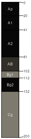
Coland
(65%)
Wet Floodplains
Cumulic Endoaquolls
Poorly drained
Hydric: Yes
PAWS: 29 cm
drainageways / Toeslope
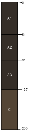
Spillville
(25%)
Footslope/Drainageway Prairies
Cumulic Hapludolls
Moderately well drained
Hydric: No
PAWS: 32 cm
drainageways / Toeslope
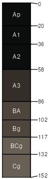
Colo
(5%)
Wet Floodplains
Cumulic Endoaquolls
Poorly drained
Hydric: Yes
PAWS: 30 cm
drainageways / Footslope
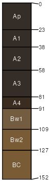
Terril
(5%)
Footslope/Drainageway Forests
Cumulic Hapludolls
Moderately well drained
Hydric: No
PAWS: 28 cm
drainageways / Footslope
SSA
Scale
Published
Export
ia161
1:16,000
1975
2025-09-09