| Terril loam, 5 to 9 percent slopes | 27C | 1169 | 2550253 | fjd3 | ia015 | 1977 | 1:15840 |
Terril loam, 4 to 9 percent slopes | 27C | 568 | 403288 | fjn9 | ia021 | 1973 | 1:15840 |
Terril loam, 2 to 5 percent slopes | 27B | 1568 | 403386 | 2y8r1 | ia023 | 1978 | 1:15840 |
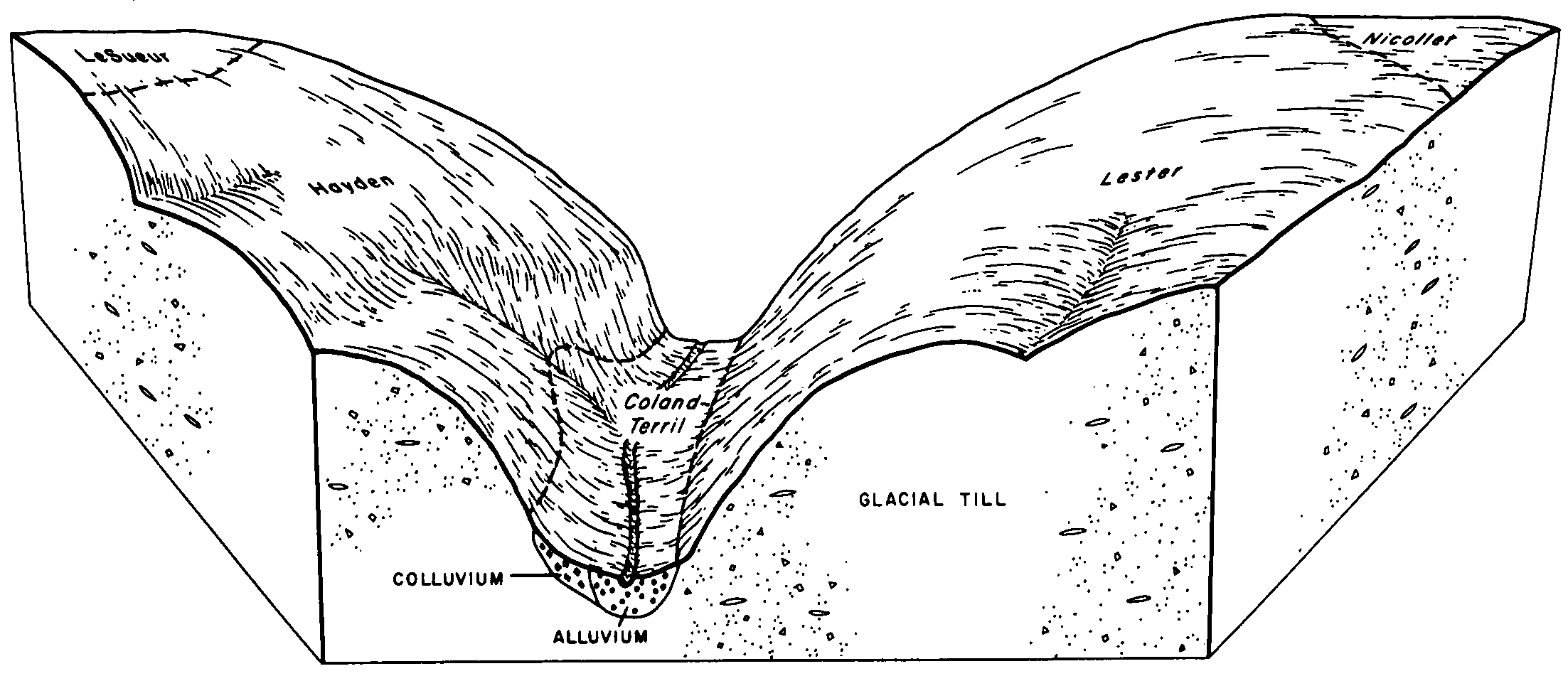
Coland, occasionally flooded-Terril complex, 1 to 4 percent slopes | 201B | 740 | 403375 | 2y8r6 | ia023 | 1978 | 1:15840 |
Terril loam, 2 to 6 percent slopes | 27B | 442 | 403470 | 2tsjq | ia025 | 1979 | 1:15840 |
Terril loam, 2 to 6 percent slopes | 27B | 665 | 403528 | 2tsjq | ia027 | 1979 | 1:15840 |
Terril loam, 5 to 9 percent slopes | 27C | 384 | 403529 | fjx2 | ia027 | 1979 | 1:15840 |
Terril loam, 2 to 6 percent slopes | 27B | 1465 | 403822 | 2tsjq | ia033 | 1978 | 1:15840 |
Coland-Terril complex, 1 to 4 percent slopes | 201B | 679 | 403802 | fk5w | ia033 | 1978 | 1:15840 |
Terril-Coland, occasionally flooded complex, 2 to 9 percent slopes | 438C | 2098 | 403907 | 2y6bc | ia035 | 1987 | 1:15840 |
Terril loam, 5 to 9 percent slopes | 27C | 1732 | 403917 | fk9l | ia035 | 1987 | 1:15840 |
Terril loam, 2 to 5 percent slopes | 27B | 1167 | 403916 | fk9k | ia035 | 1987 | 1:15840 |
Terril loam, 0 to 2 percent slopes | 27 | 516 | 403915 | fk9j | ia035 | 1987 | 1:15840 |
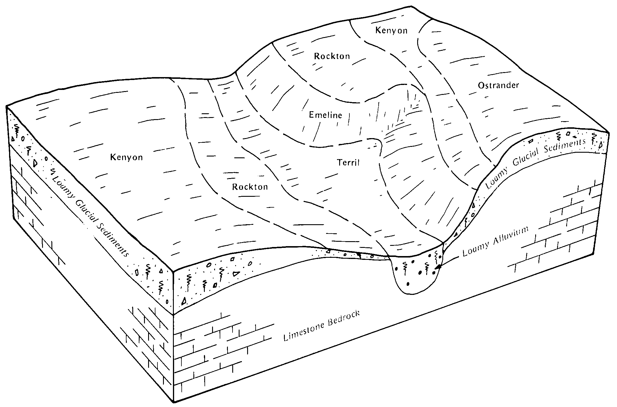
Coland-Terril complex, 2 to 5 percent slopes | 201B | 2885 | 399302 | fdhq | ia041 | 2002 | 1:12000 |
Terril loam, 2 to 6 percent slopes | 27B | 1742 | 399324 | 2tsjq | ia041 | 2002 | 1:12000 |
Terril loam, 5 to 9 percent slopes | 27C | 1026 | 399325 | fdjg | ia041 | 2002 | 1:12000 |
Terril loam, 9 to 14 percent slopes | 27D | 277 | 399326 | fdjh | ia041 | 2002 | 1:12000 |
Coland-Terril complex, 2 to 5 percent slopes | 201B | 5161 | 404582 | fl01 | ia049 | 1980 | 1:15840 |
Terril loam, 2 to 6 percent slopes | 27B | 1549 | 404588 | 2tsjq | ia049 | 1980 | 1:15840 |
Terril loam, 5 to 9 percent slopes | 27C | 761 | 404589 | fl08 | ia049 | 1980 | 1:15840 |
Delft-Terril complex, 1 to 5 percent slopes | 1707B | 8856 | 2481229 | 2p8xn | ia059 | 2011 | 1:12000 |
Terril loam, 2 to 6 percent slopes | 27B | 2020 | 1869017 | 2tsjq | ia059 | 2011 | 1:12000 |
Terril loam, 2 to 5 percent slopes | 27B | 1557 | 405412 | 2y8r1 | ia061 | 1983 | 1:15840 |
Delft-Terril complex, 2 to 5 percent slopes | 1707B | 660 | 405516 | flz5 | ia063 | 1989 | 1:15840 |
Terril loam, 0 to 2 percent slopes | 27 | 357 | 405543 | fm01 | ia063 | 1989 | 1:15840 |
Terril loam, 2 to 6 percent slopes | 27B | 278 | 405544 | 2tsjq | ia063 | 1989 | 1:15840 |
Terril loam, 5 to 9 percent slopes | 27C | 232 | 405545 | fm03 | ia063 | 1989 | 1:15840 |
Terril loam, 2 to 5 percent slopes | 27B | 1193 | 405749 | 2y8r1 | ia065 | 1975 | 1:15840 |
Terril loam, 2 to 5 percent slopes | 27B | 3575 | 405894 | 2y8r1 | ia067 | 1989 | 1:15840 |
Terril loam, 0 to 2 percent slopes | 27 | 1428 | 405893 | 2y8r0 | ia067 | 1989 | 1:15840 |
Coland, occasionally flooded-Terril complex, 1 to 4 percent slopes | 201B | 214 | 405872 | 2y8r6 | ia067 | 1989 | 1:15840 |
Coland-Terril complex, 1 to 5 percent slopes | 201B | 2709 | 404882 | fl9q | ia069 | 1977 | 1:15840 |
Terril loam, 2 to 6 percent slopes | 27B | 2270 | 404895 | 2tsjq | ia069 | 1977 | 1:15840 |
Terril loam, 3 to 8 percent slopes | 27C | 227 | 406131 | fmm0 | ia071 | 1968 | 1:20000 |
Terril loam, 2 to 6 percent slopes | 27B | 642 | 406215 | 2tsjq | ia073 | 1983 | 1:15840 |
Terril loam, 5 to 9 percent slopes | 27C | 553 | 406216 | fmpr | ia073 | 1983 | 1:15840 |
Terril loam, 2 to 6 percent slopes | 27B | 1261 | 406475 | 2tsjq | ia079 | 1984 | 1:15840 |
Coland-Terril complex, 1 to 5 percent slopes | 201B | 1198 | 406468 | fmyw | ia079 | 1984 | 1:15840 |
Terril loam, 5 to 9 percent slopes | 27C | 94 | 406476 | fmz4 | ia079 | 1984 | 1:15840 |
Coland-Terril complex, 2 to 5 percent slopes | 201B | 6993 | 406637 | fn4b | ia083 | 1982 | 1:15840 |
Terril loam, 2 to 6 percent slopes | 27B | 3177 | 406650 | 2tsjq | ia083 | 1982 | 1:15840 |
Terril loam, 2 to 5 percent slopes | 27B | 2213 | 406934 | 2y8r1 | ia089 | 1969 | 1:15840 |
Terril loam, 0 to 2 percent slopes | 27A | 1327 | 406933 | 2y8r0 | ia089 | 1969 | 1:15840 |
Terril loam, 2 to 6 percent slopes | 27B | 1073 | 447443 | 2tsjq | ia091 | 1998 | 1:12000 |
Coland-Terril complex, 2 to 5 percent slopes | 201B | 766 | 447634 | h0st | ia091 | 1998 | 1:12000 |
Terril loam, 5 to 9 percent slopes | 27C | 259 | 407118 | fnmv | ia093 | 1989 | 1:15840 |
Terril loam, 2 to 5 percent slopes | 27B | 231 | 407117 | fnmt | ia093 | 1989 | 1:15840 |
Terril loam, 2 to 5 percent slopes | 27B | 1001 | 407485 | fp0p | ia097 | 1988 | 1:15840 |
Terril loam, 2 to 6 percent slopes | 27B | 1120 | 407648 | 2tsjq | ia099 | 1975 | 1:15840 |
Terril loam, 2 to 5 percent slopes | 27B | 2141 | 408130 | 2y8r1 | ia105 | 1988 | 1:15840 |
Terril loam, 5 to 9 percent slopes | 27C | 375 | 408131 | 2y8r2 | ia105 | 1988 | 1:15840 |
Terril loam, 2 to 5 percent slopes | 27B | 1857 | 409086 | fqpb | ia119 | 1973 | 1:15840 |
Terril loam, 5 to 9 percent slopes | 27C | 815 | 409087 | fqpc | ia119 | 1973 | 1:15840 |
Terril loam, 9 to 14 percent slopes | 27D | 233 | 409088 | fqpd | ia119 | 1973 | 1:15840 |
Coland-Terril complex, 2 to 5 percent slopes | 201B | 1913 | 409446 | fr1y | ia127 | 1978 | 1:15840 |
Terril loam, sandy substratum, 5 to 9 percent slopes | 323C | 377 | 409465 | fr2k | ia127 | 1978 | 1:15840 |
Terril loam, 2 to 5 percent slopes | 27B | 623 | 409656 | 2y8r1 | ia131 | 1971 | 1:15840 |
Terril loam, 0 to 2 percent slopes | 27 | 514 | 409655 | 2y8r0 | ia131 | 1971 | 1:15840 |
Terril loam, 5 to 14 percent slopes | 27C | 911 | 410065 | frpx | ia141 | 1977 | 1:15840 |
Terril loam, 2 to 5 percent slopes | 27B | 777 | 410064 | frpw | ia141 | 1977 | 1:15840 |
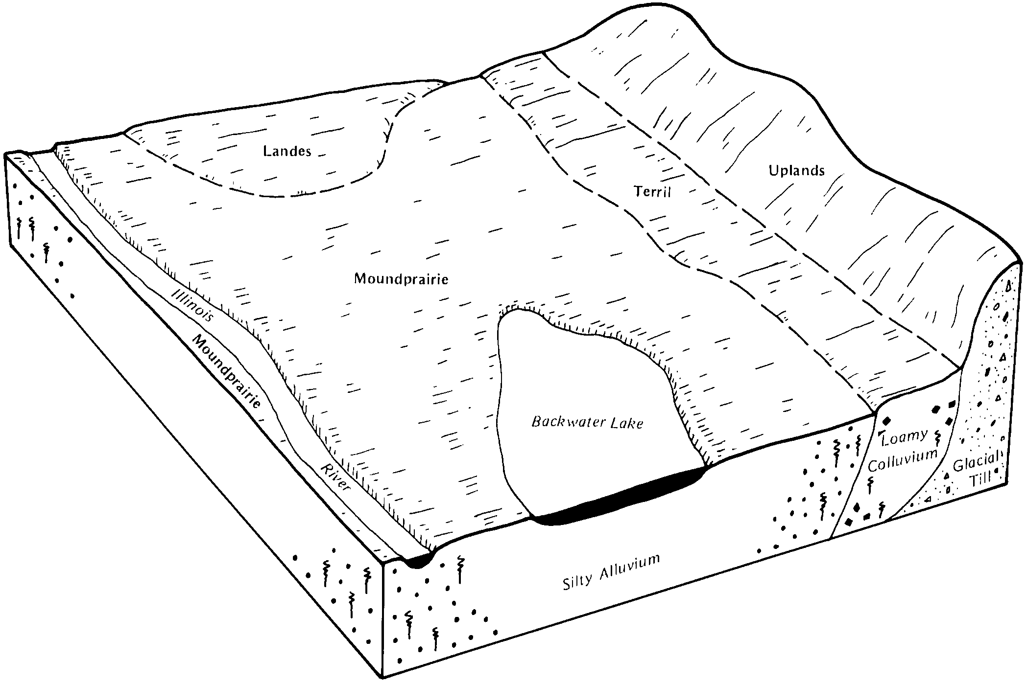
Terril-Colo, frequently flooded complex, 2 to 10 percent slopes | 1659C | 417 | 410058 | 2y6bd | ia141 | 1977 | 1:15840 |
Terril loam, 2 to 6 percent slopes | 27B | 448 | 2506585 | 2tsjq | ia143 | 1985 | 1:15840 |
Coland-Terril complex, 2 to 5 percent slopes | 201B | 332 | 410116 | frrk | ia143 | 1985 | 1:15840 |
Delft-Terril complex, 1 to 5 percent slopes | 1707B | 79 | 2506567 | 2q4md | ia143 | 1985 | 1:15840 |
Terril loam, 2 to 6 percent slopes | 27B | 253 | 410385 | 2tsjq | ia151 | 1982 | 1:15840 |
Coland, occasionally flooded-Terril complex, 2 to 5 percent slopes | 201B | 3514 | 412867 | fvm9 | ia153 | 1993 | 1:12000 |
Terril loam, 2 to 6 percent slopes | 27B | 1742 | 412883 | 2tsjq | ia153 | 1993 | 1:12000 |
Coland, occasionally flooded-Terril-Urban land complex, 2 to 5 percent slopes | 4201B | 441 | 412929 | fvp9 | ia153 | 1993 | 1:12000 |
Terril-Urban land complex, 2 to 5 percent slopes | 4027B | 333 | 412898 | fvn9 | ia153 | 1993 | 1:12000 |
Terril loam, 2 to 6 percent slopes | 27C | 528 | 410787 | 2tsjq | ia161 | 1975 | 1:15840 |
Terril loam, sandy substratum, 2 to 5 percent slopes | 323B | 271 | 410797 | fsgj | ia161 | 1975 | 1:15840 |
Terril loam, 2 to 5 percent slopes | 27B | 1844 | 411203 | fswm | ia167 | 1987 | 1:15840 |
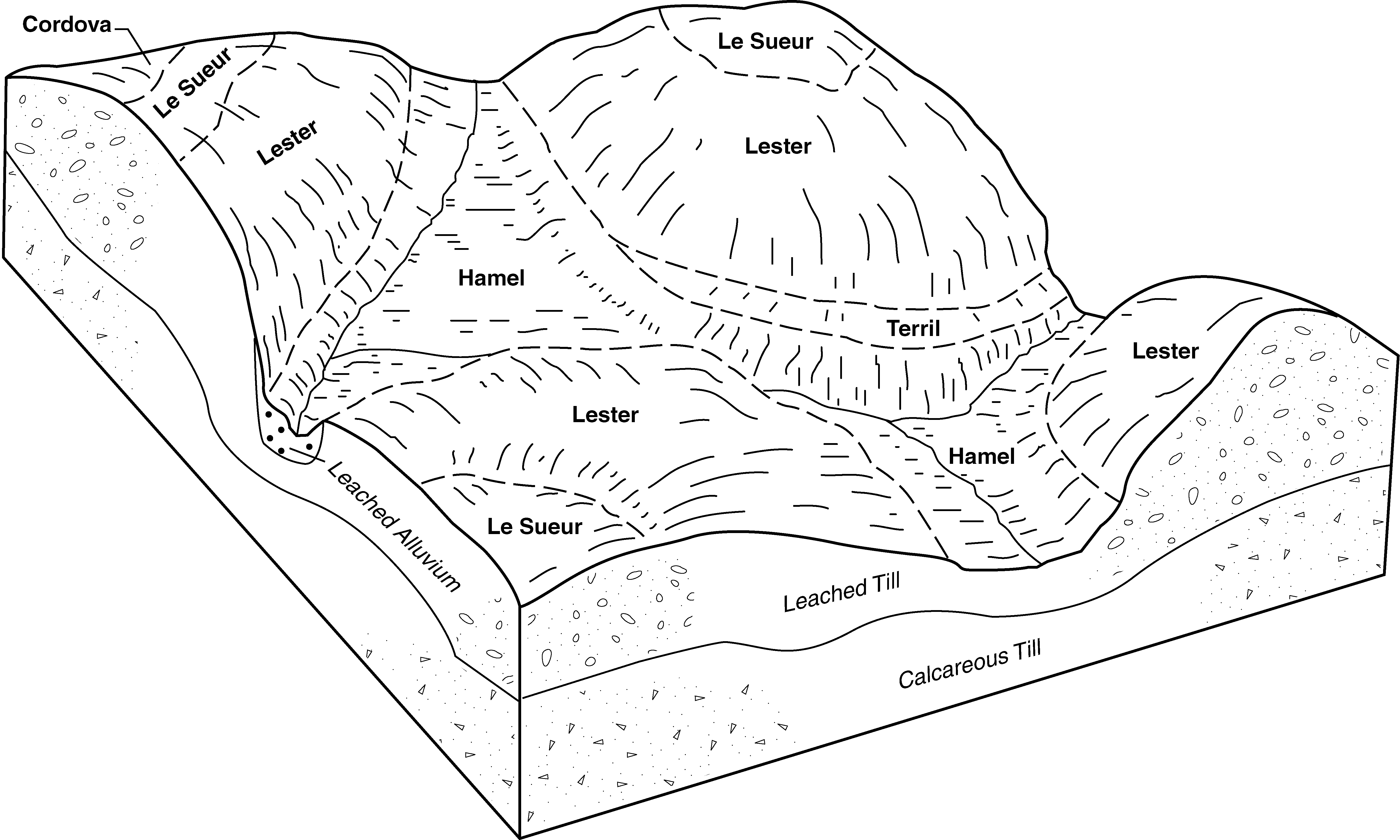
Coland-Terril complex, 1 to 5 percent slopes | 201B | 4345 | 411293 | fszj | ia169 | 1981 | 1:15840 |
Terril loam, 2 to 6 percent slopes | 27B | 2418 | 411307 | 2tsjq | ia169 | 1981 | 1:15840 |
Terril loam, 5 to 9 percent slopes | 27C | 422 | 411308 | ft00 | ia169 | 1981 | 1:15840 |
Terril loam, 2 to 6 percent slopes | 27B | 1624 | 1428506 | 2tsjq | ia187 | 2006 | 1:12000 |
Coland-Terril complex, 1 to 5 percent slopes | 201B | 875 | 797929 | vs9n | ia187 | 2006 | 1:12000 |
Terril loam, 2 to 5 percent slopes | 27B | 446 | 451039 | 2y8r1 | ia191 | 2005 | 1:12000 |
Terril loam, 2 to 6 percent slopes | 27B | 759 | 2398663 | 2tsjq | ia195 | 2012 | 1:12000 |
Terril loam, 2 to 6 percent slopes | 27B | 2801 | 412676 | 2tsjq | ia197 | 1988 | 1:15840 |
Coland-Terril complex, 1 to 5 percent slopes | 201B | 1601 | 412669 | fvdx | ia197 | 1988 | 1:15840 |
Terril loam, 2 to 5 percent slopes | 587B | 786 | 199199 | 6p8s | il117 | 1999 | 1:12000 |
Shoals and Terril loams, 1 to 4 percent slopes, rarely flooded | 7788B | 1325 | 1721503 | 1vscc | il135 | 2007 | 1:12000 |
Terril loam, 2 to 5 percent slopes, rarely flooded | 7587B | 478 | 2650848 | 2r21v | il155 | 1987 | 1:15840 |
Terril loam, 2 to 5 percent slopes | 587B | 82 | 172849 | 5svs | il155 | 1987 | 1:15840 |
Terril loam, 2 to 6 percent slopes | 94B | 1964 | 396227 | 2tsjq | mn013 | 1975 | 1:12000 |
Terril loam, 6 to 15 percent slopes | 94C | 579 | 396228 | f99k | mn013 | 1975 | 1:12000 |
Terril loam, 0 to 2 percent slopes | 94 | 481 | 396223 | f99d | mn013 | 1975 | 1:12000 |
Terril-Urban land complex, 6 to 15 percent slopes | 856C | 159 | 396209 | f98y | mn013 | 1975 | 1:12000 |
Terril-Urban land complex, 2 to 6 percent slopes | 856B | 138 | 396208 | f98x | mn013 | 1975 | 1:12000 |
Clarion-Terril loams, 25 to 50 percent slopes | 1919F | 3385 | 396268 | f9bv | mn015 | 1984 | 1:20000 |
Terril loam, 2 to 6 percent slopes | 94B | 1884 | 396320 | 2tsjq | mn015 | 1984 | 1:20000 |
Terril loam, 6 to 12 percent slopes | 94C | 324 | 396321 | f9dk | mn015 | 1984 | 1:20000 |
Terril loam, 2 to 6 percent slopes | TB | 3461 | 396469 | 2tsjq | mn019 | 1987 | 1:12000 |
Terril loam, 6 to 12 percent slopes | TC | 192 | 396470 | f9kc | mn019 | 1987 | 1:12000 |
Terril loam, 2 to 6 percent slopes | 94B | 620 | 396533 | 2tsjq | mn023 | 1980 | 1:15840 |
Terril loam, 2 to 6 percent slopes | L129B | 1495 | 2421638 | 2tsjq | mn033 | 2008 | 1:12000 |
Terril loam, firm till substratum, 2 to 6 percent slopes | L242B | 37 | 2400512 | 2lkxw | mn033 | 2008 | 1:12000 |
Terril loam, 4 to 12 percent slopes | 94C | 1126 | 396908 | fb0h | mn037 | 1980 | 1:15840 |
Terril loam, 2 to 6 percent slopes | 94B | 1280 | 397131 | 2tsjq | mn043 | 1989 | 1:20000 |
Swanlake-Terril complex, 18 to 40 percent slopes | 1852F | 892 | 397089 | fb6b | mn043 | 1989 | 1:20000 |
Terril loam, 2 to 6 percent slopes | 94B | 2468 | 397900 | 2tsjq | mn047 | 1977 | 1:15840 |
Terril loam, sandy substratum | 1812 | 891 | 398229 | fcd3 | mn055 | 1981 | 1:15840 |
Terril-Swanlake loams, 25 to 40 percent slopes | 1852F | 2225 | 398495 | fcnp | mn063 | 1984 | 1:20000 |
Terril loam, 2 to 6 percent slopes | 94B | 1371 | 398525 | 2tsjq | mn063 | 1984 | 1:20000 |
Terril loam | 94 | 206 | 398734 | fcxd | mn067 | 1983 | 1:20000 |
Terril loam, 2 to 6 percent slopes | 94B | 1923 | 398980 | 2tsjq | mn079 | 1986 | 1:20000 |
Terril loam, 2 to 6 percent slopes | L129B | 2 | 1544677 | 2tsjq | mn081 | 2007 | 1:12000 |
Terril loam, firm till substratum, 2 to 6 percent slopes | L242B | 49 | 2400514 | 2lkxy | mn083 | 2008 | 1:12000 |
Terril loam, 2 to 6 percent slopes | 94B | 500 | 399187 | 2tsjq | mn085 | 1993 | 1:20000 |
Terril loam, 2 to 6 percent slopes | 94B | 1906 | 400071 | 2tsjq | mn091 | 1985 | 1:20000 |
Terril-Swanlake loams, 18 to 40 percent slopes | 1852F | 221 | 400033 | ff89 | mn091 | 1985 | 1:20000 |
Terril loam, 2 to 6 percent slopes | 94B | 2232 | 1859414 | 2tsjq | mn101 | 2008 | 1:12000 |
Terril loam, firm till substratum, 2 to 6 percent slopes | L242B | 92 | 2386603 | 2l3g6 | mn101 | 2008 | 1:12000 |
Terril loam, 2 to 6 percent slopes | 94B | 2595 | 400624 | 2tsjq | mn103 | 1990 | 1:20000 |
Terril loam, 6 to 12 percent slopes | 94C | 1101 | 400625 | ffwd | mn103 | 1990 | 1:20000 |
Terril loam, 2 to 6 percent slopes | L129B | 553 | 780788 | 2tsjq | mn105 | 2004 | 1:12000 |
Terril loam, sandy substratum, 1 to 6 percent slopes | 1812B | 3818 | 400720 | ffzg | mn109 | 1977 | 1:15840 |
Terril-Swanlake loams, 25 to 70 percent slopes | 1852F | 2856 | 2374065 | 2kpdr | mn127 | 2008 | 1:12000 |
Terril loam, 2 to 6 percent slopes | 94B | 1841 | 2374014 | 2tsjq | mn127 | 2008 | 1:12000 |
Terril loam, 6 to 12 percent slopes | 94C | 586 | 2374015 | 2kpc4 | mn127 | 2008 | 1:12000 |
Terril loam, firm till substratum, 2 to 6 percent slopes | L242B | 62 | 2399154 | 2ljj2 | mn127 | 2008 | 1:12000 |
Swanlake-Terril complex, 18 to 50 percent slopes | 1242F | 5283 | 436011 | gmpw | mn129 | 1995 | 1:20000 |
Terril loam, 2 to 6 percent slopes | 1388B | 1747 | 436037 | 2tsjq | mn129 | 1995 | 1:20000 |
Ves-Terril complex, 6 to 15 percent slopes, eroded | 770C2 | 1161 | 436116 | gmt8 | mn129 | 1995 | 1:20000 |
Terril loam, 6 to 12 percent slopes | 94C | 118 | 436137 | gmty | mn129 | 1995 | 1:20000 |
Terril loam, 2 to 6 percent slopes | 1388B | 2291 | 429564 | 2tsjq | mn131 | 1996 | 1:12000 |
Terril loam, 2 to 6 percent slopes | TcB | 2735 | 428049 | 2tsjq | mn139 | 1988 | 1:20000 |
Terril loam, 0 to 2 percent slopes | TcA | 642 | 428048 | gcf0 | mn139 | 1988 | 1:20000 |
Terril loam, 6 to 12 percent slopes | TcC | 327 | 428050 | gcf2 | mn139 | 1988 | 1:20000 |
Terril loam, 6 to 12 percent slopes | TbC | 156 | 428045 | gcdx | mn139 | 1988 | 1:20000 |
Terril loam, 12 to 18 percent slopes | TbD | 136 | 428046 | gcdy | mn139 | 1988 | 1:20000 |
Terril loam, 12 to 18 percent slopes | TcD | 134 | 428051 | gcf3 | mn139 | 1988 | 1:20000 |
Terril loam, 18 to 25 percent slopes | TbE | 19 | 428047 | gcdz | mn139 | 1988 | 1:20000 |
Terril loam, 18 to 25 percent slopes | TcE | 6 | 428052 | gcf4 | mn139 | 1988 | 1:20000 |
Terril loam, 2 to 6 percent slopes | 94B | 1139 | 431551 | 2tsjq | mn143 | 1991 | 1:20000 |
Spillville, ocassionally flooded | Te | 445 | 428297 | gcp1 | mn147 | 1967 | 1:20000 |
Terril loam, 2 to 6 percent slopes | L129B | 2591 | 579841 | 2tsjq | mn161 | 2001 | 1:12000 |
Terril loam, 2 to 6 percent slopes | 1388B | 1125 | 435067 | 2tsjq | mn171 | 1998 | 1:12000 |
Terril-Swanlake loams, 18 to 70 percent slopes | 1852F | 1764 | 1653570 | 1shnz | mn173 | 1979 | 1:20000 |
Terril loam, 2 to 6 percent slopes | 94B | 1755 | 1653639 | 2tsjq | mn173 | 1979 | 1:20000 |
Terril loam, 6 to 12 percent slopes | 94C | 431 | 1653640 | 1shr7 | mn173 | 1979 | 1:20000 |