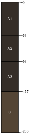
Spillville loam, channeled, 0 to 2 percent slopes
Spillville
(92%)
Loamy Floodplain Forest
Cumulic Hapludolls
Moderately well drained
Hydric: Yes
PAWS: 29 cm
flood plains / Toeslope
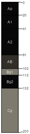
Coland
(5%)
Wet Floodplain Sedge Meadow
Floodplain Swamp Forest
Cumulic Endoaquolls
Poorly drained
Hydric: Yes
PAWS: 31 cm
flood plains / Toeslope
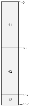
Aquents
(3%)
Sandy Floodplain Forest
Cumulic Endoaquolls
Poorly drained
Hydric: Yes
PAWS: 31 cm
flood plains / Toeslope
SSA
Scale
Published
Export
ia103
1:16,000
1979
2025-09-08