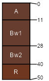
Quinlan (55%)
Shallow Upland
Typic Haplustepts
Well drained
Hydric: No
PAWS: 8 cm |

hillslopes / Shoulder hills / Backslope hills / Shoulder
|
|
Woodward (30%)
Loamy Upland
Typic Haplustepts
Well drained
Hydric: No
PAWS: 15 cm |

hillslopes / Shoulder hills / Shoulder
|
|
Obaro (5%)
Loamy Upland 19-26 PZ
Typic Haplustepts
Well drained
Hydric: No
PAWS: NA |

knolls / Summit ridges / Shoulder
|
|
Cordell (5%)
Red Shale
Lithic Haplustepts
Somewhat excessively drained
Hydric: No
PAWS: NA |

hillslopes / Backslope hills / Backslope
|
|
Carey (5%)
Loamy Upland 19-26 PZ
Typic Argiustolls
Well drained
Hydric: No
PAWS: NA |

hillslopes / Backslope hills / Backslope
|
|