Westola-Quinlan-Hardeman complex, 0 to 12 percent slopes
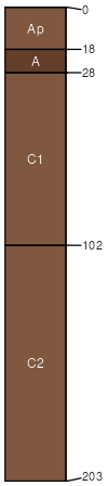
Westola
(48%)
Loamy Bottomland 23-31 PZ
Typic Ustifluvents
Well drained
Hydric: No
PAWS: 30 cm
flood plains
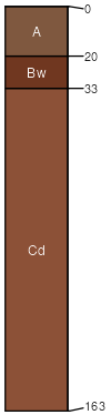
Quinlan
(30%)
Shallow Upland
Typic Haplustepts
Well drained
Hydric: No
PAWS: 7 cm
hillslopes / Backslope
hills
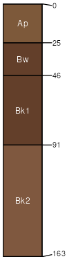
Hardeman
(22%)
Sandy Loam 23-31 PZ
Typic Haplustepts
Well drained
Hydric: No
PAWS: 27 cm
drainageways / Toeslope
SSA
Scale
Published
Export
ok059
1:24,000
1998
2025-08-29