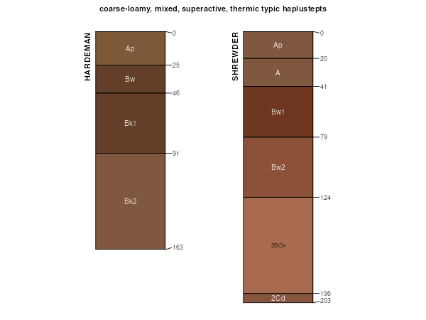
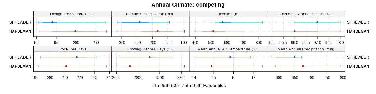
| Hardeman fine sandy loam, 1 to 3 percent slopes, cool | HdmB | 846 | 3101274 | 2tckh | ok007 | 2021 | 1:24000 |
Westola occasionally flooded-Quinlan-Hardeman complex, 0 to 12 percent slopes | WQHE | 394 | 381558 | 2zc1f | ok007 | 2021 | 1:24000 |
Hardeman fine sandy loam, 1 to 3 percent slopes, cool | 30 | 3426 | 381667 | 2tckh | ok009 | 1978 | 1:24000 |
Hardeman fine sandy loam, 3 to 5 percent slopes, cool | 31 | 2564 | 381668 | 2tckj | ok009 | 1978 | 1:24000 |
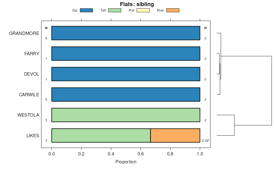
Hardeman-Likes-Fortyone complex, 3 to 20 percent slopes | HLFF | 58 | 623500 | 30yjb | ok009 | 1978 | 1:24000 |
Hardeman fine sandy loam, 5 to 8 percent slopes, cool | HaD | 1318 | 382326 | 2tckk | ok039 | 1973 | 1:24000 |
Hardeman fine sandy loam, 8 to 15 percent slopes, cool | EfE | 28252 | 382367 | 2tckl | ok043 | 1961 | 1:24000 |
Quinlan-Hardeman complex, 5 to 20 percent slopes | Qp | 26425 | 382393 | dtx8 | ok043 | 1961 | 1:24000 |
Hardeman fine sandy loam, 3 to 5 percent slopes, cool | EfC | 15136 | 382365 | 2tckj | ok043 | 1961 | 1:24000 |
Hardeman fine sandy loam, 5 to 8 percent slopes, cool | EfD | 11681 | 382366 | 2tckk | ok043 | 1961 | 1:24000 |
Hardeman fine sandy loam, 1 to 3 percent slopes, cool | EfB | 4970 | 382364 | 2tckh | ok043 | 1961 | 1:24000 |
Hardeman-Likes-Devol complex, 3 to 20 percent slopes | Br | 2153 | 382355 | 2tckm | ok043 | 1961 | 1:24000 |
Hardeman-Likes-Devol complex, 3 to 20 percent slopes | Bn | 35523 | 382422 | 2tckm | ok045 | 1963 | 1:24000 |
Hardeman-Southside-Arnett complex, 3 to 20 percent slopes | HSAF | 11310 | 754292 | 30yjc | ok055 | 2005 | 1:24000 |
Hardeman fine sandy loam, 1 to 3 percent slopes, cool | HdmB | 2948 | 648165 | 2tckh | ok055 | 2005 | 1:24000 |
Hardeman fine sandy loam, 3 to 5 percent slopes, cool | HdmC | 2357 | 648166 | 2tckj | ok055 | 2005 | 1:24000 |
Arnett-Hardeman complex, 3 to 15 percent slopes | ArHF | 669 | 378195 | 2yd7b | ok055 | 2005 | 1:24000 |
Hardeman-Southside-Arnett complex, 3 to 20 percent slopes | HSAF | 4774 | 1385035 | 30yjc | ok057 | 1982 | 1:24000 |
Hardeman fine sandy loam, 1 to 3 percent slopes, cool | 25 | 4379 | 975457 | 2tckh | ok057 | 1982 | 1:24000 |
Hardeman fine sandy loam, 3 to 5 percent slopes, cool | 26 | 2395 | 975458 | 2tckj | ok057 | 1982 | 1:24000 |
Hardeman fine sandy loam, 5 to 8 percent slopes, cool | 27 | 1015 | 975459 | 2tckk | ok057 | 1982 | 1:24000 |
Hardeman fine sandy loam, 8 to 15 percent slopes, cool | 29 | 664 | 975461 | 2tckl | ok057 | 1982 | 1:24000 |
Hardeman fine sandy loam, 5 to 12 percent slopes, moderately eroded | 28 | 540 | 975460 | 30yj6 | ok057 | 1982 | 1:24000 |
Westola-Quinlan-Hardeman complex, 0 to 12 percent slopes | WQHE | 41808 | 383108 | dvnb | ok059 | 1998 | 1:24000 |
Hardeman fine sandy loam, 1 to 3 percent slopes, cool | HdmB | 12479 | 382998 | 2tckh | ok059 | 1998 | 1:24000 |
Hardeman fine sandy loam, 3 to 5 percent slopes, cool | HdmC | 2874 | 382999 | 2tckj | ok059 | 1998 | 1:24000 |
Kingsdown-Hardeman complex, 0 to 12 percent slopes | KiHE | 2782 | 383205 | dvrg | ok059 | 1998 | 1:24000 |
Hardeman-Grandmore complex, 1 to 3 percent slopes | HdGB | 2587 | 383052 | 30yj7 | ok059 | 1998 | 1:24000 |
Hardeman-Grandmore complex, 3 to 5 percent slopes | HdGC | 398 | 383053 | 30yj8 | ok059 | 1998 | 1:24000 |
Hardeman fine sandy loam, 1 to 3 percent slopes, cool | HdmB | 7904 | 392374 | 2tckh | ok065 | 2000 | 1:24000 |
Hardeman fine sandy loam, 0 to 1 percent slopes | HdmA | 4356 | 392373 | 30yj5 | ok065 | 2000 | 1:24000 |
Hardeman fine sandy loam, 3 to 5 percent slopes, cool | HdmC | 2598 | 392375 | 2tckj | ok065 | 2000 | 1:24000 |
Arnett-Hardeman complex, 3 to 15 percent slopes | ArHF | 2251 | 392377 | 2yd7b | ok065 | 2000 | 1:24000 |
Hardeman fine sandy loam, 5 to 8 percent slopes, cool | HdmE | 1929 | 392376 | 2tckk | ok065 | 2000 | 1:24000 |
Hardeman fine sandy loam, 5 to 8 percent slopes, cool | HaD | 5800 | 383454 | 2tckk | ok075 | 1973 | 1:24000 |
Hardeman fine sandy loam, 3 to 5 percent slopes, cool | HaC | 4594 | 383453 | 2tckj | ok075 | 1973 | 1:24000 |
Hardeman fine sandy loam, 1 to 3 percent slopes, cool | HaB | 1563 | 383452 | 2tckh | ok075 | 1973 | 1:24000 |
Hardeman fine sandy loam, 1 to 3 percent slopes, cool | EnB | 1491 | 383826 | 2tckh | ok093 | 1965 | 1:24000 |
Hardeman fine sandy loam, 3 to 5 percent slopes, cool | EnC | 802 | 383827 | 2tckj | ok093 | 1965 | 1:24000 |
Hardeman-Likes-Devol complex, 3 to 20 percent slopes | PcE | 30547 | 384759 | 2tckm | ok129 | 1961 | 1:24000 |
Hardeman fine sandy loam, 1 to 3 percent slopes, cool | HaB | 8956 | 384952 | 2tckh | ok141 | 1968 | 1:24000 |
Hardeman-Likes-Fortyone complex, 3 to 20 percent slopes | HaE | 2607 | 384954 | 30yjb | ok141 | 1968 | 1:24000 |
Hardeman fine sandy loam, 3 to 5 percent slopes, cool | HaC | 2077 | 384953 | 2tckj | ok141 | 1968 | 1:24000 |
Hardeman fine sandy loam, 3 to 5 percent slopes, cool | 28 | 7614 | 385012 | 2tckj | ok149 | 1976 | 1:24000 |
Hardeman fine sandy loam, 1 to 3 percent slopes, cool | 27 | 4202 | 385011 | 2tckh | ok149 | 1976 | 1:24000 |
Hardeman fine sandy loam, 5 to 8 percent slopes, cool | 29 | 2639 | 385013 | 2tckk | ok149 | 1976 | 1:24000 |
Hardeman fine sandy loam, 1 to 3 percent slopes, cool | HarB | 5114 | 385197 | 2tckh | ok151 | 1995 | 1:24000 |
Hardeman fine sandy loam, 3 to 5 percent slopes, cool | HarC | 4937 | 385198 | 2tckj | ok151 | 1995 | 1:24000 |
Hardeman fine sandy loam, 5 to 8 percent slopes, cool | HarD | 4183 | 385199 | 2tckk | ok151 | 1995 | 1:24000 |
Hardeman fine sandy loam, 8 to 15 percent slopes, cool | HarE | 3779 | 385200 | 2tckl | ok151 | 1995 | 1:24000 |
Hardeman-Devol complex, 8 to 20 percent slopes | EpE | 9090 | 385272 | 30yj4 | ok153 | 1961 | 1:24000 |
Hardeman loam, 3 to 5 percent slopes | EmC | 6759 | 385270 | 30yj9 | ok153 | 1961 | 1:24000 |
Hardeman-Devol complex, 5 to 8 percent slopes | EpD | 5447 | 385271 | 30yj3 | ok153 | 1961 | 1:24000 |
Hardeman fine sandy loam, 1 to 3 percent slopes, cool | EfB | 3940 | 385269 | 2tckh | ok153 | 1961 | 1:24000 |
Hardeman fine sandy loam, 5 to 12 percent slopes | HaE | 8530 | 362713 | 2t3rp | tx023 | 1971 | 1:24000 |
Hardeman fine sandy loam, 3 to 5 percent slopes | HaC | 3388 | 362712 | 2t3rn | tx023 | 1971 | 1:24000 |
Hardeman fine sandy loam, dry, 1 to 3 percent slopes | EfB | 1054 | 363814 | 2t3rr | tx075 | 1961 | 1:20000 |
Hardeman fine sandy loam, dry, 0 to 1 percent slopes | EfA | 295 | 363813 | 2t3rq | tx075 | 1961 | 1:20000 |
Hardeman fine sandy loam, dry, 3 to 5 percent slopes | EfC | 289 | 363815 | 2t3rs | tx075 | 1961 | 1:20000 |
Hardeman fine sandy loam, dry, 3 to 5 percent slopes | HaC | 1255 | 364592 | 2t3rs | tx101 | 1969 | 1:20000 |
Hardeman fine sandy loam, dry, 1 to 3 percent slopes | HaB | 1059 | 364591 | 2t3rr | tx101 | 1969 | 1:20000 |
Hardeman fine sandy loam, dry, 5 to 12 percent slopes | HaD | 1018 | 364593 | 2t3rt | tx101 | 1969 | 1:20000 |
Hardeman fine sandy loam, dry, 0 to 1 percent slopes | HaA | 488 | 364590 | 2t3rq | tx101 | 1969 | 1:20000 |
Hardeman fine sandy loam, dry, 1 to 3 percent slopes | HdB | 374 | 644662 | 2t3rr | tx153 | 2004 | 1:24000 |
Hardeman fine sandy loam, 3 to 8 percent slopes | HaD | 1443 | 3100963 | f7d3 | tx155 | 2021 | 1:24000 |
Hardeman fine sandy loam, 1 to 3 percent slopes | HaB | 1351 | 3156117 | 2t3rm | tx155 | 2021 | 1:24000 |
Hardeman fine sandy loam, 0 to 1 percent slopes | HaA | 833 | 3156115 | 2t3rl | tx155 | 2021 | 1:24000 |
Hardeman fine sandy loam, dry, 1 to 3 percent slopes | EfB | 6945 | 366932 | 2t3rr | tx191 | 1965 | 1:20000 |
Hardeman fine sandy loam, dry, 0 to 1 percent slopes | EfA | 6624 | 366931 | 2t3rq | tx191 | 1965 | 1:20000 |
Hardeman soils, wind-hummocky | Eh | 3967 | 366934 | d9tl | tx191 | 1965 | 1:20000 |
Hardeman fine sandy loam, dry, 3 to 5 percent slopes | EfC | 2336 | 366933 | 2t3rs | tx191 | 1965 | 1:20000 |
Hardeman fine sandy loam, 1 to 3 percent slopes | HaB | 5111 | 367134 | 2t3rm | tx197 | 1965 | 1:20000 |
Hardeman fine sandy loam, 0 to 1 percent slopes | HaA | 1573 | 367133 | 2t3rl | tx197 | 1965 | 1:20000 |
Hardeman fine sandy loam, 3 to 5 percent slopes | HaC | 1572 | 367135 | 2t3rn | tx197 | 1965 | 1:20000 |
Hardeman fine sandy loam, 8 to 30 percent slopes, severely eroded | HaE2 | 1173 | 367136 | 2z16p | tx197 | 1965 | 1:20000 |
Hardeman-Miles complex, 5 to 12 percent slopes | EpD | 1575 | 367486 | 2z16q | tx207 | 1960 | 1:20000 |
Hardeman fine sandy loam, 1 to 5 percent slopes, moderately eroded | EnC2 | 803 | 367485 | 2z16n | tx207 | 1960 | 1:20000 |
Hardeman fine sandy loam, 1 to 3 percent slopes | EnB | 801 | 367484 | 2t3rm | tx207 | 1960 | 1:20000 |
Hardeman fine sandy loam, dry, 1 to 5 percent slopes | HaC | 1360 | 368588 | 2y892 | tx269 | 1999 | 1:31680 |
Hardeman fine sandy loam, 5 to 12 percent slopes | 16 | 8015 | 368716 | 2t3rp | tx275 | 1975 | 1:24000 |
Hardeman fine sandy loam, 3 to 5 percent slopes | 15 | 4719 | 368715 | 2t3rn | tx275 | 1975 | 1:24000 |
Hardeman fine sandy loam, 1 to 3 percent slopes | 14 | 4445 | 368714 | 2t3rm | tx275 | 1975 | 1:24000 |
Hardeman fine sandy loam, 0 to 1 percent slopes | 13 | 2919 | 368713 | 2t3rl | tx275 | 1975 | 1:24000 |
Hardeman soils, strongly sloping | YHD | 3526 | 369983 | ddzy | tx307 | 1970 | 1:24000 |
Hardeman fine sandy loam, dry, 5 to 12 percent slopes | HaD | 1616 | 372276 | 2t3rt | tx433 | 1970 | 1:24000 |
Hardeman fine sandy loam, 2 to 5 percent slopes | HaC | 530 | 393202 | f64y | tx453 | 1969 | 1:20000 |
Hardeman fine sandy loam, 5 to 12 percent slopes | HaE | 316 | 393203 | f64z | tx453 | 1969 | 1:20000 |
Hardeman soils and Urban land, 3 to 12 percent slopes | HdE | 235 | 393204 | f650 | tx453 | 1969 | 1:20000 |
Hardeman fine sandy loam, 5 to 8 percent slopes, cool | HaD | 8433 | 373306 | 2tckk | tx483 | 1970 | 1:24000 |
Hardeman fine sandy loam, 3 to 5 percent slopes, cool | HaC | 1799 | 373305 | 2tckj | tx483 | 1970 | 1:24000 |
Hardeman fine sandy loam, 1 to 3 percent slopes | HaB | 3245 | 373356 | 2t3rm | tx485 | 1972 | 1:20000 |
Hardeman fine sandy loam, 3 to 5 percent slopes | HaC | 453 | 373357 | 2t3rn | tx485 | 1972 | 1:20000 |
Hardeman fine sandy loam, 1 to 3 percent slopes | EfB | 4296 | 373415 | 2t3rm | tx487 | 1960 | 1:20000 |
Hardeman fine sandy loam, 0 to 1 percent slopes | EfA | 1471 | 373414 | 2t3rl | tx487 | 1960 | 1:20000 |


