Worfka-Samday-Shingle complex, moist, 6 to 30 percent slopes
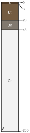
Worfka
(35%)
Shallow Loamy (SwLy) 15-19 Northern Plains Precipitation Zone
Ustic Haplargids
Well drained
Hydric: No
PAWS: 7 cm
hills / Summit
hills / Shoulder
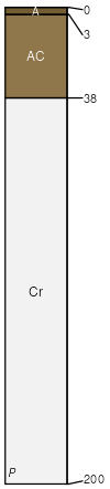
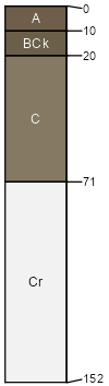
Samday
(25%)
Shallow Clayey (SwCy) 15-19 Northern Plains Precipitation Zone
Ustic Torriorthents
Well drained
Hydric: No
PAWS: 7 cm
hills / Summit
hills / Shoulder
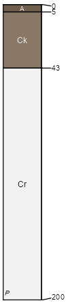
Shingle
(25%)
Shallow Loamy (SwLy) 15-19 Northern Plains Precipitation Zone
Ustic Torriorthents
Well drained
Hydric: No
PAWS: 10 cm
hills / Summit
hills / Shoulder
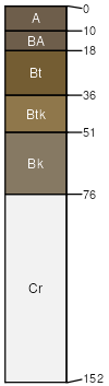
Renohill
(5%)
Clayey (Cy) 15-19 Northern Plains Precipitation Zone
Ustic Haplargids
Well drained
Hydric: No
PAWS: 16 cm
hills / Summit
hills / Shoulder
hills / Backslope
Theedle
(5%)
Loamy (Ly) 15-19 Northern Plains Precipitation Zone
Ustic Torriorthents
Well drained
Hydric: No
PAWS: 12 cm
hills / Summit
hills / Shoulder
hills / Backslope
Rock outcrop
(5%)
Hydric: No
PAWS: NA
SSA
Scale
Published
Export
wy633
1:24,000
1987
2025-09-04