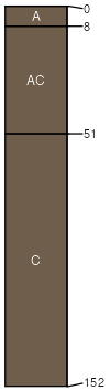
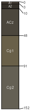
Sully (85%)
Thin Upland
Typic Ustorthents
Well drained
Hydric: No
PAWS: 28 cm |
hills / Shoulder hills / Backslope
|
|
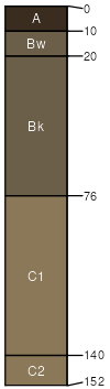
Betts (5%)
Thin Upland
Typic Ustorthents
Well drained
Hydric: No
PAWS: 29 cm |
|
|
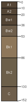
Lowry (5%)
Loamy
Typic Haplustolls
Well drained
Hydric: No
PAWS: 29 cm |
|
|
Schamber (3%)
Very Shallow
Ustic Torriorthents
Well drained
Hydric: No
PAWS: 8 cm |
|
|
Egas (1%)
Saline Lowland
Typic Haplaquolls
Poorly drained
Hydric: Yes
PAWS: 17 cm |
|
|
Hoven (1%)
Closed Depression
Vertic Natraquolls
Poorly drained
Hydric: Yes
PAWS: 22 cm |
closed depressions / Toeslope
|
|