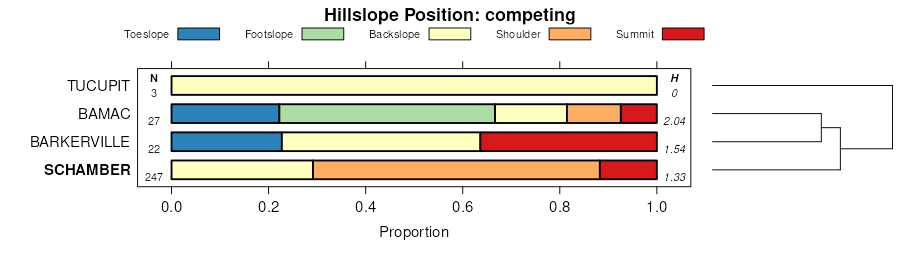
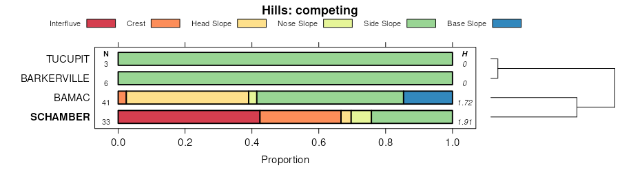
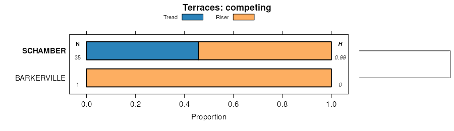
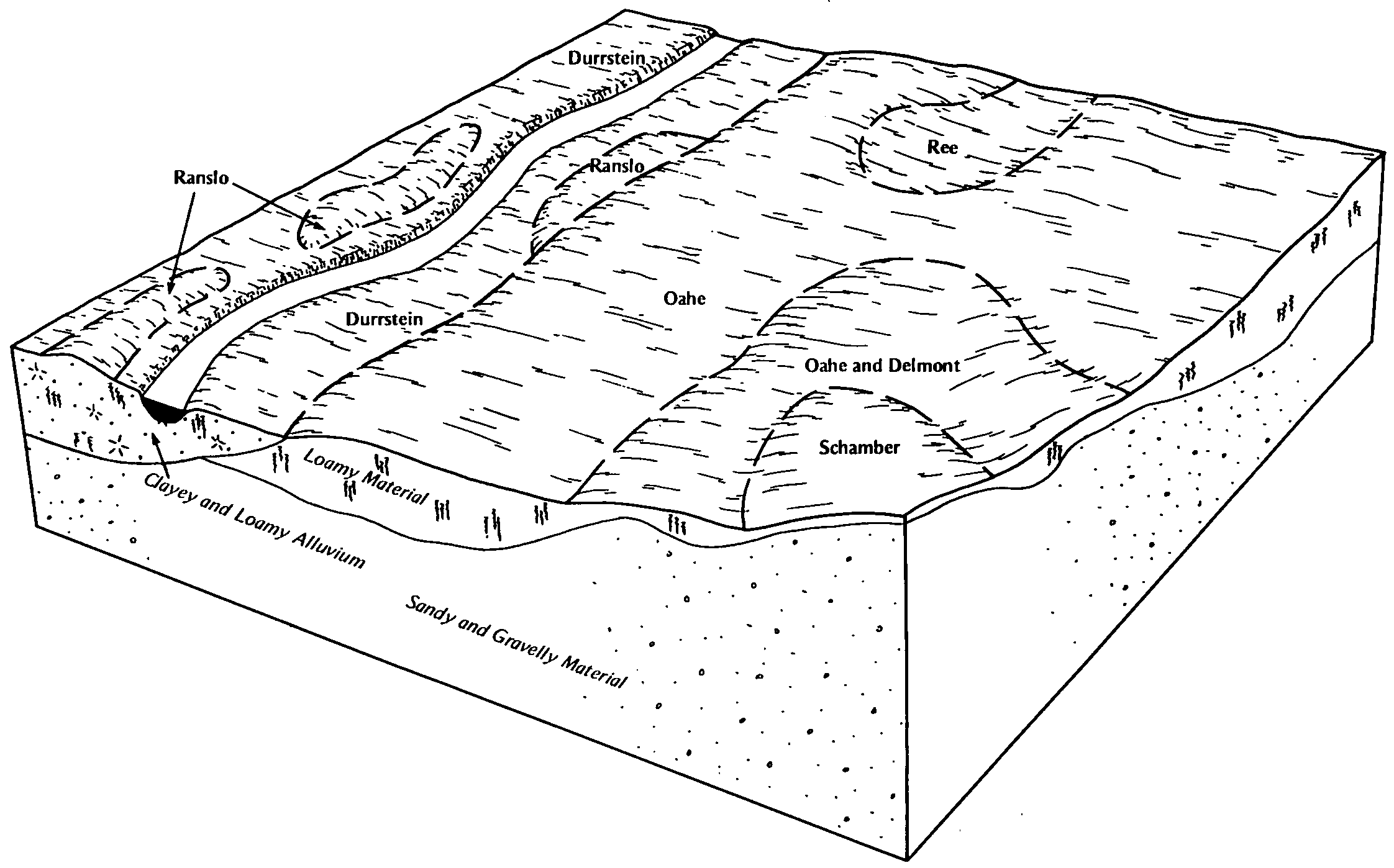
| Schamber-Stoneham complex, 6 to 35 percent slopes | 40 | 4541 | 94330 | 354x | co017 | 1985 | 1:24000 |
Schamber-Razor complex, 8 to 50 percent slopes | 82 | 18148 | 95447 | 369y | co625 | 1975 | 1:24000 |
Schamber gravelly sandy loam, 3 to 15 percent slopes | 76 | 5967 | 496516 | jnnn | co627 | 1980 | 1:24000 |
Otero-Schamber complex, 5 to 20 percent slopes | 1712 | 1312 | 1152331 | 17p2z | ks055 | 1962 | 1:24000 |
Otero-Schamber complex, warm, 5 to 20 percent slopes | 1712 | 1295 | 1380669 | 2y7zf | ks067 | 1965 | 1:24000 |
Schamber gravelly sandy loam, 5 to 25 percent slopes | 1820 | 1364 | 1380601 | 1hbmj | ks069 | 1965 | 1:24000 |
Otero-Schamber complex, warm, 5 to 20 percent slopes | 1712 | 2313 | 1380626 | 2y7zf | ks081 | 1965 | 1:24000 |
Otero-Schamber complex, 5 to 20 percent slopes | 1712 | 947 | 1152390 | 17p4w | ks083 | 1966 | 1:24000 |
Otero-Schamber complex, 5 to 20 percent slopes | 1712 | 5126 | 1152275 | 17p15 | ks093 | 1961 | 1:24000 |
Schamber gravelly sandy loam, 5 to 25 percent slopes | 1820 | 1405 | 1152284 | 17p1g | ks093 | 1961 | 1:24000 |
Schamber gravelly sandy loam, 5 to 25 percent slopes | 1820 | 1105 | 1152045 | 17nsr | ks101 | 1966 | 1:24000 |
Schamber gravelly sandy loam, 5 to 25 percent slopes | 1820 | 3342 | 1150545 | 17m7c | ks109 | 1962 | 1:24000 |
Otero-Schamber complex, warm, 5 to 20 percent slopes | 1712 | 19891 | 1382631 | 2y7zf | ks175 | 1963 | 1:24000 |
Schamber gravelly loam, warm, 5 to 25 percent slopes | 1820 | 2022 | 1382639 | 2y7zj | ks175 | 1963 | 1:24000 |
Schamber gravelly sandy loam, 5 to 25 percent slopes | 1820 | 1132 | 1150466 | 17m4t | ks193 | 1978 | 1:24000 |
Schamber soils, 3 to 30 percent slopes | 5254 | 2443 | 358165 | d0pq | ne045 | 1973 | 1:20000 |
Schamber gravelly sandy loam, 9 to 30 percent slopes | 5252 | 767 | 357734 | d07t | ne103 | 1977 | 1:20000 |
Schamber gravelly sandy loam, 3 to 30 percent slopes | 5253 | 2832 | 358023 | d0k4 | ne165 | 1993 | 1:20000 |
Schamber loam, 6 to 25 percent slopes | SeE | 4045 | 353236 | cvkq | sd019 | 1970 | 1:24000 |
Nihill-Schamber gravelly loams, moist, 6 to 30 percent slopes | P268E | 53 | 2668887 | 2rvfc | sd019 | 1970 | 1:24000 |
Schamber-Sansarc complex, 6 to 40 percent slopes | SwF | 11393 | 354241 | 2zk3x | sd041 | 1972 | 1:24000 |
Schamber gravelly sandy loam, 3 to 15 percent slopes | SdC | 2671 | 354240 | cwm3 | sd041 | 1972 | 1:24000 |
Schamber-Eckley complex, 9 to 40 percent slopes | SmE | 5541 | 355153 | cxkk | sd047 | 1980 | 1:24000 |
Schamber-Eckley complex, 9 to 40 percent slopes | P454E | 947 | 2733156 | 2rxvc | sd047 | 1980 | 1:24000 |
Schamber-Samsil complex, 6 to 60 percent slopes | StF | 28977 | 354162 | cwjl | sd055 | 1992 | 1:24000 |
Schamber-Orton complex | Sf | 6906 | 353332 | cvnt | sd065 | 1970 | 1:20000 |
Nihill-Schamber gravelly loams, moist, 6 to 30 percent slopes | P268E | 1603 | 2733284 | 2rvfc | sd081 | 2007 | 1:24000 |
Schamber gravelly loam, 6 to 25 percent slopes | 641D | 96 | 1900525 | 21sn8 | sd081 | 2007 | 1:24000 |
Schamber loam, 6 to 40 percent slopes | ShE | 3155 | 355622 | cy1p | sd085 | 1984 | 1:20000 |
Sansarc-Opal-Schamber complex, 6 to 30 percent slopes | SoE | 3096 | 2615643 | 2rmj5 | sd085 | 1984 | 1:20000 |
Sansarc-Schamber complex, 9 to 35 percent slopes | SeE | 586 | 355621 | 2wfq9 | sd085 | 1984 | 1:20000 |
Sansarc-Schamber complex, 9 to 35 percent slopes | SnE | 26727 | 353438 | 2wfq9 | sd095 | 1971 | 1:20000 |
Schamber-Sansarc complex, 6 to 40 percent slopes | SwF | 9938 | 353445 | 2zk3x | sd095 | 1971 | 1:20000 |
Schamber-Murdo gravelly loams, 15 to 25 percent slopes | SvE | 7208 | 353444 | cvsf | sd095 | 1971 | 1:20000 |
Murdo-Schamber gravelly loams, 9 to 15 percent slopes | MuD | 4680 | 353405 | cvr5 | sd095 | 1971 | 1:20000 |
Delmont-Schamber complex, 6 to 15 percent slopes | DsD | 1742 | 355321 | cxqz | sd107 | 1983 | 1:20000 |
Java-Schamber complex, 9 to 25 percent slopes | JmE | 1533 | 355343 | 30t2w | sd107 | 1983 | 1:20000 |
Schamber gravelly loam, 15 to 60 percent slopes | ScF | 882 | 355373 | cxsn | sd107 | 1983 | 1:20000 |
Schamber gravelly loam, 9 to 40 percent slopes | ShE | 7097 | 353515 | cvvq | sd117 | 1977 | 1:24000 |
Schamber-Murdo complex, 15 to 40 percent slopes | SmE | 5784 | 353517 | 2xfy6 | sd117 | 1977 | 1:24000 |
Schamber-Murdo complex, 6 to 15 percent slopes | SmD | 4491 | 353516 | cvvr | sd117 | 1977 | 1:24000 |
Schamber-Dix complex, 9 to 25 percent slopes | Gr | 1002 | 352992 | cv9v | sd121 | 1967 | 1:31680 |
Schamber-Murdo complex, 15 to 40 percent slopes | SmE | 5225 | 354447 | 2xfy6 | sd123 | 1975 | 1:20000 |
Schamber-Samsil complex, 9 to 40 percent slopes | ShE | 6524 | 355890 | cybb | sd137 | 1985 | 1:24000 |
Schamber loam, 9 to 30 percent slopes | ScE | 3633 | 355545 | cxz6 | sd603 | 1983 | 1:20000 |
Sully-Schamber complex, 9 to 25 percent slopes | SsE | 2021 | 355549 | cxzb | sd603 | 1983 | 1:20000 |
Orton-Schamber loams, 9 to 25 percent slopes | OwE | 1495 | 355536 | cxyx | sd603 | 1983 | 1:20000 |
Schamber-Samsil complex, 15 to 40 percent slopes | StE | 9866 | 2580977 | cykl | sd606 | 2011 | 1:24000 |
Schamber-Sawdust, warm-Rock outcrop complex, 40 to 80 percent slopes | P456G | 303 | 2745665 | 2rxvd | sd607 | 2011 | 1:24000 |
Schamber-Tullock complex, 3 to 30 percent slopes | 187 | 2749 | 349687 | cqw7 | wy027 | 1993 | 1:24000 |

