Scatter-Fordprairie complex, 0 to 8 percent slopes
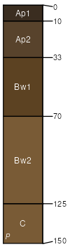
Scatter
(60%)
Puget Lowlands Riparian Forest
Andic Haploxerolls
Well drained
Hydric: No
PAWS: 18 cm
natural levees
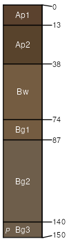
Fordprairie
(30%)
Puget Lowlands Riparian Forest
Fluvaquentic Haploxerolls
Moderately well drained
Hydric: No
PAWS: 25 cm
flood plains
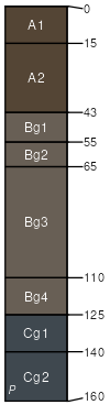
Roundtree
(5%)
Puget Lowlands Riparian Forest
Fluvaquentic Humaquepts
Poorly drained
Hydric: Yes
PAWS: 24 cm
overflow stream channels
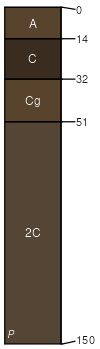
Xerofluvents
(5%)
Puget Lowlands Riparian Forest
Somewhat poorly drained
Hydric: No
PAWS: 5 cm
bars
SSA
Scale
Published
Export
wa641
1:24,000
1980
2025-08-28