Hillon-Joplin loams, 8 to 25 percent slopes
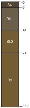
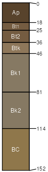
Hillon
(55%)
Silty-Steep (SiStp) 10-14 p.z.
Limy-Steep (Lystp) Dry Grassland
Limy-Steep (Lystp) Dry Shrubland
Aridic Ustorthents
Well drained
Hydric: No
PAWS: 29 cm
hillslopes / Shoulder
hillslopes / Backslope
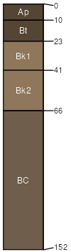
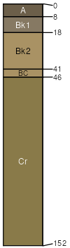
Joplin
(30%)
Silty-Steep (SiStp) 10-14 p.z.
Loamy-Steep (Lostp) Dry Grassland
Loamy-Steep (Lostp) Dry Shrubland
Aridic Argiustolls
Well drained
Hydric: No
PAWS: 32 cm
hillslopes / Backslope
hillslopes / Footslope
Hillon
(8%)
Silty (Si) 10-14 p.z.
Limy (Ly) Dry Grassland
Limy (Ly) Dry Shrubland
Aridic Ustorthents
Well drained
Hydric: No
PAWS: 29 cm
hillslopes / Shoulder
Chinook
(2%)
Sandy (Sy) Dry Grassland
Sandy (Sy) Dry Shrubland
Aridic Haplustolls
Well drained
Hydric: No
PAWS: 20 cm
hillslopes / Shoulder
hillslopes / Backslope
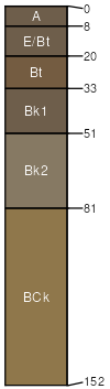
Ferd
(2%)
Silty (Si) 10-14 p.z.
Swale (Se) Dry Grassland
Swale (Se) Dry Shrubland
Aridic Haplustalfs
Well drained
Hydric: No
PAWS: 24 cm
hillslopes
Telstad
(2%)
Silty (Si) 10-14 p.z.
Loamy (Lo) Dry Grassland
Loamy (Lo) Dry Shrubland
Aridic Argiustolls
Well drained
Hydric: No
PAWS: 32 cm
hillslopes / Summit
Cabbart
(1%)
Shallow (Sw) 10-14 p.z.
Thin Breaks (TB) Dry Grassland
Thin Breaks (TB) Dry Shrubland
Aridic Ustorthents
Well drained
Hydric: No
PAWS: 8 cm
hillslopes / Backslope
hillslopes / Footslope
SSA
Scale
Published
Export
mt051
1:24,000
1992
2025-08-28