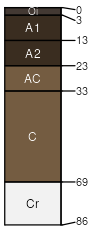
Cagwin (45%)
Frigid Mountains <40ppt
Dystric Xeropsamments
Somewhat excessively drained
Hydric: No
PAWS: 8 cm |

mountain slopes / Backslope
|
|
|
Rock outcrop (15%)
Hydric: No
PAWS: NA |

mountain slopes / Shoulder
|
|
Typic Humixerepts (3%)
Frigid Mountains <40ppt
Typic Humixerepts
Well drained
Hydric: No
PAWS: 12 cm |

mountain slopes / Backslope
|
|
|
Sirretta (3%)
Frigid Mountains <40ppt
Dystric Xerorthents
Excessively drained
Hydric: No
PAWS: 3 cm |

mountain slopes / Backslope
|
|
Cannell (3%)
Frigid Mountains <40ppt
Typic Dystroxerepts
Well drained
Hydric: No
PAWS: 13 cm |

mountain slopes / Backslope
|
|
|