Kezar-Beenom,exposed complex, 5 to 45 percent slopes
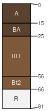
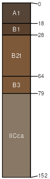
Kezar
(40%)
Mountain Loam Gunnison Basin LRU
Ustic Argicryolls
Well drained
Hydric: No
PAWS: 18 cm
hillslopes / Shoulder
hillslopes / Backslope
hillslopes / Footslope
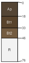
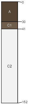
Beenom
(20%)
Dry Exposure Gunnison Basin LRU
Aridic Lithic Argiustolls
Well drained
Hydric: No
PAWS: 5 cm
hillslopes / Summit
hillslopes / Shoulder
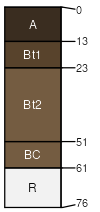
Duffson
(10%)
Dry Mountain Loam Gunnison Basin LRU
Aridic Argiustolls
Well drained
Hydric: No
PAWS: 9 cm
hillslopes / Shoulder
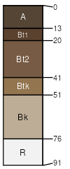
Woodhall
(10%)
Spruce-Fir Woodland
Ustic Argicryolls
Well drained
Hydric: No
PAWS: 6 cm
hillslopes / Shoulder
hillslopes / Backslope
Rock outcrop
(10%)
Hydric: No
PAWS: NA
Parlin
(5%)
Deep Clay Loam Shale Highlands LRU
Ustic Argicryolls
Well drained
Hydric: No
PAWS: 12 cm
hills / Backslope
hills / Footslope
Hopkins
(5%)
Stony Loam
Ustic Haplocryolls
Somewhat excessively drained
Hydric: No
PAWS: 6 cm
hills / Backslope
hills / Footslope
SSA
Scale
Published
Export
co662
1:24,000
1968
2025-09-02