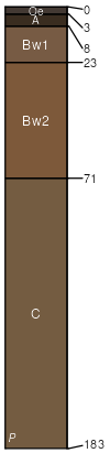
Arnot (45%)
Shallow Till Uplands
Lithic Dystrudepts
Somewhat excessively drained
Hydric: No
PAWS: 5 cm |
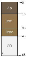
hills / Summit hills / Shoulder hills / Backslope
|
|
Oquaga (40%)
Well Drained Till Uplands
Typic Dystrudepts
Well drained
Hydric: No
PAWS: 9 cm |
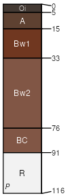
hills / Summit hills / Shoulder hills / Backslope
|
|
Wellsboro (5%)
Typic Fragiudepts
Moderately well drained
Hydric: No
PAWS: 11 cm |
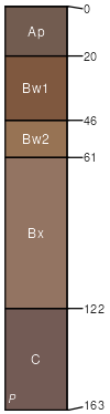
hills / Summit hills / Shoulder
|
|
Rock outcrop (5%)
Hydric: No
PAWS: NA |

mountains hills / Summit hills / Shoulder hills / Backslope
|
|
Tuller (3%)
Lithic Haplaquepts
Somewhat poorly drained
Hydric: No
PAWS: 4 cm |
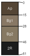
hills / Summit hills / Footslope benches / Footslope ridges / Footslope
|
|
Cadosia (2%)
Typic Dystrudepts
Well drained
Hydric: No
PAWS: 18 cm |
ridges / Backslope ridges / Footslope
|
|