Westmoreland-Coshocton complex, 8 to 15 percent slopes, eroded
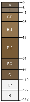
Westmoreland
(50%)
Acid Mixed Sedimentary Upland
Ultic Hapludalfs
Well drained
Hydric: No
PAWS: 21 cm
hills / Summit
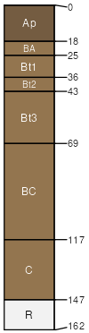
Coshocton
(40%)
Acid Mixed Sedimentary Upland
Aquultic Hapludalfs
Moderately well drained
Hydric: No
PAWS: 19 cm
hills / Summit
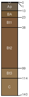
Rigley
(5%)
Hydric:
PAWS: NA
hills
somewhat poorly drained soils
(5%)
Hydric:
PAWS: NA
SSA
Scale
Published
Export
oh075
1:16,000
1989
2025-08-29