Redgap-Subwater complex, 0 to 5 percent slopes
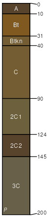
Redgap
(65%)
Sandy Green River and Great Divide Basins (Sy)
Sodic Ustic Haplocambids
Well drained
Hydric: No
PAWS: 17 cm
hillslopes / Summit
Subwater
(30%)
Saline Upland Green River and Great Divide Basins (SU)
Ustic Natrargids
Well drained
Hydric: No
PAWS: 17 cm
hillslopes / Summit
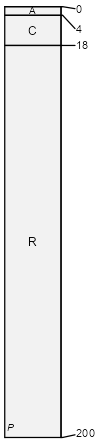
Crownest
(5%)
Shallow Loamy Calcareous Foothills and Basins West (SwLyCa)
Lithic Ustic Torriorthents
Well drained
Hydric: No
PAWS: 3 cm
hillslopes / Summit
SSA
Scale
Published
Export
wy635
1:24,000
2025-09-04