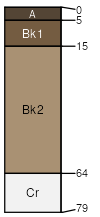
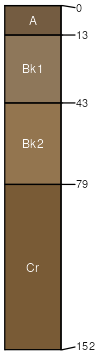
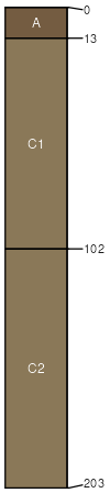
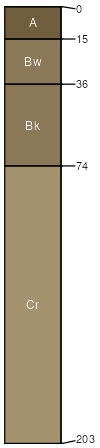
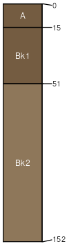
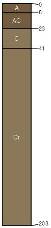
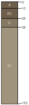
Turnercrest, moist-Ucross-Sodawells, occasionally flooded complex, 2 to 40 percent slopes

Turnercrest (31%)
Sandy
Aridic Ustorthents
Well drained
Hydric: No
PAWS: 9 cm
hillslopes / Backslope
Ucross (29%)
Loamy-West (16-20 PZ)
Aridic Ustorthents
Well drained
Hydric: No
PAWS: 12 cm
hillslopes
Sodawells (20%)
Lowland (LL) 15-19 Precipitation Zone, Black Hills
Aridic Ustifluvents
Well drained
Hydric: No
PAWS: 19 cm
drainageways / Toeslope
flood plains / Toeslope
Cromack (5%)
Clayey-West (16-20 PZ)
Torrertic Ustorthents
Well drained
Hydric: No
PAWS: 13 cm
hillslopes / Backslope
Fairburn (5%)
Shallow Loamy-West (16-20 PZ)
Aridic Ustorthents
Well drained
Hydric: No
PAWS: 10 cm
ridges / Summit
ridges / Shoulder
Mittenbutte (5%)
Shallow Sandy-West (16-20 PZ)
Aridic Ustorthents
Well drained
Hydric: No
PAWS: 7 cm
ridges / Summit
ridges / Shoulder
Iwait (5%)
Thin Upland-North (18-22 PZ)
Aridic Ustorthents
Well drained
Hydric: No
PAWS: 26 cm
alluvial fans / Footslope
SSAScalePublishedExport
sd0191:24,00019702023-09-11