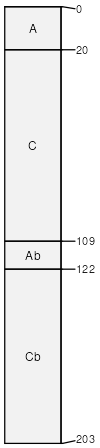
Miskoaki (40%)
Clayey Uplands
Vertic Glossudalfs
Well drained
Hydric: No
PAWS: 20 cm |
till plains / Shoulder till plains / Backslope
|
|
|
Rock outcrop (11%)
Hydric: Unranked
PAWS: NA |

drainageways escarpments moraines
|
|
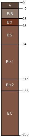
Amnicon (10%)
Clayey Uplands
Lithic Hapludalfs
Moderately well drained
Hydric: No
PAWS: 7 cm |
|
|
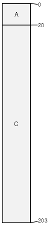
Oxyaquic Udifluvents (10%)
Oxyaquic Udifluvents
Moderately well drained
Hydric: No
PAWS: 19 cm |
|
|
Rock outcrop flooded (9%)
Hydric: Unranked
PAWS: NA |
channels flood plains / Shoulder flood plains / Backslope
|
|
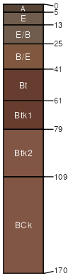
Cuttre (5%)
Wet Loamy or Clayey Lowlands
Aeric Glossaqualfs
Somewhat poorly drained
Hydric: No
PAWS: 21 cm |
till plains / Shoulder till plains / Footslope
|
|