| Sandy alluvial land, poorly to somewhat poorly drained | Sa | 45392 | 122765 | 43r5 | al017 | 1957 | 1:20000 |
Udifluvents, 4 to 25 percent slopes, channeled | 63 | 5108 | 329103 | c1g7 | al047 | 1977 | 1:20000 |
Udifluvents-Fluvaquents complex, 0 to 3 percent slopes, frequently flooded | UfA | 1857 | 2995053 | 2x5qt | al097 | 2018 | 1:24000 |
Mixed alluvial land (guyton) | Ma | 30832 | 565159 | lz2y | ar011 | 1959 | 1:20000 |
Wehadkee soils, and Udifluvents | Wb | 38528 | 565339 | lz8r | ar025 | 1965 | 1:15840 |
Udifluvents, cobbly | Cy | 1033 | 565536 | lzh3 | ar047 | 1967 | 1:20000 |
Udifluvents | Ad | 1790 | 564333 | ly79 | ar093 | 1967 | 1:20000 |
Udifluvents, 0 to 2 percent slopes | 132 | 1327 | 470005 | hs2g | ca600 | 2017 | 1:24000 |
Pits and Udifluvents soils, 0 to 15 percent slopes | 395 | 19 | 470025 | 2rshm | ca600 | 2017 | 1:24000 |
Pits and Udifluvents soils, 0 to 15 percent slopes | 395 | 126 | 2670234 | 2rshm | ca605 | 2013 | 1:24000 |
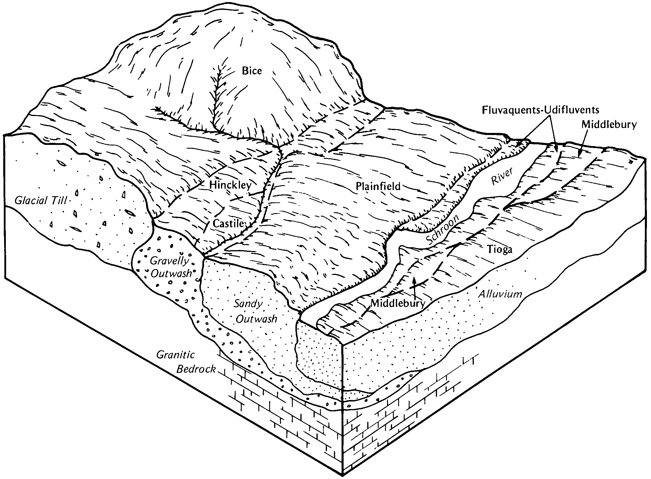
Fluvaquents-Udifluvents complex, frequently flooded | 109 | 5257 | 3395644 | 9ljw | ct601 | 2003 | 1:12000 |
Fluvaquents-Udifluvents complex, frequently flooded | 109 | 3185 | 3396017 | 9ljw | ct602 | 2003 | 1:12000 |
Fluvaquents-Udifluvents-Urban land complex | FH | 106 | 128600 | 49td | dc001 | 1975 | 1:12000 |
Fluvaquents-Udifluvents complex, frequently flooded | FF | 56 | 128599 | 49tc | dc001 | 1975 | 1:12000 |
Udifluvents, sandy | UA | 52 | 128671 | 49wp | dc001 | 1975 | 1:12000 |
Udifluvents | 39 | 2410 | 1151433 | 17n50 | fl051 | 1986 | 1:24000 |
Udifluvents-Kuanene complex, 2 to 10 percent slopes | 557 | 2167 | 2371292 | 2klj9 | hi801 | 2012 | 1:24000 |
Spillville-Udifluvents complex, channeled, 0 to 2 percent slopes | 1936 | 5957 | 403999 | fkd7 | ia037 | 1989 | 1:15840 |
Udifluvents, loamy, 0 to 2 percent slopes | 315 | 1994 | 405416 | flvy | ia061 | 1983 | 1:15840 |
Spillville-Udifluvents complex, channeled, 0 to 2 percent slopes | 1936 | 106 | 2475356 | 2p2t6 | ia065 | 1975 | 1:15840 |
Spillville-Udifluvents complex, channeled, 0 to 2 percent slopes | 1936 | 79 | 2474573 | 2p1zy | ia089 | 1969 | 1:15840 |
Udifluvents-Fluvaquents complex, 0 to 2 percent slopes, flaggy, frequently flooded | 5050 | 833 | 409191 | 2xbm3 | ia121 | 1968 | 1:15840 |
Udifluvents, loamy, 2 to 5 percent slopes, occasionally flooded | 315B | 1103 | 1453488 | 1ksgq | ia187 | 2006 | 1:12000 |
Udifluvents-Spillville complex, channeled, 0 to 2 percent slopes, frequently flooded | 1936 | 2761 | 1400311 | 1j04b | ia191 | 2005 | 1:12000 |
Urban land-Udifluvents complex, leveed, 0 to 2 percent slopes | UndAY | 129 | 210848 | 72dk | in019 | 2001 | 1:12000 |
Urban land-Udifluvents complex, leveed, 0 to 2 percent slopes | UndAY | 187 | 185202 | 66q8 | in043 | 2000 | 1:12000 |
Udifluvents, 1 to 20 percent slopes | UA | 7043 | 1413698 | 1jg25 | la019 | 1983 | 1:24000 |
Udifluvents, 1 to 20 percent slopes | UD | 8134 | 1723531 | 1vvgs | la023 | 1986 | 1:24000 |
Udifluvents, loamy | UD | 957 | 1722430 | 1vtb8 | la025 | 1983 | 1:24000 |
Udifluvents, loamy | UDA | 670 | 808629 | w4ft | la055 | 1976 | 1:24000 |
Udifluvents | Ud | 723 | 808560 | w4cl | la065 | 1972 | 1:24000 |
Spoil areas | Sp | 179 | 1604652 | 1qvrz | la079 | 1973 | 1:24000 |
Udifluvents, 1 to 20 percent slopes | UD | 2165 | 1539721 | 1np6f | la113 | 1988 | 1:24000 |
Udifluvents, frequently flooded | 615 | 92 | 278965 | 9c8w | ma011 | 2012 | 1:12000 |
Haplaquolls and Udifluvents, level | 1001 | 428 | 356932 | czdy | mn027 | 1980 | 1:20000 |
Odanah-Udifluvents, frequently flooded-Rock outcrop complex, 1 to 70 percent slopes | E1-30F | 3149 | 2774521 | 2rn1n | mn031 | 2013 | 1:24000 |
Odanah-Udifluvents, frequently flooded complex, 1 to 45 percent slopes | E2-24E | 2187 | 2774480 | 2t575 | mn031 | 2013 | 1:24000 |
Entisols, frequently flooded, rubbly and Histosols soils, 0 to 1 percent slopes, ponded | K2-12 | 1479 | 2774695 | 2t224 | mn031 | 2013 | 1:24000 |
Udifluvents complex, 0 to 3 percent slopes, flooded | K2-15A | 1083 | 2774712 | 2t227 | mn031 | 2013 | 1:24000 |
Forbay-Udifluvents, frequently flooded-Rock outcrop complex, 1 to 18 percent slopes | E1-19D | 1032 | 2774528 | 2rn1h | mn031 | 2013 | 1:24000 |
Sanborg-Udifluvents, frequently flooded complex, 1 to 18 percent slopes | E2-22D | 896 | 2774593 | 2t573 | mn031 | 2013 | 1:24000 |
Ahmeek-Rock outcrop-Udifluvents, frequently flooded complex, 1 to 70 percent slopes | E1-14F | 765 | 2774506 | 2rn0y | mn031 | 2013 | 1:24000 |
Forbay-Udifluvents, frequently flooded-Rock outcrop complex, 1 to 70 percent slopes | E1-20E | 722 | 2774561 | 2rn1c | mn031 | 2013 | 1:24000 |
Fluvaquents-Udifluvents complex, 0 to 3 percent slopes, frequently flooded, rubbly | K2-11A | 505 | 2774658 | 2t223 | mn031 | 2013 | 1:24000 |
Ahmeek-Udifluvents, frequently flooded-Rock outcrop complex, 1 to 18 percent slopes | E1-9D | 152 | 2774479 | 2rn1d | mn031 | 2013 | 1:24000 |
Forbay-Udifluvents, frequently flooded complex, 1 to 18 percent slopes | E2-12D | 138 | 2774717 | 2t56y | mn031 | 2013 | 1:24000 |
Sanborg-Udifluvents, frequently flooded-Rock outcrop complex, 1 to 18 percent slopes | E1-28D | 106 | 2774657 | 2rn1l | mn031 | 2013 | 1:24000 |
Forbay-Udifluvents, frequently flooded complex, 1 to 45 percent slopes | E2-14E | 96 | 2774557 | 2t570 | mn031 | 2013 | 1:24000 |
Udifluvents complex, 0 to 2 percent slopes, occasionally flooded | K2-13A | 38 | 2774535 | 2t225 | mn031 | 2013 | 1:24000 |
Miskoaki-Udifluvents, frequently flooded-Rock outcrop complex, 1 to 45 percent slopes | E1-40E | 3214 | 2742178 | 2rn0z | mn075 | 2013 | 1:24000 |
Entisols, frequently flooded, rubbly and Histosols soils, 0 to 1 percent slopes, ponded | K2-12 | 2380 | 2774467 | 2t224 | mn075 | 2013 | 1:24000 |
Fluvaquents-Udifluvents complex, 0 to 3 percent slopes, frequently flooded, rubbly | K2-11A | 2348 | 2774466 | 2t223 | mn075 | 2013 | 1:24000 |
Udifluvents complex, 0 to 3 percent slopes, flooded | K2-15A | 1819 | 2774470 | 2t227 | mn075 | 2013 | 1:24000 |
Miskoaki-Udifluvents, frequently flooded complex, 1 to 45 percent slopes | E2-34E | 1281 | 2742207 | 2t57b | mn075 | 2013 | 1:24000 |
Ahmeek-Udifluvents, frequently flooded-Rock outcrop complex, 1 to 18 percent slopes | E1-9D | 869 | 2742182 | 2rn1d | mn075 | 2013 | 1:24000 |
Ahmeek-Rock outcrop-Udifluvents, frequently flooded complex, 1 to 70 percent slopes | E1-14F | 863 | 2742179 | 2rn0y | mn075 | 2013 | 1:24000 |
Forbay-Udifluvents, frequently flooded-Rock outcrop complex, 1 to 70 percent slopes | E1-20E | 828 | 2742186 | 2rn1c | mn075 | 2013 | 1:24000 |
Amnicon-Udifluvents, frequently flooded complex, 1 to 18 percent slopes | E2-32D | 644 | 2742205 | 2t578 | mn075 | 2013 | 1:24000 |
Forbay-Udifluvents, frequently flooded complex, 1 to 45 percent slopes | E2-14E | 433 | 2742197 | 2t570 | mn075 | 2013 | 1:24000 |
Forbay-Udifluvents, frequently flooded complex, 1 to 18 percent slopes | E2-12D | 314 | 2742195 | 2t56y | mn075 | 2013 | 1:24000 |
Udifluvents complex, 0 to 2 percent slopes, occasionally flooded | K2-13A | 285 | 2774468 | 2t225 | mn075 | 2013 | 1:24000 |
Forbay-Udifluvents, frequently flooded-Rock outcrop complex, 1 to 18 percent slopes | E1-19D | 257 | 2742185 | 2rn1h | mn075 | 2013 | 1:24000 |
Odanah-Udifluvents, frequently flooded complex, 1 to 45 percent slopes | E2-24E | 225 | 2742202 | 2t575 | mn075 | 2013 | 1:24000 |
Odanah-Udifluvents, frequently flooded-Rock outcrop complex, 1 to 70 percent slopes | E1-30F | 187 | 2742190 | 2rn1n | mn075 | 2013 | 1:24000 |
Sanborg-Udifluvents, frequently flooded complex, 1 to 18 percent slopes | E2-22D | 185 | 2742200 | 2t573 | mn075 | 2013 | 1:24000 |
Udifluvents complex, 0 to 2 percent slopes, rarely flooded | K2-16A | 127 | 2774471 | 2t228 | mn075 | 2013 | 1:24000 |
Amnicon-Udifluvents, frequently flooded-Rock outcrop complex, 1 to 18 percent slopes | E1-38D | 28 | 2742192 | 2t56v | mn075 | 2013 | 1:24000 |
Sanborg-Udifluvents, frequently flooded-Rock outcrop complex, 1 to 18 percent slopes | E1-28D | 3 | 2742188 | 2rn1l | mn075 | 2013 | 1:24000 |
Udifluvents and Fluvaquents, loamy, 0 to 2 percent slopes, occasionally flooded | 1026A | 515 | 1676341 | 1t8cj | mn095 | 2006 | 1:12000 |
Fluvaquents and Udifluvents, loamy, 0 to 2 percent slopes, frequently flooded | 1025A | 496 | 1676340 | 1t8ch | mn095 | 2006 | 1:12000 |
Udifluvents, loamy, 0 to 2 percent slopes, occasionally flooded | C162 | 1745 | 2484673 | 2pdhr | mn115 | 2009 | 1:24000 |
Forbay-Udifluvents, frequently flooded, complex, 1 to 30 percent slopes | C257E | 91 | 3462744 | 31129 | mn115 | 2009 | 1:24000 |
Udifluvents | 1033 | 343 | 1677294 | 1t9c8 | mn123 | 1978 | 1:15840 |
Udifluvents, frequently flooded | 1018 | 1515 | 428068 | gcfn | mn145 | 1980 | 1:15840 |
Udifluvents | 1033 | 926 | 1677159 | 1t96x | mn163 | 1978 | 1:15840 |
Udifluvents complex, 0 to 3 percent slopes, flooded | E12A | 1422 | 626061 | p0gj | mn615 | 2007 | 1:24000 |
Miskoaki-Udifluvents, flooded, complex, 1 to 45 percent slopes | E23F | 1156 | 1424722 | 1jtjs | mn615 | 2007 | 1:24000 |
Udifluvents, loamy, 0 to 2 percent slopes, occasionally flooded | 1026A | 601 | 1424764 | 1jtl4 | mn615 | 2007 | 1:24000 |
Udifluvents and Fluvaquents, loamy, 0 to 2 percent slopes, rarely flooded | 1034A | 450 | 1424865 | 1jtpd | mn615 | 2007 | 1:24000 |
Amnicon-Udifluvents, frequently flooded, complex, 0 to 18 percent slopes | E10D | 307 | 626064 | p0gm | mn615 | 2007 | 1:24000 |
Udifluvents, occasionally flooded-Rollins complex, 0 to 30 percent slopes | E13E | 201 | 626060 | p0gh | mn615 | 2007 | 1:24000 |
Entisols, channeled, 0 to 20 percent slopes, rarely to frequently flooded | B66C | 1965 | 1861512 | 20h1s | mn617 | 2007 | 1:24000 |
Fluvaqents-Eutrudepts-Udifluvents complex, 0 to 35 percent slopes, flooded | B268E | 6950 | 2425681 | 2mf3s | mn619 | 2009 | 1:24000 |
Udifluvents, loamy, 0 to 2 percent slopes, occasionally flooded | 1026A | 5267 | 2438082 | 2mv0t | mn619 | 2009 | 1:24000 |
Fluvaquents-Eutrudepts-Udifluvents complex, 0 to 18 percent slopes, flooded | B268D | 3988 | 2425680 | 2mf3r | mn619 | 2009 | 1:24000 |
Entisols, channeled, 0 to 20 percent slopes, rarely to frequently flooded | B66C | 480 | 2438087 | 2mv0z | mn619 | 2009 | 1:24000 |
Entisols, channeled, 0 to 20 percent slopes, rarely to frequently flooded | B66C | 1385 | 823070 | wmgn | mn621 | 2006 | 1:24000 |
Udifluvents-Water complex | 13586 | 287 | 887595 | ysm3 | mo021 | 1984 | 1:24000 |
Udifluvents, 0 to 2 percent slopes, frequently flooded | 13584 | 195 | 887539 | ysk9 | mo087 | 1992 | 1:24000 |
Udifluvents, 0 to 2 percent slopes | 111 | 5686 | 145400 | 4w9b | mt638 | 1985 | 1:24000 |
Udifluvents, sandy, 0 to 5 percent slopes, frequently flooded | UcB | 28 | 1672106 | 1t3yx | nc021 | 2006 | 1:12000 |
Fluvaquents-Udifluvents complex, 0 to 3 percent slopes, mounded, occasionally flooded | FnA | 231 | 117002 | 3xr8 | nc023 | 2000 | 1:24000 |
Ostin-Udifluvents complex, 0 to 5 percent slopes, frequently flooded | OsB | 869 | 2679247 | 2r93c | nc027 | 2012 | 1:12000 |
Fluvaquents-Udifluvents complex, 0 to 3 percent slopes, mounded, occasionally flooded | FnA | 160 | 1907615 | 2210z | nc035 | 1969 | 1:15840 |
Udifluvents, sandy, frequently flooded | Uf | 901 | 547226 | lcfg | nc111 | 1989 | 1:24000 |
Udifluvents, sandy, 0 to 5 percent slopes, frequently flooded | UcB | 101 | 1671462 | 1t394 | nc115 | 2006 | 1:12000 |
Fluvaquents-Udifluvents complex, 0 to 2 percent slopes, occasionally flooded | FvA | 445 | 117659 | 3yfg | nc161 | 1997 | 1:24000 |
Udifluvents, sandy-skeletal, frequently flooded | Uc | 359 | 547873 | ld3b | nc199 | 1997 | 1:12000 |
Urban land-Udifluvents loamy complex, 0 to 6 percent slopes | G645B | 53 | 2573652 | 2q5vm | nd003 | 1988 | 1:20000 |
Urban land-Udifluvents loamy complex, 0 to 6 percent slopes | G645B | 725 | 2581409 | 2q5vm | nd093 | 1990 | 1:24000 |
Urban land-Udifluvents loamy complex, 0 to 6 percent slopes | F645B | 1536 | 2585193 | 2q5dx | nd101 | 1967 | 1:20000 |
Udifluvents, 0 to 3 percent slopes, frequently flooded | UcdAt | 217 | 812755 | w8qx | nj013 | 2003 | 1:12000 |
Udifluvents, 0 to 3 percent slopes, occasionally flooded | UccAs | 13 | 1469044 | 1l9nj | nj027 | 1974 | 1:24000 |
Fluvaquents and Udifluvents, 0 to 3 percent slopes, frequently flooded | FNAT | 858 | 1423578 | 1jsbw | nj031 | 1972 | 1:24000 |
Udifluvents, 0 to 3 percent slopes, occasionally flooded | UccAs | 621 | 626816 | p17w | nj037 | 2002 | 1:24000 |
Udifluvents, 0 to 3 percent slopes, frequently flooded | UcdAt | 258 | 1444067 | 1kgnt | nj039 | 1989 | 1:24000 |
Udifluvents, 0 to 3 percent slopes, occasionally flooded | UccAs | 415 | 740988 | sw1v | nj041 | 2007 | 1:12000 |
Fluvaquents-Udifluvents complex, frequently flooded | Fx | 4664 | 288730 | 9pfw | ny001 | 1985 | 1:15840 |
Udifluvents and Fluvaquents, frequently flooded, 0 to 3 percent slopes | 1A | 5212 | 1859954 | 20ffj | ny003 | 2013 | 1:24000 |
Alluvial land | Ad | 6321 | 289164 | 9pww | ny007 | 1966 | 1:15840 |
Udifluvents and Fluvaquents, frequently flooded | 1 | 6590 | 289512 | 9q83 | ny009 | 2002 | 1:24000 |
Alluvial land | Al | 3826 | 289343 | 9q2n | ny011 | 1968 | 1:15840 |
Fluvaquents-Udifluvents complex, frequently flooded | Fe | 8680 | 289827 | 9ql8 | ny013 | 1988 | 1:15840 |
Alluvial land | Ab | 7816 | 289907 | 9qnv | ny015 | 1969 | 1:20000 |
Udifluvents-Fluvaquents complex, frequently flooded | Ud | 10985 | 290042 | 9qt6 | ny017 | 1982 | 1:15840 |
Fluvaquents-Udifluvents complex, frequently flooded | Fn | 5020 | 290158 | 9qxy | ny019 | 1995 | 1:24000 |
Fluvaquents-Udifluvents complex, frequently flooded | Fn | 6674 | 290332 | 9r3k | ny021 | 1985 | 1:15840 |
Udifluvents-Fluvaquents Complex, 0 to 3 percent slopes, frequently flooded | 1A | 4375 | 2723104 | 2rwct | ny023 | 2014 | 1:12000 |
Fluvaquents-Udifluvents complex, frequently flooded | Ff | 11287 | 290483 | 9r8f | ny025 | 1999 | 1:24000 |
Fluvaquents-Udifluvents complex, frequently flooded | Ff | 3093 | 290654 | 9rfy | ny027 | 1992 | 1:24000 |
Fluvaquents and Udifluvents, frequently flooded | Fu | 10812 | 290812 | 9rm1 | ny029 | 1979 | 1:15840 |
Fluvaquents-Udifluvents complex, frequently flooded, nearly level | FuA | 2845 | 1714415 | 1vjzq | ny031 | 2007 | 1:24000 |
Fluvaquents-Udifluvents complex, frequently flooded, 0 to 3 percent slopes | FnA | 285 | 2753632 | 2spk1 | ny033 | 2018 | 1:24000 |
Udifluvents and Fluvaquents, frequently flooded | Ud | 289 | 631233 | p5vc | ny037 | 2004 | 1:24000 |
Fluvaquents-Udifluvents complex, frequently flooded | Fu | 7128 | 291631 | 9sgg | ny039 | 1985 | 1:24000 |
Alluvial land | Ad | 10344 | 2518290 | 9svp | ny043 | 2018 | 1:24000 |
Fluvaquents-Udifluvents complex, frequently flooded | Fu | 17658 | 291818 | 9snh | ny045 | 1981 | 1:15840 |
Udorthents-Udifluvents,complex | Uc | 2489 | 291925 | 9sry | ny045 | 1981 | 1:15840 |
Fluvaquents-Udifluvents complex, frequently flooded | AdA | 2235 | 2677619 | bmhb | ny049 | 2018 | 1:24000 |
Fluvaquents and Udifluvents complex, frequently flooded | RdA | 248 | 2677783 | bmnk | ny049 | 2018 | 1:24000 |
Udifluvents and Fluvaquents, 0 to 3 percent slopes, frequently flooded | 1A | 3868 | 3105631 | 2y9tt | ny051 | 2019 | 1:24000 |
Alluvial land | AL | 2674 | 292511 | 9tcv | ny053 | 1975 | 1:15840 |
Alluvial land | Al | 1719 | 292657 | 9tjk | ny055 | 1967 | 1:15840 |
Udifluvents, rarely flooded | Ua | 272 | 292938 | 9ttm | ny059 | 1983 | 1:24000 |
Udifluvents-Fluvaquents complex, frequently flooded | 1 | 8988 | 293291 | 9v60 | ny065 | 1993 | 1:24000 |
Fluvaquents-Udifluvents complex, 0 to 3 percent slopes, frequently flooded | 1A | 2565 | 2421205 | 2m8gd | ny069 | 2012 | 1:12000 |
Udifluvents-Fluvaquents complex, frequently flooded | UF | 2010 | 293983 | 9vxb | ny071 | 1976 | 1:15840 |
Udifluvents, frequently flooded | UD | 1848 | 294080 | 9w0g | ny073 | 1973 | 1:15840 |
Fluvaquents and Udifluvents, frequently flooded | FA | 7697 | 294111 | 9w1g | ny075 | 1973 | 1:15840 |
Fluvaquents-Udifluvents complex, frequently flooded | Fg | 10238 | 294211 | 9w4p | ny077 | 1993 | 1:24000 |
Fluvaquents-Udifluvents complex, frequently flooded | Ff | 3676 | 293073 | 9tyz | ny079 | 1987 | 1:12000 |
Fluvaquents-Udifluvents complex, 0 to 3 percent slopes | FlA | 9230 | 293161 | 9v1t | ny083 | 1980 | 1:15840 |
Fluvaquents-Udifluvents complex, frequently flooded | Fu | 11046 | 294942 | 9wx8 | ny089 | 1990 | 1:24000 |
Alluvial land | Al | 5907 | 294448 | 9wdb | ny095 | 1965 | 1:15840 |
Fluvaquents-Udifluvents complex, frequently flooded | FF | 2035 | 294609 | 9wkj | ny097 | 1976 | 1:15840 |
Alluvial land | Al | 1496 | 294674 | 9wmm | ny099 | 1966 | 1:15840 |
Fluvaquents-Udifluvents complex, frequently flooded | Fu | 7804 | 295069 | 9x1c | ny105 | 1984 | 1:15840 |
Alluvial soils, undifferentiated | A | 4827 | 295797 | 9xsv | ny107 | 1947 | 1:31680 |
Alluvial land | Ab | 4975 | 295575 | 9xkp | ny109 | 1963 | 1:20000 |
Alluvial land | AA | 5772 | 295444 | 9xfg | ny111 | 1974 | 1:15840 |
Fluvaquents-Udifluvents complex, frequently flooded | Fu | 5639 | 295881 | 9xwk | ny113 | 1982 | 1:15840 |
Alluvial land | AD | 1575 | 295692 | 9xpg | ny117 | 1972 | 1:15840 |
Fluvaquents-Udifluvents complex, frequently flooded | Ff | 4410 | 309707 | bd8k | ny119 | 1987 | 1:12000 |
Alluvial land | Am | 4589 | 295289 | 9x8g | ny121 | 1969 | 1:20000 |
Fluvaquents-Udifluvents complex, 0 to 3 percent slopes, frequently flooded | 1A | 945 | 3250304 | 2m8gd | ny123 | 1948 | 1:12000 |
Fluvaquents and Udifluvents, frequently flooded | Fu | 670 | 289271 | 9q0b | ny605 | 1981 | 1:24000 |
Alluvial land | Ad | 350 | 292958 | 9tv8 | ny664 | 1968 | 1:15840 |
Fluvaquents-Udifluvents complex, frequently flooded | 5 | 47 | 296049 | 9y1z | ny689 | 1999 | 1:24000 |
Udifluvents-Hapludalfs, complex 0 to 15 percent slopes | 68 | 3510 | 60924 | 21d9 | or007 | 1984 | 1:20000 |
Hapludalfs-Udifluvents complex | 24 | 9402 | 60963 | 21fk | or009 | 1983 | 1:20000 |
Udifluvents-Dystrochrepts complex | 59 | 611 | 61009 | 21h1 | or009 | 1983 | 1:20000 |
Udifluvents-Riverwash-Water complex, 0 to 3 percent slopes | 89A | 451 | 67306 | 2815 | or057 | 2006 | 1:24000 |
Udifluvents, nearly level | 40 | 2281 | 61504 | 2200 | or067 | 1975 | 1:20000 |
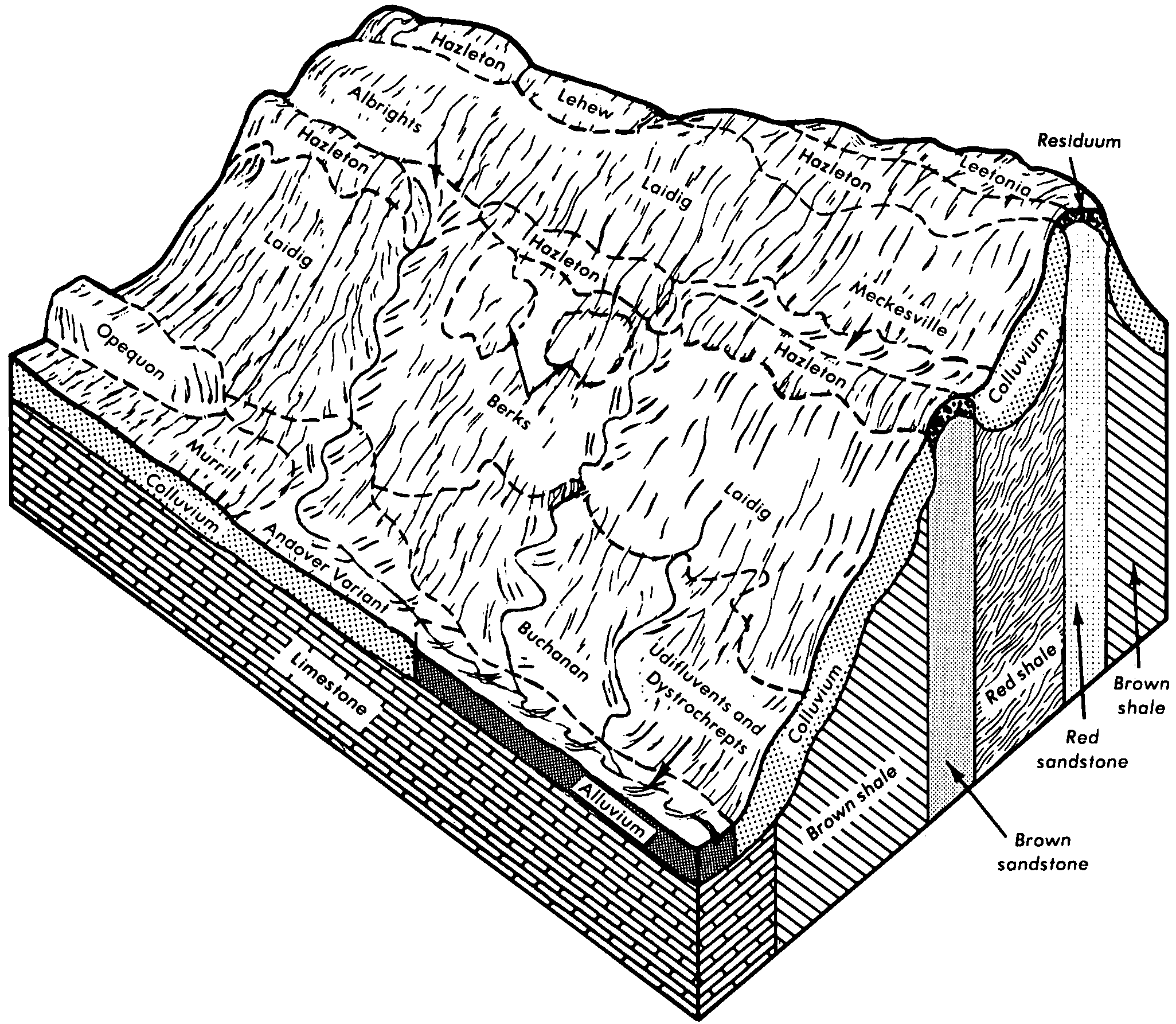
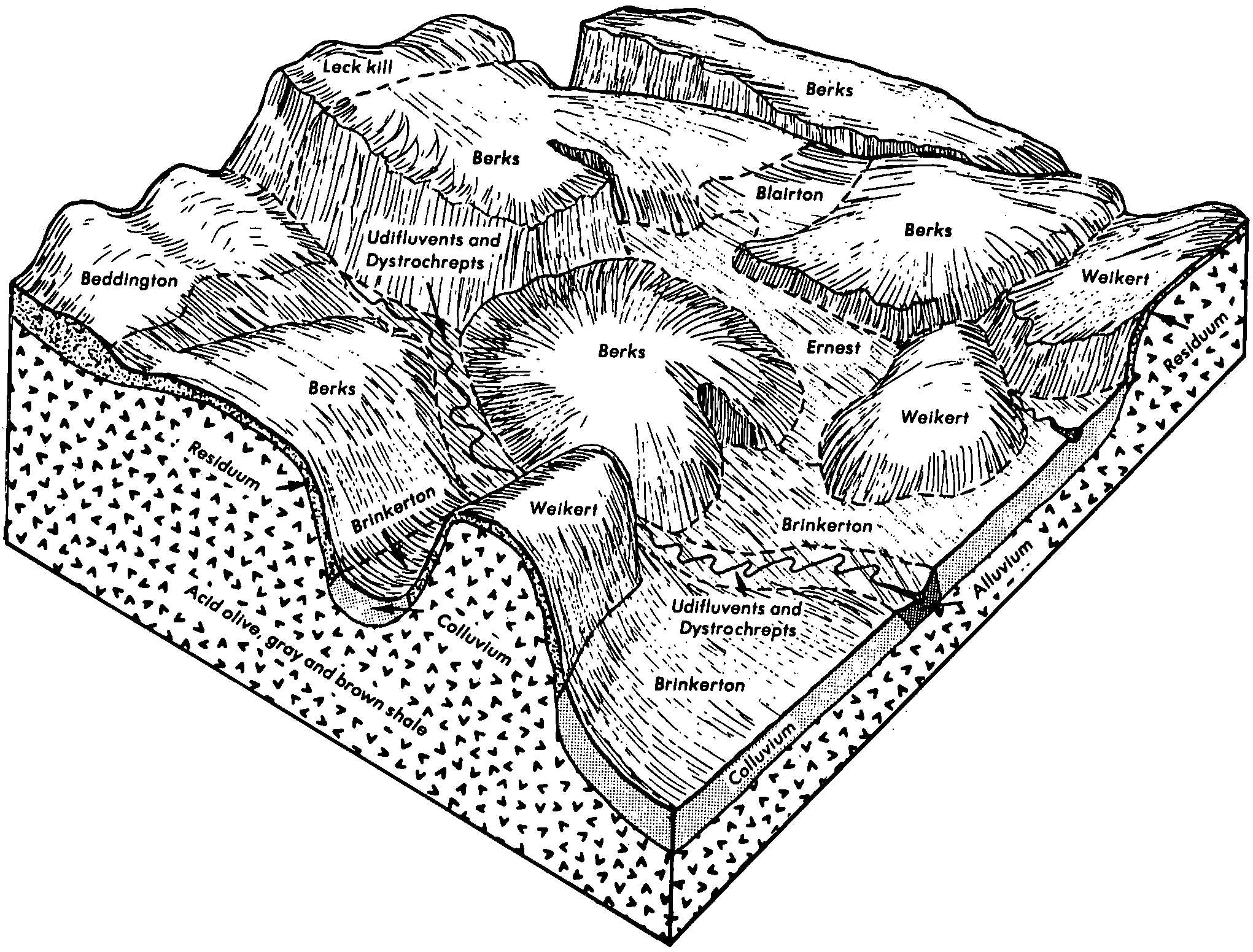
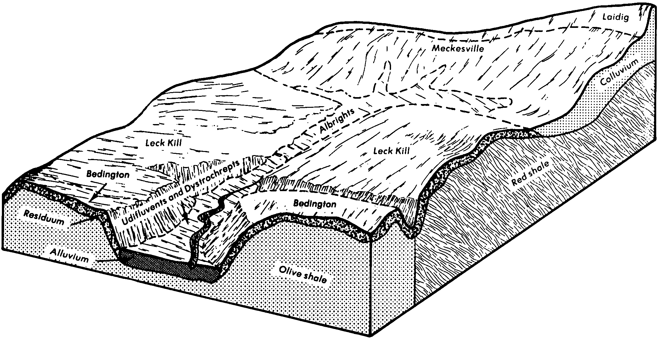
Udifluvents-Dystrochrepts complex | UD | 7750 | 542407 | l6f0 | pa013 | 1978 | 1:20000 |
Udifluvents, sandy | Ud | 1719 | 538555 | l2dr | pa033 | 1981 | 1:20000 |
Udifluvents, loamy | Ud | 7847 | 539123 | l302 | pa081 | 1981 | 1:20000 |
Udifluvents and Fluvaquents, gravelly | Ug | 402 | 539023 | l2wv | pa093 | 1980 | 1:20000 |
Udifluvents, coal overwash | Uf | 4272 | 539669 | l3kp | pa097 | 1980 | 1:20000 |
Udifluvents and Fluvaquents, gravelly | Ug | 704 | 539670 | l3kq | pa097 | 1980 | 1:20000 |
Udifluvents and Fluvaquents, 0 to 3 percent slopes, frequently flooded | UdA | 3886 | 2450611 | 2n81z | pa105 | 2007 | 1:24000 |
Udifluvents, coal overwash | UD | 2376 | 539755 | l3ng | pa107 | 1977 | 1:20000 |
Udifluvents, gravelly | UF | 1495 | 539756 | l3nh | pa107 | 1977 | 1:20000 |
Udifluvents and Fluvaquents, gravelly | Ug | 247 | 540847 | l4sp | pa109 | 1980 | 1:20000 |
Udifluvents and Fluvaquents, gravelly | Ug | 2523 | 540947 | l4wx | pa119 | 1980 | 1:20000 |
Udifluvents-Buchanan complex | Ub | 6377 | 539194 | l32c | pa607 | 1986 | 1:20000 |
Udifluvents, cobbly | Uc | 23293 | 296783 | 9ytn | pa610 | 1978 | 1:20000 |
Aquic Udifluvents | AU | 1600 | 131937 | 4f91 | sc015 | 1974 | 1:20000 |
Urban land-Udifluvents loamy complex, 0 to 6 percent slopes | G645B | 98 | 2797701 | 2q5vm | sd013 | 1987 | 1:20000 |
Udifluvents, loamy and sandy, frequently flooded | Ud | 1067 | 523784 | kl18 | tn139 | 1997 | 1:24000 |
Udifluvents, loamy | 82 | 2998 | 518072 | kd30 | va015 | 1978 | 1:15840 |
Udifluvents | 2 | 397 | 118858 | 3zp4 | va041 | 1974 | 1:15840 |
Udifluvents, nearly level | 67 | 480 | 119163 | 3zzz | va085 | 1976 | 1:15840 |
Fluvaquents-Udifluvents complex | 23 | 16627 | 120406 | 4192 | va177 | 1980 | 1:15840 |
Udorthents-Udifluvents complex, gently sloping | 45B | 4019 | 120447 | 41bd | va177 | 1980 | 1:15840 |
Fluvaquents-Udifluvents complex | 23 | 120 | 2376407 | 2krv9 | va630 | 2008 | 1:12000 |
Udorthents-Udifluvents complex, gently sloping | 45B | 43 | 2376415 | 2krvk | va630 | 2008 | 1:12000 |
Udifluvents-Urban land complex | 582 | 134 | 3098534 | 2y9rd | va790 | | 1:12000 |
Udifluvents, loamy | 82 | 12 | 3098516 | 2y9qw | va790 | | 1:12000 |
Udifluvents, loamy | 82 | 1 | 3025770 | 2xvcv | va820 | | 1:12000 |
Cobbly alluvial land | Co | 245 | 281242 | 9fnb | vt001 | 1967 | 1:15840 |
Udifluvents, loamy-skeletal | 28A | 1204 | 281434 | 9fvj | vt003 | 1992 | 1:20000 |
Alluvial land | An | 799 | 281663 | 9g2x | vt007 | 1969 | 1:15840 |
Udifluvents, frequently flooded | Ud | 1186 | 281953 | 9gd8 | vt015 | 1979 | 1:20000 |
Udifluvents and Fluvaquents, nearly level | 28 | 1734 | 282271 | 9gqj | vt021 | 1985 | 1:20000 |
Udifluvents, loamy | 64 | 630 | 282058 | 9ghn | vt025 | 1984 | 1:20000 |
Udifluvents, cobbly, frequently flooded | 82 | 430 | 283297 | 9hsm | vt027 | 2000 | 1:20000 |
Riverwash-Udifluvents complex, 1 to 5 percent slopes | 900AZ | 51 | 696131 | rccv | wa609 | 1979 | 1:24000 |
Udifluvents, 1 to 5 percent slopes | 901AZ | 3342 | 78188 | 2mc6 | wa632 | 2000 | 1:24000 |
Riverwash-Udifluvents complex, 1 to 5 percent slopes | 900AZ | 1920 | 78277 | 2mg2 | wa632 | 2000 | 1:24000 |
Udifluvents, moist, 0 to 8 percent slopes | 267 | 4625 | 74079 | 2h2n | wa634 | 1986 | 1:24000 |
Udifluvents, moist, 0 to 8 percent slopes | 267A | 1 | 1155399 | 17s8y | wa641 | 1980 | 1:24000 |
Udifluvents, loamy to clayey, 0 to 6 percent slopes, occasionally flooded | 2092B | 276 | 782464 | v86s | wi007 | 2005 | 1:12000 |
Udifluvents, loamy, nearly level | 2090A | 1191 | 421600 | g4q0 | wi017 | 1985 | 1:15840 |
Udifluvents | 2090A | 1551 | 423659 | g6vf | wi027 | 1976 | 1:15840 |
Udifluvents, loamy to clayey, 0 to 6 percent slopes, occasionally flooded | 2092B | 2073 | 1480641 | 1lpqm | wi031 | 2005 | 1:12000 |
Udifluvents | 2090A | 887 | 422356 | g5hd | wi061 | 1978 | 1:15840 |
Udifluvents | 2090A | 682 | 422603 | g5rc | wi087 | 1975 | 1:15840 |
Udifluvents | 2090A | 968 | 422204 | g5bh | wi109 | 1975 | 1:15840 |
Udifluvents-Fluvaquents complex | Uf | 1102 | 553081 | lkjb | wv025 | 2002 | 1:24000 |
Udifluvents, gravelly | UA | 8546 | 512863 | k6nz | wv039 | 1976 | 1:20000 |
Udifluvents, loamy | UB | 4169 | 512864 | k6p0 | wv039 | 1976 | 1:20000 |
Udifluvents-Fluvaquents complex | Uf | 3169 | 1605893 | 1qx20 | wv063 | 1962 | 1:24000 |
Udifluvents-Fluvaquents complex | Uf | 4848 | 515447 | k9cb | wv075 | 1992 | 1:24000 |
Fluvaquents and Udifluvents, frequently flooded | FU | 65 | 1600447 | 1qqdb | wv077 | 1955 | 1:20000 |
Udifluvents and Fluvaquents, frequently flooded | UA | 590 | 513188 | k70g | wv079 | 1981 | 1:20000 |
Fluvaquents and Udifluvents, frequently flooded | Fu | 824 | 515467 | k9cz | wv097 | 1981 | 1:20000 |
Fluvaquents-Udifluvents complex | Fu | 4079 | 513957 | k7t8 | wv602 | 1965 | 1:20000 |
Stony alluvial land (Udifluvents) | Sv | 155 | 514040 | k7wy | wv602 | 1965 | 1:20000 |
Udifluvents, cobbly | Ud | 5428 | 515613 | k9jp | wv603 | 1978 | 1:20000 |
Fluvaquents-Udifluvents complex | Fu | 1862 | 515574 | k9hf | wv603 | 1978 | 1:20000 |
Udifluvents and Fluvaquents, very gravelly | UF | 1536 | 555987 | lnk2 | wv608 | 1973 | 1:20000 |
Udifluvents and Fluvaquents | UF | 7418 | 515829 | k9rn | wv610 | 1973 | 1:20000 |
Udifluvents and Psamments, frequently flooded | Ud | 1323 | 2516605 | k9zq | wv713 | | 1:24000 |