Spearfish-Nevee-Gullied land complex, 6 to 30 percent slopes
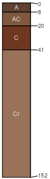
Spearfish
(45%)
Shallow Loamy-North (18-22 PZ)
Aridic Ustorthents
Well drained
Hydric: No
PAWS: 7 cm
hills / Summit
hills / Shoulder
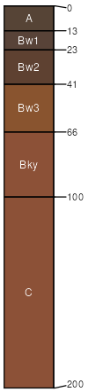
Nevee
(30%)
Thin Upland-North (18-22 PZ)
Typic Ustorthents
Well drained
Hydric: No
PAWS: 24 cm
hills / Backslope
hills / Footslope
Gullied land
(15%)
Non-site
Excessively drained
Hydric: No
PAWS: 4 cm
hills / Shoulder
hills / Backslope
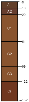
Tilford
(5%)
Loamy-North (18-22 PZ)
Typic Haplustolls
Well drained
Hydric: No
PAWS: 26 cm
terraces / Footslope
Nevee
(5%)
Thin Upland-North (18-22 PZ)
Typic Ustorthents
Well drained
Hydric: No
PAWS: 31 cm
hills / Backslope
hills / Footslope
SSA
Scale
Published
Export
sd081
1:24,000
2007
2025-09-10