Wateree-Rion-Rock outcrop complex, 2 to 15 percent slopes
Wateree
(60%)
Lower piedmont acidic upland woodland, depth restriction, dry
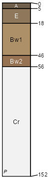
Typic Dystrudepts
Well drained
Hydric: No
PAWS: 5 cm
hills / Summit
hills / Shoulder
hills / Backslope
Rion
(25%)
Acidic upland forest, moist
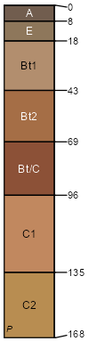
Typic Hapludults
Well drained
Hydric: No
PAWS: 19 cm
hills / Summit
hills / Shoulder
hills / Backslope
Rock outcrop
(15%)
Lower piedmont acidic upland woodland, depth restriction, dry
Hydric: Unranked
PAWS: 0 cm
hills / Summit
hills / Shoulder
hills / Backslope
SSA
Scale
Published
Export
ga639
1:24,000
2012
2025-08-29