Ratiopeak, bouldery-Poin complex, 15 to 45 percent slopes
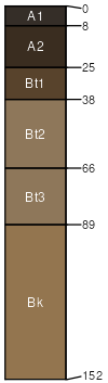
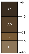
Ratiopeak
(50%)
Upland Sagebrush Shrubland Group
Ustic Argicryolls
Well drained
Hydric: No
PAWS: 13 cm
hills / Footslope
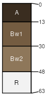
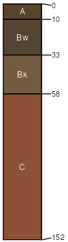
Poin
(20%)
Shallow Sagebrush Shrubland Group
Lithic Haplocryolls
Well drained
Hydric: No
PAWS: 4 cm
hillsides
Ratiopeak
(5%)
Upland Sagebrush Shrubland Group
Ustic Argicryolls
Well drained
Hydric: No
PAWS: 13 cm
hillsides
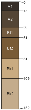
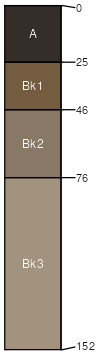
Philipsburg
(5%)
Upland Sagebrush Shrubland Group
Calcic Argicryolls
Well drained
Hydric: No
PAWS: 23 cm
hillslopes
Nathale
(5%)
Upland Sagebrush Shrubland Group
Ustic Argicryolls
Well drained
Hydric: No
PAWS: 9 cm
hillsides
Rock outcrop
(5%)
Hydric: Unranked
PAWS: NA
Cheadle
(4%)
Shallow Sagebrush Shrubland Group
Lithic Haplocryolls
Well drained
Hydric: No
PAWS: 4 cm
hillsides
Tiban
(3%)
Upland Sagebrush Shrubland Group
Ustic Haplocryolls
Well drained
Hydric: No
PAWS: 14 cm
hillsides
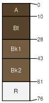
Farlin
(3%)
Upland Sagebrush Shrubland Group
Calcic Haplocryolls
Well drained
Hydric: No
PAWS: 13 cm
hillsides
SSA
Scale
Published
Export
mt612
1:24,000
2011
2025-08-30