| Philipsburg-Ratiopeak complex, 1 to 8 percent slopes | 6C | 88 | 2496296 | 2p9sl | id758 | 1998 | 1:24000 |
Wander-Woodhurst-Philipsburg families, complex, gentle mountain slopes | 527C | 71 | 2024050 | 25y5y | id758 | 1998 | 1:24000 |
Philipsburg-Ratiopeak complex, 1 to 8 percent slopes | 6C | 1634 | 2611470 | 2p9sl | id761 | 2018 | 1:24000 |
Blaine, very stony-Philipsburg-Cheadle, extremely stony complex, 15 to 35 percent slopes | 725E | 748 | 2611463 | 2pbbk | id761 | 2018 | 1:24000 |
Philipsburg-Blaine, very stony complex, 4 to 15 percent slopes | 725D | 584 | 2611462 | 2pbbj | id761 | 2018 | 1:24000 |
Ratiopeak, stony-Bullrey-Philipsburg complex, 15 to 35 percent slopes | 760E | 204 | 2611465 | 2pbbm | id761 | 2018 | 1:24000 |
Philipsburg-Tibson, stony complex, 4 to 15 percent slopes | 138D | 66 | 2611456 | vsc7 | id761 | 2018 | 1:24000 |
Philipsburg-Nieman-Woodhall complex, 4 to 15 percent slopes, very stony | 550D | 397 | 3039582 | wfwc | mt602 | 1963 | 1:20000 |
Philipsburg gravelly loam, 2 to 15 percent slopes | 38D | 7982 | 2597989 | vsgd | mt604 | 2001 | 1:24000 |
Tiban-Philipsburg-Shineberger complex, 15 to 45 percent slopes | 44E | 4405 | 609144 | nfvt | mt604 | 2001 | 1:24000 |
Philipsburg-Tiban-Houlihan complex, 15 to 45 percent slopes | 40E | 2956 | 609141 | nfvq | mt604 | 2001 | 1:24000 |
Philipsburg-Rockisland complex, 8 to 35 percent slopes | 138E | 330 | 2820840 | 2lwsk | mt604 | 2001 | 1:24000 |
Bridger-Benteen-Philipsburg families, complex, landslide deposits | 704E | 17333 | 148759 | 4zsp | mt605 | 2007 | 1:24000 |
Maciver-Philipsburg-Tiban families, complex, alluvial fans | 683P | 9947 | 628524 | p30z | mt605 | 2007 | 1:24000 |
Tiban-Philipsburg families, complex, moderately steep mountain slopes | 534P | 6444 | 148650 | 4zp5 | mt605 | 2007 | 1:24000 |
Philipsburg-Redchief-Sebud families, complex, ice-margin slopes | 467E | 4819 | 148594 | 4zmc | mt605 | 2007 | 1:24000 |
Maciver-Marcetta-Philipsburg families, complex, moderately steep mountain slopes | 533E | 4661 | 148818 | 4zvl | mt605 | 2007 | 1:24000 |
Philipsburg-Adel families, complex, cirque basins | 2510C | 3191 | 625761 | p04v | mt605 | 2007 | 1:24000 |
Philipsburg-Yellowmule-Midfork families, complex, cirque basins | 255C | 2382 | 148987 | 5011 | mt605 | 2007 | 1:24000 |
Philipsburg-Prudy-Maciver families, complex, alluvial fans | 683E | 1960 | 149306 | 50cb | mt605 | 2007 | 1:24000 |
Maciver, stony-Tiban, very stony-Philipsburg complex, 2 to 15 percent slopes | 108D | 1704 | 2403796 | 2lpbt | mt605 | 2007 | 1:24000 |
Philipsburg-Prudy-Tibson families, complex, ice-margin slopes | 463E | 1464 | 149325 | 50cy | mt605 | 2007 | 1:24000 |
Woodhurst-Philipsburg-Prudy families, complex, gentle mountain slopes | 523X | 1328 | 149297 | 50c1 | mt605 | 2007 | 1:24000 |
Maciver-Philipsburg-Wepota families, complex, moderately steep mountain slopes | 533X | 1293 | 148644 | 4znz | mt605 | 2007 | 1:24000 |
Prudy-Maciver-Philipsburg families, complex, gentle mountain slopes | 523P | 1160 | 149295 | 50bz | mt605 | 2007 | 1:24000 |
Wander-Woodhurst-Philipsburg families, complex, gentle mountain slopes | 527C | 1160 | 148621 | 4zn7 | mt605 | 2007 | 1:24000 |
Donald-Philipsburg complex, 2 to 15 percent slopes | 129D | 1142 | 2633447 | 2pgg3 | mt605 | 2007 | 1:24000 |
Philipsburg-Maciver-Prudy families, complex, alluvial fans | 683C | 944 | 148830 | 4zvz | mt605 | 2007 | 1:24000 |
Maciver, very bouldery-Philipsburg complex, 2 to 15 percent slopes | 90D | 882 | 2403791 | 2lpbn | mt605 | 2007 | 1:24000 |
Elkner-Philipsburg-Prudy families, complex, ice-margin slopes | 463P | 744 | 149225 | 508q | mt605 | 2007 | 1:24000 |
Philipsburg-Rockisland complex, 8 to 35 percent slopes | 138E | 583 | 2633433 | 2lwsk | mt605 | 2007 | 1:24000 |
Maciver-Philipsburg-Dunkleber, rarely flooded families, complex, alluvial-colluvial deposits | 613P | 529 | 149305 | 50c9 | mt605 | 2007 | 1:24000 |
Maciver, very stony-Philipsburg-Tibson, very stony complex, 8 to 35 percent slopes | 108E | 456 | 2403797 | 2lpbv | mt605 | 2007 | 1:24000 |
Philipsburg-Wander-Wetopa families, complex, alluvial-colluvial deposits | 6110C | 452 | 149315 | 50cm | mt605 | 2007 | 1:24000 |
Wetopa-Philipsburg-Prudy families, complex, gentle mountain slopes | 523C | 355 | 149229 | 508v | mt605 | 2007 | 1:24000 |
Philipsburg-Maciver complex, 2 to 8 percent slopes | 138C | 249 | 2450946 | 2n8ds | mt605 | 2007 | 1:24000 |
Philipsburg gravelly loam, 2 to 15 percent slopes | 38D | 197 | 2403820 | vsgd | mt605 | 2007 | 1:24000 |
Tibson, extremely stony-Philipsburg, very stony complex, 8 to 15 percent slopes | 94D | 141 | 2450921 | 2n8cz | mt605 | 2007 | 1:24000 |
Doolittle-Philipsburg-Hooligan complex, 2 to 15 percent slopes | 62D | 86 | 1859534 | 20dzz | mt605 | 2007 | 1:24000 |
Maciver, extremely stony-Philipsburg, very stony complex, 8 to 35 percent slopes | 8E | 75 | 2403777 | 2lpb6 | mt605 | 2007 | 1:24000 |
Philipsburg-Yacreek complex, 0 to 8 percent slopes | 781C | 74 | 2633451 | 2pphq | mt605 | 2007 | 1:24000 |
Philipsburg-Mussigbrod complex, 0 to 2 percent slopes | 35A | 51 | 1859523 | 20dzm | mt605 | 2007 | 1:24000 |
Philipsburg-Tibson, stony, complex, 4 to 15 percent slopes | 138D | 48 | 2450925 | 2n8d3 | mt605 | 2007 | 1:24000 |
Philipsburg, extremely stony-Levengood, extremely stony-Tropal, rubbly complex, 8 to 45 percent slopes, landslides | 128F | 43 | 2633434 | 2m78x | mt605 | 2007 | 1:24000 |
Philipsburg loam, 15 to 35 percent slopes | 38E | 43 | 2633437 | 2mfd3 | mt605 | 2007 | 1:24000 |
Ratiopeak-Philipsburg complex, 0 to 4 percent slopes | 48B | 40 | 2403823 | 2lpcp | mt605 | 2007 | 1:24000 |
Ratiopeak, very stony-Hooligan-Philipsburg complex, 8 to 35 percent slopes | 148E | 31 | 2403835 | 2lpd2 | mt605 | 2007 | 1:24000 |
Ratiopeak-Ratiopeak, very stony-Philipsburg complex, 4 to 15 percent slopes | 48D-H | 29 | 2403775 | 2lpb4 | mt605 | 2007 | 1:24000 |
Philipsburg-Mussigbrod complex, 4 to 15 percent slopes | 35D | 16 | 1859524 | 20dzn | mt605 | 2007 | 1:24000 |
Philipsburg, stony-Bridger complex, 4 to 15 percent slopes | 128D | 6 | 2496281 | 20qfr | mt605 | 2007 | 1:24000 |
Tibson-Rockisland-Philipsburg association, 15 to 50 percent slopes | 285F | 4 | 2496283 | 2lwsf | mt605 | 2007 | 1:24000 |
Philipsburg-Mussigbrod complex, 0 to 2 percent slopes | 35A | 9235 | 815466 | wckc | mt610 | 2005 | 1:24000 |
Philipsburg silt loam, 2 to 8 percent slopes | 32C | 6655 | 815859 | wcz1 | mt610 | 2005 | 1:24000 |
Doolittle-Philipsburg-Hooligan complex, 2 to 15 percent slopes | 62D | 2850 | 1400343 | 1j05c | mt610 | 2005 | 1:24000 |
Philipsburg-Mussigbrod complex, 4 to 15 percent slopes | 35D | 2465 | 1148716 | 17kbc | mt610 | 2005 | 1:24000 |
Danielvil-Englejard-Philipsburg complex, 0 to 4 percent slopes | 58B | 1406 | 1292477 | 1dcxt | mt610 | 2005 | 1:24000 |
Maciver-Philipsburg-Tiban families, complex, alluvial fans | 683P | 921 | 1531212 | 1ndby | mt610 | 2005 | 1:24000 |
Maciver-Philipsburg-Dunkleber families, complex, alluvial-colluvial deposits | 613P | 525 | 1531219 | 1ndc5 | mt610 | 2005 | 1:24000 |
Wander-Woodhurst-Philipsburg families, complex, gentle mountain slopes | 527C | 7 | 2911107 | 4zn7 | mt610 | 2005 | 1:24000 |
Maciver, very stony-Philipsburg-Tibson, very stony complex, 8 to 35 percent slopes | 108E | 16948 | 797888 | vs8b | mt612 | 2011 | 1:24000 |
Tibson-Rockisland-Philipsburg association, 15 to 50 percent slopes | 285F | 14128 | 2409984 | 2lwsf | mt612 | 2011 | 1:24000 |
Philipsburg gravelly loam, 2 to 15 percent slopes | 38D | 9932 | 798076 | vsgd | mt612 | 2011 | 1:24000 |
Philipsburg-Yacreek complex, 0 to 8 percent slopes | 781C | 8841 | 2493031 | 2pphq | mt612 | 2011 | 1:24000 |
Philipsburg-Tibson, stony complex, 4 to 15 percent slopes | 138D | 8616 | 797978 | vsc7 | mt612 | 2011 | 1:24000 |
Donald-Philipsburg complex, 2 to 15 percent slopes | 129D | 8359 | 2486544 | 2pgg3 | mt612 | 2011 | 1:24000 |
Philipsburg-Maciver complex, 2 to 8 percent slopes | 138C | 7493 | 1440454 | 1kbx8 | mt612 | 2011 | 1:24000 |
Philipsburg, stony-Bridger complex, 4 to 15 percent slopes | 128D | 7177 | 1868610 | 20qfr | mt612 | 2011 | 1:24000 |
Maciver, stony-Tibson, very stony-Philipsburg complex, 2 to 15 percent slopes | 108D | 6158 | 1906465 | 21ztw | mt612 | 2011 | 1:24000 |
Ratiopeak, very stony-Hooligan-Philipsburg complex, 8 to 35 percent slopes | 148E | 5314 | 1476715 | 1lkmz | mt612 | 2011 | 1:24000 |
Philipsburg-Rockisland complex, 8 to 35 percent slopes | 138E | 4848 | 2409988 | 2lwsk | mt612 | 2011 | 1:24000 |
Maciver, extremely stony-Philipsburg, very stony complex, 8 to 35 percent slopes | 8E | 4710 | 796613 | vqy6 | mt612 | 2011 | 1:24000 |
Ratiopeak-Ratiopeak, very stony-Philipsburg complex, 4 to 15 percent slopes | 48D | 3721 | 1407245 | 1j7c0 | mt612 | 2011 | 1:24000 |
Blaine, very stony-Philipsburg-Cheadle, extremely stony complex, 15 to 35 percent slopes | 725E | 3290 | 2482590 | 2pbbk | mt612 | 2011 | 1:24000 |
Philipsburg loam, 15 to 35 percent slopes | 38E | 3289 | 2425939 | 2mfd3 | mt612 | 2011 | 1:24000 |
Knep, stony-Philipsburg-Burnette complex, 8 to 35 percent slopes, landslides | 749E | 2647 | 2485014 | 2pdvr | mt612 | 2011 | 1:24000 |
Ratiopeak-Philipsburg complex, 0 to 4 percent slopes | 48B | 2043 | 1671913 | 1t3rp | mt612 | 2011 | 1:24000 |
Tibson, extremely stony-Philipsburg complex, 8 to 15 percent slopes | 94D | 2005 | 2379879 | 2kwg9 | mt612 | 2011 | 1:24000 |
Ratiopeak-Ratiopeak, very stony-Philipsburg complex, 15 to 35 percent slopes | 48E | 1622 | 1407247 | 1j7c2 | mt612 | 2011 | 1:24000 |
Philipsburg-Narrows complex, 2 to 8 percent slopes | 782C | 1587 | 2485017 | 2pdvv | mt612 | 2011 | 1:24000 |
Rooset, stony-Beechcreek, very stony-Philipsburg complex, 4 to 15 percent slopes | 580D | 1517 | 2424643 | 2md19 | mt612 | 2011 | 1:24000 |
Donald, stony-Doolittle, very stony-Philipsburg complex, 2 to 8 percent slopes | 68C | 1393 | 1907931 | 221c5 | mt612 | 2011 | 1:24000 |
Beancreek-Philipsburg complex, 0 to 4 percent slopes | 230B | 1369 | 2512865 | 2qbyq | mt612 | 2011 | 1:24000 |
Hysoop-Philipsburg association, 8 to 35 percent slopes, very stony | 226E | 996 | 1380072 | 1hb2g | mt612 | 2011 | 1:24000 |
Ratiopeak, stony-Bullrey-Philipsburg complex, 15 to 35 percent slopes | 760E | 835 | 2482592 | 2pbbm | mt612 | 2011 | 1:24000 |
Philipsburg-Maciver complex, 8 to 35 percent slopes, rubbly | 438E | 820 | 2482485 | 2pb75 | mt612 | 2011 | 1:24000 |
Philipsburg, extremely stony-Levengood, extremely stony-Tropal, rubbly complex, 8 to 45 percent slopes, landslides | 128F | 786 | 2420074 | 2m78x | mt612 | 2011 | 1:24000 |
Maciver, very bouldery-Philipsburg complex, 2 to 15 percent slopes | 90D | 762 | 1906388 | 21zrd | mt612 | 2011 | 1:24000 |
Maciver-Philipsburg complex, 4 to 15 percent slopes | 154D | 573 | 2482481 | 2pb71 | mt612 | 2011 | 1:24000 |
Philipsburg-Blaine, very stony complex, 4 to 15 percent slopes | 725D | 385 | 2482589 | 2pbbj | mt612 | 2011 | 1:24000 |
Tiban-Philipsburg families, complex, moderately steep mountain slopes | 534P | 155 | 2597709 | 4zp5 | mt612 | 2011 | 1:24000 |
Woodhurst-Philipsburg-Prudy families, complex, gentle mountain slopes | 523X | 117 | 2597768 | 50c1 | mt612 | 2011 | 1:24000 |
Maciver-Tibson-Phillipsburg complex, 2 to 8 percent slopes | 934C | 55 | 2597637 | 2pg9q | mt612 | 2011 | 1:24000 |
Maciver-Philipsburg-Dunkleber, rarely flooded families, complex, alluvial-colluvial deposits | 613P | 38 | 2597770 | 50c9 | mt612 | 2011 | 1:24000 |
Maciver-Philipsburg-Wepota families, complex, moderately steep mountain slopes | 533X | 13 | 2597708 | 4znz | mt612 | 2011 | 1:24000 |
Elkner-Philipsburg-Prudy families, complex, ice-margin slopes | 463P | 9 | 2597765 | 508q | mt612 | 2011 | 1:24000 |
Maciver-Philipsburg-Tiban families, complex, alluvial fans | 683P | 7 | 2511831 | p30z | mt612 | 2011 | 1:24000 |
Beancreek-Philipsburg complex, 0 to 4 percent slopes | 230B | 6324 | 2492962 | 2qbyq | mt614 | 2012 | 1:24000 |
Maciver, stony-Tibson, very stony-Philipsburg complex, 2 to 15 percent slopes | 108D | 5999 | 2517421 | 21ztw | mt614 | 2012 | 1:24000 |
Maciver, very stony-Philipsburg-Tibson, very stony complex, 8 to 35 percent slopes | 108E | 5515 | 2517422 | vs8b | mt614 | 2012 | 1:24000 |
Philipsburg-Yacreek complex, 0 to 8 percent slopes | 781C | 4820 | 2492961 | 2pphq | mt614 | 2012 | 1:24000 |
Maciver-Tibson-Phillipsburg complex, 2 to 8 percent slopes | 934C | 4464 | 2486408 | 2pg9q | mt614 | 2012 | 1:24000 |
Philipsburg-Maciver complex, 2 to 8 percent slopes | 138C | 3510 | 2492969 | 1kbx8 | mt614 | 2012 | 1:24000 |
Philipsburg gravelly loam, 2 to 15 percent slopes | 38D | 3293 | 2492958 | vsgd | mt614 | 2012 | 1:24000 |
Ratiopeak, very stony-Rooset, stony-Phillipsburg complex, 4 to 15 percent slopes | 945D | 3027 | 2486405 | 2pg9m | mt614 | 2012 | 1:24000 |
Maciver-Philipsburg complex, 4 to 15 percent slopes | 154D | 2289 | 2511836 | 2pb71 | mt614 | 2012 | 1:24000 |
Philipsburg-Tibson, stony complex, 4 to 15 percent slopes | 138D | 2125 | 2511837 | vsc7 | mt614 | 2012 | 1:24000 |
Philipsburg-Narrows complex, 2 to 8 percent slopes | 782C | 1589 | 2517450 | 2pdvv | mt614 | 2012 | 1:24000 |
Philipsburg-Tiban-Houlihan complex, 15 to 45 percent slopes | 40E | 1514 | 2520826 | nfvq | mt614 | 2012 | 1:24000 |
Ratiopeak-Ratiopeak, very stony-Philipsburg complex, 4 to 15 percent slopes | 48D | 1113 | 2517439 | 1j7c0 | mt614 | 2012 | 1:24000 |
Tiban-Philipsburg-Shineberger complex, 15 to 45 percent slopes | 44E | 1025 | 2520827 | nfvt | mt614 | 2012 | 1:24000 |
Tibson, extremely stony-Philipsburg complex, 8 to 15 percent slopes | 94D | 768 | 2520815 | 2kwg9 | mt614 | 2012 | 1:24000 |
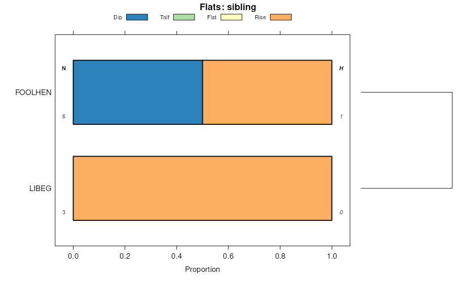
Truaxcreek-Foolhen complex, 0 to 4 percent slopes | 890B | 645 | 2520817 | 2ppbq | mt614 | 2012 | 1:24000 |
Ratiopeak, very stony-Hooligan-Philipsburg complex, 8 to 35 percent slopes | 148E | 91 | 2520726 | 1lkmz | mt614 | 2012 | 1:24000 |
Philipsburg, extremely stony-Levengood, extremely stony-Tropal, rubbly complex, 8 to 45 percent slopes, landslides | 128F | 84 | 3162832 | 2m78x | mt614 | 2012 | 1:24000 |
Blaine, very stony-Philipsburg-Cheadle, extremely stony complex, 15 to 35 percent slopes | 725E | 62 | 3162830 | 2pbbk | mt614 | 2012 | 1:24000 |
Tibson-Rockisland-Philipsburg association, 15 to 50 percent slopes | 285F | 34 | 2520728 | 2lwsf | mt614 | 2012 | 1:24000 |
Knep, stony-Philipsburg-Burnette complex, 8 to 35 percent slopes, landslides | 749E | 17 | 2541636 | 2pdvr | mt614 | 2012 | 1:24000 |
Philipsburg-Rockisland complex, 8 to 35 percent slopes | 138E | 12 | 2520725 | 2lwsk | mt614 | 2012 | 1:24000 |
Philipsburg loam, 8 to 25 percent slopes | 82E | 1123 | 155744 | 5720 | mt622 | 1997 | 1:24000 |
Philipsburg-Libeg complex, 4 to 8 percent slopes | 482C | 328 | 155524 | 56tx | mt622 | 1997 | 1:24000 |
Ratiopeak-Philipsburg complex, 2 to 4 percent slopes | 550B | 2310 | 2493432 | 2pqdj | mt624 | 2021 | 1:24000 |
Ratiopeak-Philipsburg complex, 4 to 8 percent slopes | 550C | 2242 | 2493433 | 2pqdk | mt624 | 2021 | 1:24000 |
Philipsburg-Poin, bouldery-Tuggle complex, 4 to 15 percent slopes | 522E | 1724 | 2486232 | 2pg41 | mt624 | 2021 | 1:24000 |
Cheadle-Blaine-Philipsburg complex, 8 to 25 percent slopes | 531E | 625 | 2487028 | 2pgyq | mt624 | 2021 | 1:24000 |
Philipsburg-Houlihan complex, 2 to 15 percent slopes | 501C | 420 | 1714519 | 1vk32 | mt624 | 2021 | 1:24000 |
Bridger-Philipsburg complex, 0 to 4 percent slopes | 500B | 186 | 1714518 | 1vk31 | mt624 | 2021 | 1:24000 |
Philipsburg, very bouldery-Nieman, very stony-Woodhall, very stony complex, 4 to 15 percent slopes | 550D | 25 | 2979644 | 2l9xv | mt624 | 2021 | 1:24000 |
Philipsburg, very bouldery-Nieman, very stony-Woodhall, very stony complex, 4 to 15 percent slopes | 550D | 1870 | 2392823 | 2l9xv | mt632 | | 1:24000 |
Philipsburg-Woodhall, stony-Bangtail complex, 15 to 35 percent slopes | 538E | 1060 | 2486264 | 2pg52 | mt632 | | 1:24000 |
Cheadle-Blaine-Philipsburg complex, 8 to 25 percent slopes | 531E | 204 | 2604457 | 2pgyq | mt632 | | 1:24000 |
Ratiopeak-Philipsburg complex, 15 to 35 percent slopes, very stony | 142E | 1071 | 1703127 | 1v57l | mt635 | 2006 | 1:24000 |
Kilgore-Foolhen-Philipsburg complex, 2 to 12 percent slopes | 597C | 25 | 1703196 | 1v59t | mt635 | 2006 | 1:24000 |
Philipsburg-Ratiopeak complex, 8 to 15 percent slopes | 115D | 19 | 1703125 | 1v57j | mt635 | 2006 | 1:24000 |
Tiban-Philipsburg-Roxal complex, 15 to 45 percent slopes | 246 | 1944 | 146608 | 4xk9 | mt636 | 1983 | 1:24000 |
Philipsburg gravelly loam, 2 to 15 percent slopes | 239 | 1064 | 146606 | vsgd | mt636 | 1983 | 1:24000 |
Philipsburg-Tiban-Adel complex, 15 to 45 percent slopes | 240 | 697 | 146607 | 4xk8 | mt636 | 1983 | 1:24000 |
Phillipsburg-Yellowmule-Midfork families, complex, cirque basins | 252 | 83 | 1710130 | 1vdjh | mt636 | 1983 | 1:24000 |
Maciver, very stony-Philipsburg-Tibson, very stony complex, 8 to 35 percent slopes | 108E | 7 | 2537034 | vs8b | mt636 | 1983 | 1:24000 |
Philipsburg-Woodhall, stony-Bangtail complex, 15 to 35 percent slopes | 538E | 2945 | 1389503 | 1hmwp | mt637 | 2014 | 1:24000 |
Philipsburg-Nieman-Woodhall complex, 4 to 15 percent slopes, very stony | 550D | 1743 | 817698 | wfwc | mt637 | 2014 | 1:24000 |
Owenspring-Hardhart-Philipsburg complex, 2 to 8 percent slopes | 358C | 854 | 780864 | v6k5 | mt637 | 2014 | 1:24000 |
Ratiopeak-Philipsburg complex, 4 to 8 percent slopes | 550C | 27 | 2517336 | 2pqdk | mt637 | 2014 | 1:24000 |
Philipsburg-Houlihan complex, 2 to 15 percent slopes | 501C | 226 | 2694638 | 1vk32 | mt639 | 2000 | 1:24000 |
Ratiopeak-Philipsburg complex, 4 to 8 percent slopes | 550C | 80 | 3312460 | 2pqdk | mt639 | 2000 | 1:24000 |
Maciver very bouldery - Philipsburg - Daileybasin complex, 4 to 35 percent slopes | 3517E | 3281 | 678688 | qs75 | mt669 | | 1:24000 |
Maciver very bouldery-Philipsburg-Marcel bouldery complex, 4 to 35 percent slopes | 3533E | 487 | 697301 | rdll | mt669 | | 1:24000 |
Philipsburg-Monaberg complex, 2 to 8 percent slopes | 148C | 3290 | 1424702 | 1jtj4 | mt670 | 2007 | 1:24000 |
Varney, noncalcic-Philipsburg-Varney complex, 2 to 15 percent slopes | 102D | 2151 | 1528060 | 1n928 | mt670 | 2007 | 1:24000 |
Philipsburg-Ratiopeak complex, 1 to 6 percent slopes | 147B | 1977 | 1424668 | 1jth1 | mt670 | 2007 | 1:24000 |
Ratiopeak-Philipsburg complex, 15 to 35 percent slopes, very stony | 142E | 1890 | 320488 | brhb | mt670 | 2007 | 1:24000 |
Philipsburg sandy loam, 1 to 4 percent slopes | 101B | 1734 | 151673 | 52tp | mt670 | 2007 | 1:24000 |
Philipsburg-Philipsburg, stony-Danielvil complex, 2 to 8 percent slopes | 161C | 1680 | 1424684 | 1jthk | mt670 | 2007 | 1:24000 |
Philipsburg-Ratiopeak complex, 8 to 15 percent slopes | 115D | 1468 | 1528061 | 1n929 | mt670 | 2007 | 1:24000 |
Sebud, stony-Danielvil-Monaberg, very stony complex, 8 to 30 percent slopes | 123E | 1431 | 320374 | brcn | mt670 | 2007 | 1:24000 |
Philipsburg loam, 2 to 8 percent slopes | 174C | 1355 | 1424671 | 1jth4 | mt670 | 2007 | 1:24000 |
Monaberg-Philipsburg complex, 2 to 12 percent slopes | 116C | 1295 | 320314 | br9q | mt670 | 2007 | 1:24000 |
Danielvil-Philipsburg complex, 4 to 12 percent slopes | 145D | 1080 | 1424658 | 1jtgq | mt670 | 2007 | 1:24000 |
Gnojek-Libeg-Philipsburg complex, 8 to 30 percent slopes, stony | 106E | 852 | 320375 | brcp | mt670 | 2007 | 1:24000 |
Philipsburg loam, 1 to 4 percent slopes, stony | 22B | 697 | 320251 | br7p | mt670 | 2007 | 1:24000 |
Monaberg-Varney-Philipsburg complex, 8 to 35 percent slopes | 159E | 656 | 1424686 | 1jthm | mt670 | 2007 | 1:24000 |
Kilgore, occasionally flooded-Foolhen, rarely flooded-Philipsburg complex, 2 to 12 percent slopes | 21C | 626 | 320247 | br7k | mt670 | 2007 | 1:24000 |
Kilgore-Foolhen-Philipsburg complex, 2 to 12 percent slopes | 597C | 594 | 1424756 | 1jtkw | mt670 | 2007 | 1:24000 |
Kilgore, rarely flooded-Mooseflat, occasionally flooded-Philipsburg complex, 0 to 6 percent slopes | 24B | 460 | 320241 | br7c | mt670 | 2007 | 1:24000 |
Philipsburg-Danielvil complex, 4 to 15 percent slopes | 129D | 427 | 320308 | br9j | mt670 | 2007 | 1:24000 |
Philipsburg cobbly loam, 0 to 4 percent slopes, very stony | 31A | 347 | 1424619 | 1jtfg | mt670 | 2007 | 1:24000 |
Sebud, very stony-Philipsburg-Ratiopeak, very stony complex, 4 to 15 percent slopes | 153D | 270 | 1424662 | 1jtgv | mt670 | 2007 | 1:24000 |
Philipsburg-Beeftrail, bouldery-Danielvil complex, 8 to 30 percent slopes | 301E | 266 | 362089 | d4s9 | mt670 | 2007 | 1:24000 |
Dumps, placer mining-Philipsburg, stony complex, 4 to 15 percent slopes | 131E | 265 | 320491 | brhf | mt670 | 2007 | 1:24000 |
Philipsburg-Monaberg-Kilgore, occasionally flooded complex, 0 to 15 percent slopes | 82D | 197 | 1424646 | 1jtgb | mt670 | 2007 | 1:24000 |
Sebud-Philipsburg complex, 8 to 25 percent slopes, bouldery | 111E | 173 | 320370 | brcj | mt670 | 2007 | 1:24000 |
Danielvil-Danielvil, cool-Philipsburg complex, 15 to 45 percent slopes | 141F | 106 | 320377 | brcr | mt670 | 2007 | 1:24000 |
Coldspring taxadjunct-Philipsburg complex, 10 to 50 percent slopes | 6703 | 1519 | 2487149 | 2ph2m | wy635 | | 1:24000 |
Moslander-Finn-Philipsburg complex, 0 to 4 percent slopes | 1208 | 971 | 1697518 | 1tzdn | wy635 | | 1:24000 |
Coldspring taxadjunct-Philipsburg complex, 10 to 50 percent slopes | 6703 | 6 | 2633699 | 2ph2m | wy663 | 2012 | 1:24000 |
Quakenasp-Philipsburg-Dranyon complex, 15 to 45 percent slopes | 8115 | 6681 | 3169689 | 2y0yg | wy723 | | 1:24000 |
Coldspring taxadjunct-Philipsburg complex, 10 to 50 percent slopes | 6703 | 2061 | 2554680 | 2ph2m | wy723 | | 1:24000 |
Quakenasp-Philipsburg-Dranyon complex, 4 to 15 percent slopes | 8112 | 1975 | 3169686 | 2y0yc | wy723 | | 1:24000 |
