Beavmid-like-Quander-Foolhen complex, 15 to 60 percent slopes -- Draft
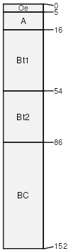
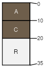
Beavmid-like
(35%)
Steep Loamy (SLy) Absaroka Upper Foothills
Ustic Argicryolls
Well drained
Hydric: No
PAWS: 26 cm
mountain slopes
landslides / Backslope
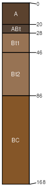
Quander
(30%)
Cobbly Upland (CoU) Absaroka Upper Foothills
Ustic Argicryolls
Well drained
Hydric: No
PAWS: 13 cm
mountain slopes
landslides / Shoulder
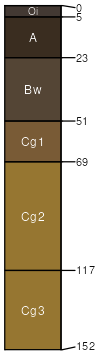
Foolhen
(10%)
Subirrigated High Mountains
Typic Cryaquolls
Very poorly drained
Hydric: Yes
PAWS: 21 cm
mountain slopes
flood plains
Rock outcrop
(10%)
Hydric: Unranked
PAWS: NA
Mawspring
(5%)
Coarse Upland (CU) 15-19 Foothills and Mountains East Precipitation Zone
Ustic Haplocryepts
Well drained
Hydric: No
PAWS: NA
Starman
(4%)
Coarse Upland (CU) 15-19 Foothills and Mountains East Precipitation Zone
Lithic Cryorthents
Well drained
Hydric: No
PAWS: 3 cm
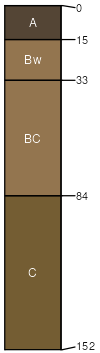
Tepete
(4%)
Wetland (WL) 15-19 Foothills and Mountains East Precipitation Zone
Terric Cryohemists
Poorly drained
Hydric: Yes
PAWS: 46 cm
mountain slopes
landslides / Toeslope
Water
(2%)
Hydric: Unranked
PAWS: NA
SSA
Scale
Published
Export
wy629
1:24,000
2025-09-04