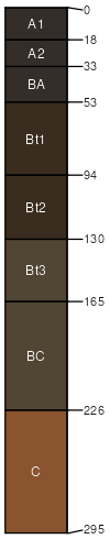
Summit silty clay loam, 2 to 5 percent slopes, eroded
Summit
(85%)
Loamy Upland
Oxyaquic Vertic Argiudolls
Moderately well drained
Hydric: No
PAWS: 30 cm
interfluves / Backslope
interfluves / Footslope
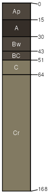
Snead
(8%)
Interbedded Sedimentary Upland Savanna
Aquic Hapludolls
Moderately well drained
Hydric: No
PAWS: 7 cm
interfluves / Backslope
Deepwater
(7%)
Loamy Upland
Typic Argiudolls
Moderately well drained
Hydric: No
PAWS: 36 cm
interfluves / Summit
SSA
Scale
Published
Export
mo101
1:24,000
1977
2025-09-02