Hayriver and Elevasil fine sandy loams, 12 to 20 percent slopes, moderately eroded
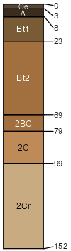
Hayriver
(45%)
Shallow Loamy-Silty Upland
Typic Hapludalfs
Well drained
Hydric: No
PAWS: 11 cm
hills / Shoulder
hills / Backslope
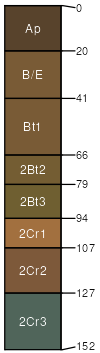
Elevasil
(44%)
Shallow Loamy-Silty Upland
Ultic Hapludalfs
Well drained
Hydric: No
PAWS: 13 cm
hills / Shoulder
hills / Backslope
Dobie
(6%)
Shallow Loamy-Silty Upland
Haplic Glossudalfs
Well drained
Hydric: No
PAWS: 18 cm
hills / Shoulder
hills / Backslope
Twinmound
(5%)
Shallow Dry Upland
Typic Quartzipsamments
Excessively drained
Hydric: No
PAWS: 4 cm
hills / Shoulder
hills / Backslope
SSA
Scale
Published
Export
wi033
1:12,000
2003
2025-09-10