| Elevasil sandy loam, 6 to 12 percent slopes, moderately eroded | 224C2 | 4266 | 2561753 | 2yt3c | wi011 | 1960 | 1:12000 |
Elevasil sandy loam, 20 to 30 percent slopes, moderately eroded | 224E2 | 3029 | 2561755 | 2yt3f | wi011 | 1960 | 1:12000 |
Elevasil sandy loam, 12 to 20 percent slopes, moderately eroded | 224D2 | 2983 | 2561754 | 2yt3d | wi011 | 1960 | 1:12000 |
Boone-Elevasil complex, 15 to 45 percent slopes, rocky | 1224F | 1991 | 2561756 | 2yt3h | wi011 | 1960 | 1:12000 |
Elevasil sandy loam, 2 to 6 percent slopes | 224B | 1580 | 2561752 | 2yt3b | wi011 | 1960 | 1:12000 |
Elevasil sandy loam, 6 to 12 percent slopes, moderately eroded | 224C2 | 5065 | 421515 | 2yt3c | wi017 | 1985 | 1:15840 |
Elevasil sandy loam, 2 to 6 percent slopes | 224B | 3759 | 421514 | 2yt3b | wi017 | 1985 | 1:15840 |
Elevasil sandy loam, 12 to 20 percent slopes, moderately eroded | 224D2 | 978 | 421516 | 2yt3d | wi017 | 1985 | 1:15840 |
Boone-Elevasil complex, 15 to 45 percent slopes, rocky | 1224F | 1179 | 431845 | 2yt3h | wi019 | 1994 | 1:20000 |
Elevasil sandy loam, 6 to 12 percent slopes, moderately eroded | 224C2 | 657 | 431857 | 2yt3c | wi019 | 1994 | 1:20000 |
Elevasil sandy loam, 2 to 6 percent slopes | 224B | 365 | 431856 | 2yt3b | wi019 | 1994 | 1:20000 |
Elevasil sandy loam, 12 to 20 percent slopes, moderately eroded | 224D2 | 248 | 431858 | 2yt3d | wi019 | 1994 | 1:20000 |
Elevasil sandy loam, 20 to 30 percent slopes, moderately eroded | 224E2 | 2176 | 2503942 | 2yt3f | wi023 | 1960 | 1:12000 |
Elevasil sandy loam, 12 to 20 percent slopes, moderately eroded | 224D2 | 1302 | 2498194 | 2yt3d | wi023 | 1960 | 1:12000 |
Boone-Elevasil complex, 15 to 45 percent slopes, rocky | 1224F | 470 | 2499167 | 2yt3h | wi023 | 1960 | 1:12000 |
Elevasil sandy loam, 20 to 30 percent slopes, very stony | 231E | 243 | 2503948 | 2lb3p | wi023 | 1960 | 1:12000 |
Elevasil sandy loam, 6 to 12 percent slopes, moderately eroded | 224C2 | 114 | 2498146 | 2yt3c | wi023 | 1960 | 1:12000 |
Elevasil sandy loam, 12 to 20 percent slopes, very stony | 231D | 72 | 2503945 | 2lb3n | wi023 | 1960 | 1:12000 |
Elevasil sandy loam, 2 to 6 percent slopes | 224B | 13 | 2498139 | 2yt3b | wi023 | 1960 | 1:12000 |
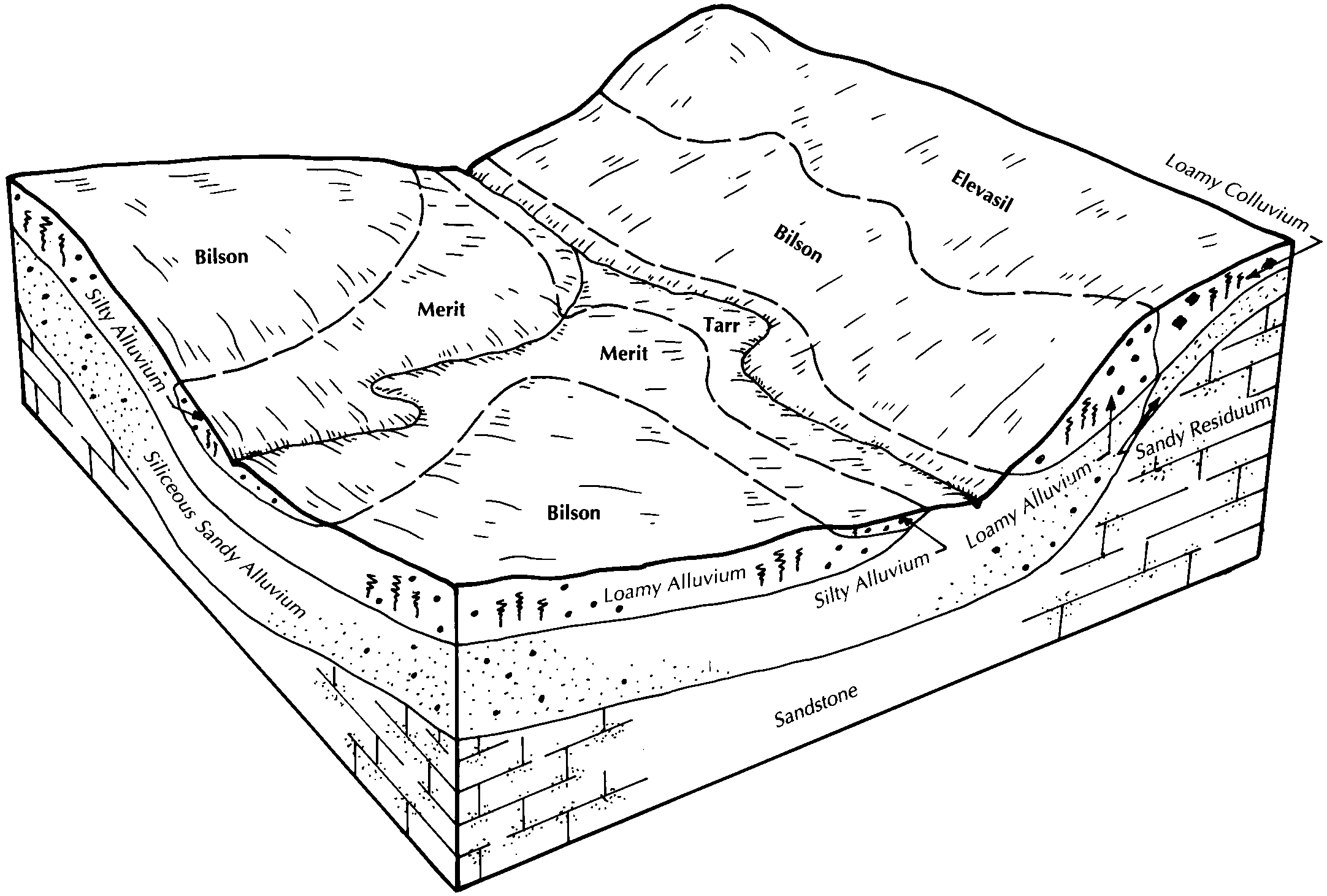
Hayriver and Elevasil fine sandy loams, 6 to 12 percent slopes, moderately eroded | 275C2 | 8901 | 2518509 | n56p | wi033 | 2003 | 1:12000 |
Hayriver and Elevasil fine sandy loams, 12 to 20 percent slopes, moderately eroded | 275D2 | 8896 | 2518510 | n56r | wi033 | 2003 | 1:12000 |
Elevasil sandy loam, 6 to 12 percent slopes, moderately eroded | 224C2 | 6245 | 2498147 | 2yt3c | wi033 | 2003 | 1:12000 |
Elevasil sandy loam, 2 to 6 percent slopes | 224B | 4911 | 2498140 | 2yt3b | wi033 | 2003 | 1:12000 |
Hayriver and Elevasil fine sandy loams, 2 to 6 percent slopes, moderately eroded | 275B2 | 3747 | 2518508 | n56m | wi033 | 2003 | 1:12000 |
Elevasil sandy loam, 12 to 20 percent slopes, moderately eroded | 224D2 | 1062 | 2498195 | 2yt3d | wi033 | 2003 | 1:12000 |
Boone-Elevasil complex, 15 to 45 percent slopes, rocky | 1224F | 608 | 2499168 | 2yt3h | wi033 | 2003 | 1:12000 |
Elevasil sandy loam, 20 to 30 percent slopes, moderately eroded | 224E2 | 221 | 2503943 | 2yt3f | wi033 | 2003 | 1:12000 |
Elevasil sandy loam, 6 to 12 percent slopes, moderately eroded | 224C2 | 6012 | 3099732 | 2yt3c | wi035 | 1974 | 1:12000 |
Elevasil sandy loam, 2 to 6 percent slopes | 224B | 4754 | 3099731 | 2yt3b | wi035 | 1974 | 1:12000 |
Elevasil sandy loam, 12 to 20 percent slopes, moderately eroded | 224D2 | 3206 | 3099733 | 2yt3d | wi035 | 1974 | 1:12000 |
Boone-Elevasil complex, 15 to 45 percent slopes, rocky | 1224F | 403 | 3099665 | 2yt3h | wi035 | 1974 | 1:12000 |
Elevasil sandy loam, 20 to 30 percent slopes, moderately eroded | 224E2 | 19 | 3099736 | 2yt3f | wi035 | 1974 | 1:12000 |
Elevasil sandy loam, 20 to 30 percent slopes, very stony | 231E | 433 | 2774807 | 2lb3p | wi049 | 1960 | 1:20000 |
Elevasil sandy loam, 12 to 20 percent slopes, very stony | 231D | 190 | 2774806 | 2lb3n | wi049 | 1960 | 1:20000 |
Boone-Elevasil complex, 15 to 45 percent slopes, rocky | 1224F | 30869 | 2499170 | 2yt3h | wi053 | 1994 | 1:12000 |
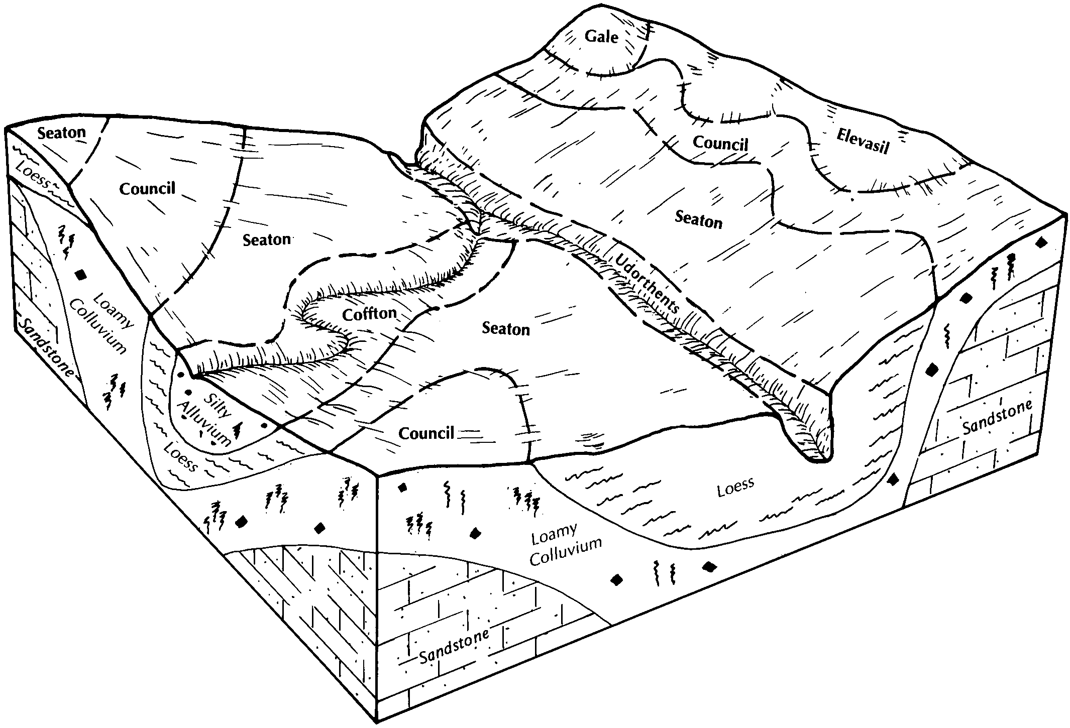
Council-Elevasil-Norden complex, 20 to 45 percent slopes, rocky | 1743F | 24283 | 2501375 | 2yt3g | wi053 | 1994 | 1:12000 |
Bilson-Elevasil sandy loams, 6 to 12 percent slopes, eroded | 1234C2 | 7743 | 2499176 | 2fj6n | wi053 | 1994 | 1:12000 |
Elevasil sandy loam, 6 to 12 percent slopes, moderately eroded | 224C2 | 4261 | 2498148 | 2yt3c | wi053 | 1994 | 1:12000 |
Elevasil sandy loam, 2 to 6 percent slopes | 224B | 4162 | 2498141 | 2yt3b | wi053 | 1994 | 1:12000 |
Elevasil sandy loam, 12 to 20 percent slopes, moderately eroded | 224D2 | 3445 | 2498196 | 2yt3d | wi053 | 1994 | 1:12000 |
Bilson-Elevasil sandy loams, 12 to 20 percent slopes, eroded | 1234D2 | 1310 | 2499177 | 2fj6p | wi053 | 1994 | 1:12000 |
Council-Elevasil-Norden complex, 20 to 45 percent slopes, rocky | 1743F | 21265 | 2561486 | 2yt3g | wi057 | 1987 | 1:12000 |
Elevasil sandy loam, 2 to 6 percent slopes | 224B | 1571 | 2561521 | 2yt3b | wi057 | 1987 | 1:12000 |
Elevasil sandy loam, 6 to 12 percent slopes, moderately eroded | 224C2 | 968 | 2561522 | 2yt3c | wi057 | 1987 | 1:12000 |
Elevasil sandy loam, 12 to 20 percent slopes, moderately eroded | 224D2 | 819 | 2561523 | 2yt3d | wi057 | 1987 | 1:12000 |
Boone-Elevasil complex, 15 to 45 percent slopes, rocky | 1224F | 701 | 2561455 | 2yt3h | wi057 | 1987 | 1:12000 |
Council-Elevasil-Norden complex, 20 to 45 percent slopes, rocky | 1743F | 19913 | 2501376 | 2yt3g | wi063 | 2001 | 1:12000 |
Elevasil sandy loam, 12 to 20 percent slopes, moderately eroded | 224D2 | 135 | 2498197 | 2yt3d | wi063 | 2001 | 1:12000 |
Elevasil sandy loam, 6 to 12 percent slopes, moderately eroded | 224C2 | 112 | 2498149 | 2yt3c | wi063 | 2001 | 1:12000 |
Elevasil sandy loam, 2 to 6 percent slopes | 224B | 89 | 2498142 | 2yt3b | wi063 | 2001 | 1:12000 |
Council-Elevasil-Norden complex, 20 to 45 percent slopes, rocky | 1743F | 29322 | 2685032 | 2yt3g | wi081 | 1981 | 1:12000 |
Boone-Elevasil complex, 15 to 45 percent slopes, rocky | 1224F | 11179 | 2685051 | 2yt3h | wi081 | 1981 | 1:12000 |
Elevasil sandy loam, 20 to 30 percent slopes, moderately eroded | 224E2 | 7772 | 2685077 | 2yt3f | wi081 | 1981 | 1:12000 |
Elevasil sandy loam, 12 to 20 percent slopes, moderately eroded | 224D2 | 2048 | 2685076 | 2yt3d | wi081 | 1981 | 1:12000 |
Elevasil sandy loam, 6 to 12 percent slopes, moderately eroded | 224C2 | 1346 | 2685075 | 2yt3c | wi081 | 1981 | 1:12000 |
Bilson-Elevasil sandy loams, 6 to 12 percent slopes, eroded | 1234C2 | 4 | 2685143 | 2fj6n | wi081 | 1981 | 1:12000 |
Boone-Elevasil complex, 15 to 45 percent slopes, rocky | 1224F | 351 | 2499169 | 2yt3h | wi091 | 1998 | 1:12000 |
Elevasil sandy loam, 6 to 12 percent slopes, moderately eroded | 224C2 | 68 | 2498151 | 2yt3c | wi091 | 1998 | 1:12000 |
Elevasil sandy loam, 2 to 6 percent slopes | 224B | 68 | 2498144 | 2yt3b | wi091 | 1998 | 1:12000 |
Elevasil sandy loam, 12 to 20 percent slopes, moderately eroded | 224D2 | 62 | 2498199 | 2yt3d | wi091 | 1998 | 1:12000 |
Elevasil fine sandy loam, till plain, 6 to 12 percent slopes, moderately eroded | 220C2 | 3302 | 1697404 | 1tz8z | wi093 | 2006 | 1:12000 |
Elevasil fine sandy loam, till plain, 12 to 20 percent slopes, moderately eroded | 220D2 | 1315 | 1697403 | 1tz8y | wi093 | 2006 | 1:12000 |
Council-Elevasil-Norden complex, 20 to 45 percent slopes, rocky | 1743F | 1866 | 2501377 | 2yt3g | wi103 | 2002 | 1:12000 |
Elevasil sandy loam, 12 to 20 percent slopes, very stony | 231D | 559 | 2503946 | 2lb3n | wi103 | 2002 | 1:12000 |
Council-Elevasil-Norden complex, 20 to 45 percent slopes, rocky | 1743F | 6979 | 3257825 | 2yt3g | wi111 | 1977 | 1:15840 |
Elevasil sandy loam, 20 to 30 percent slopes, moderately eroded | 224E2 | 4810 | 423145 | 2yt3f | wi111 | 1977 | 1:15840 |
Elevasil sandy loam, 2 to 6 percent slopes | 224B | 4319 | 423142 | 2yt3b | wi111 | 1977 | 1:15840 |
Elevasil sandy loam, 12 to 20 percent slopes, moderately eroded | 224D2 | 3633 | 423144 | 2yt3d | wi111 | 1977 | 1:15840 |
Elevasil sandy loam, 6 to 12 percent slopes, moderately eroded | 224C2 | 3301 | 423143 | 2yt3c | wi111 | 1977 | 1:15840 |
Boone-Elevasil complex, 15 to 45 percent slopes, rocky | 1224F | 1221 | 3257823 | 2yt3h | wi111 | 1977 | 1:15840 |
Boone-Elevasil complex, 15 to 45 percent slopes, rocky | 1224F | 61844 | 2639491 | 2yt3h | wi121 | 1969 | 1:12000 |
Elevasil sandy loam, 12 to 20 percent slopes, moderately eroded | 224D2 | 7889 | 2683464 | 2yt3d | wi121 | 1969 | 1:12000 |
Elevasil sandy loam, 6 to 12 percent slopes, moderately eroded | 224C2 | 5383 | 2683463 | 2yt3c | wi121 | 1969 | 1:12000 |
Elevasil sandy loam, 20 to 30 percent slopes, moderately eroded | 224E2 | 4322 | 2683465 | 2yt3f | wi121 | 1969 | 1:12000 |
Elevasil sandy loam, 2 to 6 percent slopes | 224B | 1610 | 2683462 | 2yt3b | wi121 | 1969 | 1:12000 |
Council-Elevasil-Norden complex, 20 to 45 percent slopes, rocky | 1743F | 641 | 2639495 | 2yt3g | wi121 | 1969 | 1:12000 |
Bilson-Elevasil sandy loams, 6 to 12 percent slopes, eroded | 1234C2 | 23 | 2683503 | 2fj6n | wi121 | 1969 | 1:12000 |
Council-Elevasil-Norden complex, 20 to 45 percent slopes, rocky | 1743F | 2999 | 2501378 | 2yt3g | wi123 | 1965 | 1:12000 |
Elevasil sandy loam, 12 to 20 percent slopes, very stony | 231D | 806 | 2503947 | 2lb3n | wi123 | 1965 | 1:12000 |
Elevasil sandy loam, 20 to 30 percent slopes, moderately eroded | 224E2 | 620 | 2503944 | 2yt3f | wi123 | 1965 | 1:12000 |
Elevasil sandy loam, 12 to 20 percent slopes, moderately eroded | 224D2 | 304 | 2498200 | 2yt3d | wi123 | 1965 | 1:12000 |
Elevasil sandy loam, 6 to 12 percent slopes, moderately eroded | 224C2 | 71 | 2498152 | 2yt3c | wi123 | 1965 | 1:12000 |
