Wateree-Rion complex, 10 to 15 percent slopes
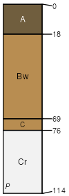
Wateree
(50%)
Acidic high hills and isolated ridges, depth restriction, dry
Typic Dystrudepts
Well drained
Hydric: No
PAWS: 9 cm
hills / Shoulder
hills / Backslope
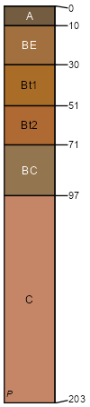
Rion
(45%)
Acidic upland forest, moist
Typic Hapludults
Well drained
Hydric: No
PAWS: 26 cm
hills / Shoulder
hills / Backslope
SSA
Scale
Published
Export
ga223
1:12,000
2010
2025-09-02