Rangecreek, very stony-Gompers-Sowers complex, 35 to 80 percent slopes
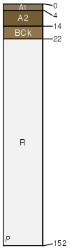
Rangecreek
(35%)
Upland Very Steep Shallow Loam (Pinyon-Utah Juniper)
Aridic Ustorthents
Well drained
Hydric: No
PAWS: 2 cm
mountain slopes
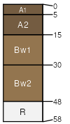
Gompers
(30%)
Upland Very Steep Shallow Loam (Pinyon-Utah Juniper)
Aridic Lithic Ustorthents
Well drained
Hydric: No
PAWS: 3 cm
mountain slopes
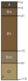
Sowers
(20%)
Upland Very Steep Loam (Salina Wildrye)
Aridic Calciustepts
Well drained
Hydric: No
PAWS: 12 cm
mountain slopes
Rock outcrop
(8%)
Hydric: No
PAWS: NA
cliffs
escarpments
ledges
Podo
(5%)
Upland Shallow Stony Loam (Two-Needle Pinyon /Douglas Fir)
Aridic Lithic Haplustepts
Well drained
Hydric: No
PAWS: NA
mountain slopes
Badland
(2%)
Hydric: No
PAWS: 0 cm
erosion remnants
hills / Backslope
ridges
SSA
Scale
Published
Export
ut013
1:24,000
2025-08-27