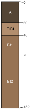
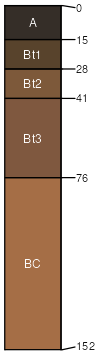
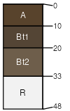
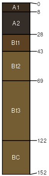
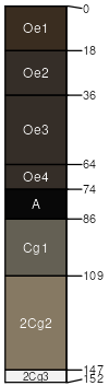
Butchhill, very stony-Hairpin, frequently ponded-Rooset, stony complex 2 to 35 percent slopes, landslides

Butchhill (25%)
Upland Sagebrush Shrubland Group
Alfic Argicryolls
Well drained
Hydric: No
PAWS: 16 cm
mountain slopes
Hairpin (20%)
Bottomland Group
Vertic Argicryolls
Well drained
Hydric: Yes
PAWS: 23 cm
landslides
Rooset (15%)
Upland Sagebrush Shrubland
Ustic Argicryolls
Well drained
Hydric: No
PAWS: 14 cm
mountain slopes
landslides
Mooseflat (10%)
Bottomland Group
Typic Cryaquolls
Very poorly drained
Hydric: Yes
PAWS: 19 cm
drainageways
flood plains
Libeg (10%)
Upland Shrubland Group
Ustic Argicryolls
Well drained
Hydric: No
PAWS: 14 cm
ridges
Nieman (8%)
Shallow Grassland Group
Lithic Argicryolls
Well drained
Hydric: No
PAWS: 5 cm
ridges
Rock outcrop (5%)


Hydric: Unranked
PAWS: NA
Monaberg (5%)
Upland Grassland Group
Ustic Argicryolls
Well drained
Hydric: No
PAWS: 24 cm
mountain slopes
Tepete (2%)
Subirrigated Grassland Group
Terric Cryohemists
Very poorly drained
Hydric: Yes
PAWS: 51 cm
landslides
SSAScalePublishedExport
mt6121:24,00020112023-08-24