Galestown-Urban land complex, 0 to 5 percent slopes
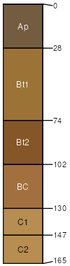
Galestown
(60%)
Sandy, Excessively Drained Upland
Psammentic Hapludults
Somewhat excessively drained
Hydric: No
PAWS: 18 cm
interfluves / Summit
Urban land
(30%)
Hydric: No
PAWS: NA
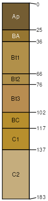
Swedesboro
(5%)
Well Drained Coarse-Loamy Upland
Typic Hapludults
Hydric: No
PAWS: NA
terraces
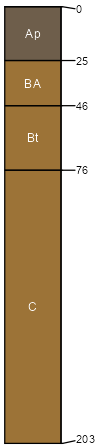
Downer
(5%)
Well Drained Coarse-Loamy Upland
Typic Hapludults
Well drained
Hydric: No
PAWS: NA
knolls / Summit
interfluves / Summit
SSA
Scale
Published
Export
md005
1:12,000
2010
2025-09-09