Official Series Description


Lab Data Summary

Aggregate lab data for the GALESTOWN soil series. This aggregation is based on all pedons with a current taxon name of GALESTOWN, and applied along 1-cm thick depth slices. Solid lines are the slice-wise median, bounded on either side by the interval defined by the slice-wise 5th and 95th percentiles. The median is the value that splits the data in half. Five percent of the data are less than the 5th percentile, and five percent of the data are greater than the 95th percentile. Values along the right hand side y-axis describe the proportion of pedon data that contribute to aggregate values at this depth. For example, a value of "90%" at 25cm means that 90% of the pedons correlated to GALESTOWN were used in the calculation. Source: KSSL snapshot . Methods used to assemble the KSSL snapshot used by SoilWeb / SDE

Click the image to view it full size.

Pedons used in the lab summary:

MLRALab IDPedon IDTaxonnameCINSSL / NASIS ReportsLink To SoilWeb GMap
149A89P036888MD033007Galestown6Primary | Supplementary | Taxonomy | Pedon | Water Retention | Correlation | Andic Soil Properties39.0275002,-76.8227768
149A40A0352S1958NJ005001Galestown4Primary | Supplementary | Taxonomy | Pedon | Water Retention | Correlation | Andic Soil Properties40.0131667,-74.9779472
149A40A0353S1958NJ005002Galestown5Primary | Supplementary | Taxonomy | Pedon | Water Retention | Correlation | Andic Soil Properties40.0488892,-74.9202805
153B40A5133S1958GA191001GALESTOWN6Primary | Supplementary | Taxonomy | Pedon | Water Retention | Correlation | Andic Soil Properties31.4590855,-81.4209442
153B40A5134S1958GA191002GALESTOWN6Primary | Supplementary | Taxonomy | Pedon | Water Retention | Correlation | Andic Soil Properties31.4576969,-81.3859406
153D84P000983MD019002Galestown7Primary | Supplementary | Taxonomy | Pedon | Water Retention | Correlation | Andic Soil Properties38.5705566,-75.8236084
153D84P001183MD019004Galestown5Primary | Supplementary | Taxonomy | Pedon | Water Retention | Correlation | Andic Soil Properties38.5463889,-75.7577778
153D86P011685MD019011Galestown7Primary | Supplementary | Taxonomy | Pedon | Water Retention | Correlation | Andic Soil Properties38.6661111,-75.8716667
153D87P011986MD019010Galestown5Primary | Supplementary | Taxonomy | Pedon | Water Retention | Correlation | Andic Soil Properties38.6494446,-75.7947235
153D87P012186MD019012Galestown5Primary | Supplementary | Taxonomy | Pedon | Water Retention | Correlation | Andic Soil Properties38.6733322,-75.753891
153D87P012286MD019013Galestown5Primary | Supplementary | Taxonomy | Pedon | Water Retention | Correlation | Andic Soil Properties38.5744438,-75.7983322
153D87P012386MD019014Galestown5Primary | Supplementary | Taxonomy | Pedon | Water Retention | Correlation | Andic Soil Properties38.5363889,-75.7722222
153D84P0013S1983MD019006Galestown7Primary | Supplementary | Taxonomy | Pedon | Water Retention | Correlation | Andic Soil Properties38.6175,-75.8277778
153D86P0115S1985MD019010Galestown7Primary | Supplementary | Taxonomy | Pedon | Water Retention | Correlation | Andic Soil Properties38.6388889,-75.8177778

Water Balance

Monthly water balance estimated using a leaky-bucket style model for the GALESTOWN soil series. Monthly precipitation (PPT) and potential evapotranspiration (PET) have been estimated from the 50th percentile of gridded values (PRISM 1981-2010) overlapping with the extent of SSURGO map units containing each series as a major component. Monthly PET values were estimated using the method of Thornthwaite (1948). These (and other) climatic parameters are calculated with each SSURGO refresh and provided by the fetchOSD function of the soilDB package. Representative water storage values (“AWC” in the figures) were derived from SSURGO by taking the 50th percentile of profile-total water storage (sum[awc_r * horizon thickness]) for each soil series. Note that this representation of “water storage” is based on the average ability of most plants to extract soil water between 15 bar (“permanent wilting point”) and 1/3 bar (“field capacity”) matric potential. Soil moisture state can be roughly interpreted as “dry” when storage is depleted, “moist” when storage is between 0mm and AWC, and “wet” when there is a surplus. Clearly there are a lot of assumptions baked into this kind of monthly water balance. This is still a work in progress.

Click the image to view it full size.


Click the image to view it full size.

Sibling Summary

Siblings are those soil series that occur together in map units, in this case with the GALESTOWN series. Sketches are arranged according to their subgroup-level taxonomic structure. Source: SSURGO snapshot , parsed OSD records and snapshot of SC database .

Click the image to view it full size.

Select annual climate data summaries for the GALESTOWN series and siblings. Series are sorted according to hierarchical clustering of median values. Source: SSURGO map unit geometry and 1981-2010, 800m PRISM data .

Click the image to view it full size.

Geomorphic description summaries for the GALESTOWN series and siblings. Series are sorted according to hierarchical clustering of proportions and relative hydrologic position within an idealized landform (e.g. top to bottom). Most soil series (SSURGO components) are associated with a hillslope position and one or more landform-specific positions: hills, mountain slopes, terraces, and/or flats. Proportions can be interpreted as an aggregate representation of geomorphic membership. The values printed to the left (number of component records) and right (Shannon entropy) of stacked bars can be used to judge the reliability of trends. Small Shannon entropy values suggest relatively consistent geomorphic association, while larger values suggest lack thereof. Source: SSURGO component records .

Click the image to view it full size.

Click the image to view it full size.

There are insufficient data to create the 3D mountains figure.

Click the image to view it full size.

Click the image to view it full size.

Competing Series

Soil series competing with GALESTOWN share the same family level classification in Soil Taxonomy. Source: parsed OSD records and snapshot of the SC database .

Click the image to view it full size.

Select annual climate data summaries for the GALESTOWN series and competing. Series are sorted according to hierarchical clustering of median values. Source: SSURGO map unit geometry and 1981-2010, 800m PRISM data .

Click the image to view it full size.

Geomorphic description summaries for the GALESTOWN series and competing. Series are sorted according to hierarchical clustering of proportions and relative hydrologic position within an idealized landform (e.g. top to bottom). Proportions can be interpreted as an aggregate representation of geomorphic membership. Most soil series (SSURGO components) are associated with a hillslope position and one or more landform-specific positions: hills, mountain slopes, terraces, and/or flats. The values printed to the left (number of component records) and right (Shannon entropy) of stacked bars can be used to judge the reliability of trends. Shannon entropy values close to 0 represent soil series with relatively consistent geomorphic association, while values close to 1 suggest lack thereof. Source: SSURGO component records .

Click the image to view it full size.

Click the image to view it full size.

There are insufficient data to create the 3D mountains figure.

Click the image to view it full size.

Click the image to view it full size.

Soil series sharing subgroup-level classification with GALESTOWN, arranged according to family differentiae. Hovering over a series name will print full classification and a small sketch from the OSD. Source: snapshot of SC database .

Block Diagrams

Click a link below to display the diagram. Note that these diagrams may be from multiple survey areas.

  1. DC-2011-05-31-05 | District of Columbia - 1976

    Diagram of Coastal Plain showing the pattern of soils and parent material (Soil Survey of District of Columbia; 1976).

  2. MD-2010-09-03-03 | City of Baltimore - 1998

    Pattern of soils in the Urban land-Joppa-Sassafras association (Soil Survey of City of Baltimore, Maryland; 1998).

  3. MD-2010-09-10-09 | Somerset County -

    Typical pattern of soils and underlying material in the Parsonsburg Sand Formation (Soil Survey of Somerset County, Maryland).

  4. MD-2012-02-03-04 | City of Baltimore - 1998

    Pattern of soils in the Urban land-Joppa-Sassafras association (Soil Survey of City of Baltimore, Maryland; 1998).

  5. MD-2012-02-03-07 | Baltimore County - March 1977

    Cross section showing typical pattern in the Sassafras-Woodstown-Fallsington association (Soil Survey of Baltimore County, Maryland; March 1976).

  6. MD-2012-02-03-12 | Dorchester County - 1998

    Typical profiles and landscape pattern of soils on flood plains adjacent to upland soils (Soil Survey of Dorchester County, Maryland; 1998).

Map Units

Map units containing GALESTOWN as a major component. Limited to 250 records.

Map Unit Name Symbol Map Unit Area (ac) Map Unit Key National Map Unit Symbol Soil Survey Area Publication Date Map Scale
Galestown-Urban land complex, 0 to 8 percent slopesGeB61412860249tgdc00119751:12000
Urban land-Galestown complex, 0 to 8 percent slopesUmB15312868049wzdc00119751:12000
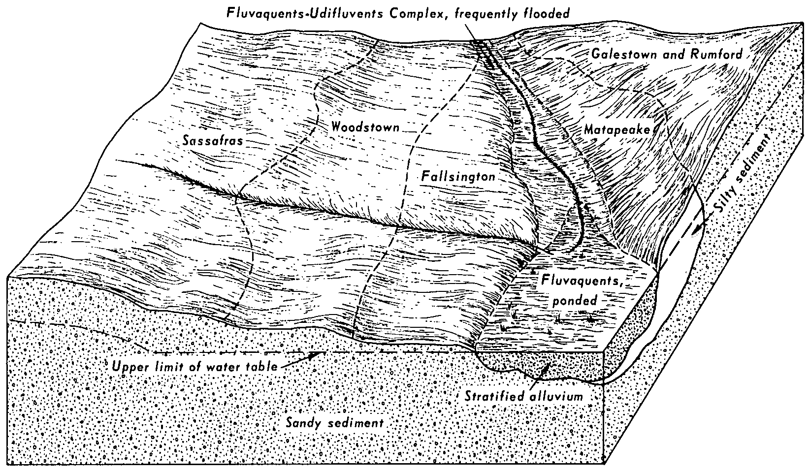
Galestown and Rumford soils, 0 to 8 percent slopesGfB9512860349thdc00119751:12000
Galestown and Rumford soils, 8 to 15 percent slopesGfC2112860449tjdc00119751:12000
Galestown loamy sand, 0 to 5 percent slopesGaB148616060401qx6rde00120061:24000
Galestown loamy sand, 5 to 15 percent slopesGaD8216060411qx6sde00120061:24000
Galestown loamy sand, 0 to 5 percent slopesGaB140716034041qtgqde00520061:24000
Galestown fine sand, 0 to 2 percent slopesGrA810012463245pdga19119601:20000
Galestown loamy sand, 0 to 5 percent slopesGaB42671375734m4vmd00320031:12000
Evesboro and Galestown soils, 5 to 10 percent slopesEVC39511377664mc2md00320031:12000
Evesboro-Galestown-Urban land complex, 5 to 15 percent slopesEuD1632609576ng9rmd00320031:12000
Evesboro-Galestown-Urban land complex, 15 to 25 percent slopesEuE956609578ng9tmd00320031:12000
Evesboro-Galestown-Urban land complex, 0 to 5 percent slopesEuB228609575ng9qmd00320031:12000
Galestown loamy sand, 5 to 10 percent slopesGbC11524042722lpv5md00520101:12000
Galestown loamy sand, 0 to 5 percent slopesGbB7724042712lpv4md00520101:12000
Galestown-Urban land complex, 0 to 5 percent slopesGcB4624042732lpv6md00520101:12000
Galestown-Woodstown complex, 5 to 10 percent slopesGwC348525168662pz81md00919671:20000
Galestown-Woodstown complex, 10 to 15 percent slopesGwD289825168672pz82md00919671:20000
Ingleside-Galestown complex, 0 to 5 percent slopesIgB48825168772pz8gmd00919671:20000
Ingleside loamy sand, 5 to 10 percent slopesIbC11325168732pz8bmd00919671:20000
Galestown and Rosedale soils, 15 to 30 percent slopesGAE308424800252p7ntmd01120091:12000
Galestown loamy sand, 2 to 5 percent slopesGaB176824526492nb5qmd01120091:12000
Galestown loamy sand, 0 to 2 percent slopesGaA130724526472nb5nmd01120091:12000
Galestown-Hammonton complex, 0 to 5 percent slopesGcB278916086221qzx1md01720071:12000
Galestown loamy sand, 2 to 5 percent slopesGaB47191289404b5cmd01919921:15840
Galestown loamy sand, 0 to 2 percent slopesGaA29501289394b5bmd01919921:15840
Galestown loamy sand, 0 to 5 percent slopesGaB1098127979495cmd02919781:15840
Galestown loamy sand, 5 to 15 percent slopesGaD321127980495dmd02919781:15840
Galestown loamy sand, 15 to 40 percent slopesGaE221127981495fmd02919781:15840
Swedesboro-Galestown complex, 0 to 5 percent slopesSwB82924552292ndvymd03320091:12000
Galestown-Urban land complex, 0 to 5 percent slopesGbB58624552302ndvzmd03320091:12000
Galestown-Urban land complex, 5 to 15 percent slopesGbD34724552312ndw0md03320091:12000
Galestown-Fort Mott loamy sands, 0 to 5 percent slopesGfB27131396954pc9md03519951:12000
Galestown-Fort Mott loamy sands, 5 to 10 percent slopesGfC3131396964pcbmd03519951:12000
Evesboro-Galestown complex, 2 to 5 percent slopesEzB7815990101qnwzmd03920061:12000
Galestown loamy sand, 2 to 5 percent slopesGaB114079521j82tmd03920061:12000
Galestown loamy sand, 2 to 5 percent slopesGaB50117125091vh07md04120091:12000
Galestown loamy sand, 2 to 5 percent slopesGaB40497556011r4pmd04520051:12000
Galestown loamy sand, 0 to 2 percent slopesGaA29097555911r4nmd04520051:12000
Galestown loamy sand, 2 to 5 percent slopesGaB18831293084bk7md04719951:12000
Galestown loamy sand, 5 to 10 percent slopesGaC10601293094bk8md04719951:12000
Galestown loamy sand, 0 to 2 percent slopesGaA8891293074bk6md04719951:12000
Galestown loamy sand, 0 to 8 percent slopes11B216533887kxk5md51019931:12000
Galestown-Urban land complex, 0 to 8 percent slopes11UB89533888kxk6md51019931:12000
Galestown sand, 0 to 5 percent slopesGabB12465697740rf1rnj00519671:24000
Galestown sand, clayey substratum, 0 to 5 percent slopesGabkB1660697741rf1snj00519671:24000
Galestown loamy sand, 0 to 5 percent slopesGadB17101351524jmrnj02119691:24000
Galestown sandy loam, 0 to 5 percent slopesGafB4631351534jmsnj02119691:24000
Downer-Galestown complex, 0 to 5 percent slopesDopB93591355964k32nj03320041:24000
Galestown sand, 0 to 5 percent slopesGabB34501356014k37nj03320041:24000
Aura-Galestown-Sassafras complex, 15 to 30 percent slopesAwE104824535612nc44va15319851:15840
Aura-Galestown-Sassafras complex, 6 to 15 percent slopesAwD37824535602nc43va15319851:15840
Galestown-Sassafras complex, 15 to 30 percent slopesGsE1449412052641dyva17919701:15840
Galestown-Sassafras complex, 6 to 15 percent slopesGsD770212052541dxva17919701:15840
Aura-Galestown-Sassafras complex, 15 to 30 percent slopesAwE520612048241cjva17919701:15840
Aura-Galestown-Sassafras complex, 6 to 15 percent slopesAwD275412048141chva17919701:15840
Galestown-Sassafras complex, 30 to 45 percent slopesGsF194612052741dzva17919701:15840

Map of Series Extent

Approximate geographic distribution of the GALESTOWN soil series. To learn more about how this distribution was mapped, or to compare this soil series extent to others, use the Series Extent Explorer (SEE) application. Source: generalization of SSURGO geometry .